
 Evaluation of public exposure to gamma radiation in Cotonou, southern Benin
Abstract
The objective of this study is to assess public exposure to natural background gamma radiation in Cotonou, southern Benin, in West Africa. This is a cross-sectional study with both descriptive and analytical aims, conducted from July to December 2024. The methodology involved continuous, georeferenced measurement of the ambient gamma dose rate at a height of one meter (1 m) above ground level using a spectrometer. The study sites included city streets and selected markets, including Dantokpa, an open-air market, and eight indoor markets. A total of 341,991 data points were recorded along the streets and 16,202 were recorded within the markets. The ambient gamma dose equivalent rate along the streets ranged from 4.67 to 136.84 nSv·h-1, with an average of 25.11 ± 12.72 nSv·h-1. The highest average rate was observed in District 5, which hosts a cement manufacturing plant. The average dose rates were 23.71 ± 12.90 nSv·h-1 at the Dantokpa market and 69.72 ± 21.96 nSv·h-1 in the indoor markets. In the latter, the dose rates were higher than those recorded in their respective districts. The estimated external annual effective doses were 0.04 ± 0.02 mSv for streets, 0.10 ± 0.06 mSv for Dantokpa, and 0.30 ± 0.09 mSv for indoor markets. These values remain below the worldwide average of 0.87 mSv, as recognized by the United Nations Scientific Committee on the Effects of Atomic Radiation for public exposure to natural radiation of terrestrial and cosmic origin. Overall, ambient gamma radiation exposure in Cotonou is low, though higher in enclosed market environments. These values may serve as baseline references for future studies in Cotonou and other African cities.
Ambient dose equivalent rate; Gamma radiation; Georeferenced measurement; Public radiation protection
Abstract
L’objectif de cette étude est d’évaluer l’exposition du public au rayonnement gamma de fond naturel à Cotonou, au sud du Bénin, en Afrique de l’Ouest. Il s’agit d’une étude transversale à visée descriptive et analytique, conduite de juillet à décembre 2024. La méthodologie a consisté en une mesure continue et géoréférencée du débit de dose gamma ambiant à un mètre (1 m) du sol à l’aide d’un spectromètre. Les sites d’étude comprenaient les rues de la ville et des marchés sélectionnés, notamment Dantokpa, un marché à ciel ouvert, et huit marchés couverts. Au total, 341 991 points ont été enregistrés le long des rues et 16 202 dans les marchés. Sur les rues, le débit d’équivalent de dose ambiant gamma variait entre 4,67 et 136,84 nSv·h-1, avec une moyenne de 25,11 ± 12,72 nSv·h-1. La moyenne la plus élevée a été observée dans le 5e arrondissement, qui abrite une cimenterie. Les moyennes étaient de 23,71 ± 12,90 nSv·h-1 au marché Dantokpa et de 69,72 ± 21,96 nSv·h-1 dans les marchés couverts. Dans ces derniers, les débits d’équivalent de dose étaient supérieurs à ceux mesurés dans les arrondissements d’implantation. Les doses efficaces annuelles externes estimées étaient de 0,04 ± 0,02 mSv pour les rues, 0,10 ± 0,06 mSv pour Dantokpa et 0,30 ± 0,09 mSv pour les marchés couverts. Ces valeurs restent inférieures à la moyenne mondiale de 0,87 mSv, reconnue par le Comité scientifique des Nations Unies pour l’étude des effets des rayonnements ionisants pour l’exposition du public aux rayonnements naturels d’origine terrestre et cosmique. De manière générale, l’exposition du public au rayonnement gamma ambiant à Cotonou est faible, bien qu’elle soit plus élevée dans les environnements clos des marchés. Ces valeurs pourraient servir de références de base pour de futures études à Cotonou et dans d’autres villes africaines.
Débit d’équivalent de dose ambiant; Rayonnement gamma; Mesure géoréférencée; Radioprotection du public
1. INTRODUCTION
Environmental radioactivity is the primary source of natural exposure to ionizing radiation for the general population. This exposure arises mainly from terrestrial gamma radiation emitted by naturally occurring radionuclides in the Earth’s crust, cosmic radiation from outer space, and radon gas, a radioactive decay product of uranium found in soil and rocks [1]. These sources are ubiquitous and contribute continuously to background radiation, although levels vary with geological and atmospheric conditions. According to Aswal, accurately assessing background radiation is essential not only for understanding long-term population exposure but also for informing environmental health policies and enhancing emergency preparedness [2]. Establishing baseline measurements of ambient dose rates is a prerequisite for detecting abnormal radiological events and safeguarding public health.
Although ambient radiation monitoring networks are well established and frequently updated in most developed countries, many regions of sub-Saharan Africa remain poorly monitored, and publicly available environmental radiological data are limited [3]. In Benin, this lack of data can be attributed in part to the delayed development of radiation protection infrastructure, which remained minimal until the adoption of national nuclear safety and radiological protection laws [4].
In addition to natural exposure, artificial sources from human activities, especially in healthcare, industry, and research, also contribute to population exposure. Ionizing radiation from these sources can interact with living tissues and cause biological damage. Such damage may result in deterministic effects at high doses and stochastic effects, such as radiation-induced cancers, at even low doses [5, 6]. According to the United Nations Scientific Committee on the Effects of Atomic Radiation, stochastic effects have no threshold, justifying the application of the precautionary principle in chronic exposure scenarios [7, 8].
The World Health Organization recommends the implementation of ambient radioactivity monitoring systems, particularly in densely populated urban areas [9]. The natural background radiation level varies greatly depending on the regional geology and the concentration of naturally occurring radioactive materials [10]. Mapping ambient radioactivity not only supports public health protection but also serves as a critical reference in the event of accidental or intentional radiological incidents. However, such mapping remains largely absent in Benin, with existing measurements limited to selected sites in the Collines Department in the central part of the country [11].
In this context, the present study was conducted in Cotonou, southern Benin, to assess public exposure to ionizing radiation by measuring ambient gamma dose equivalent rates.
2. STUDY AREA, MATERIALS, AND METHODS
2.1 Study Area
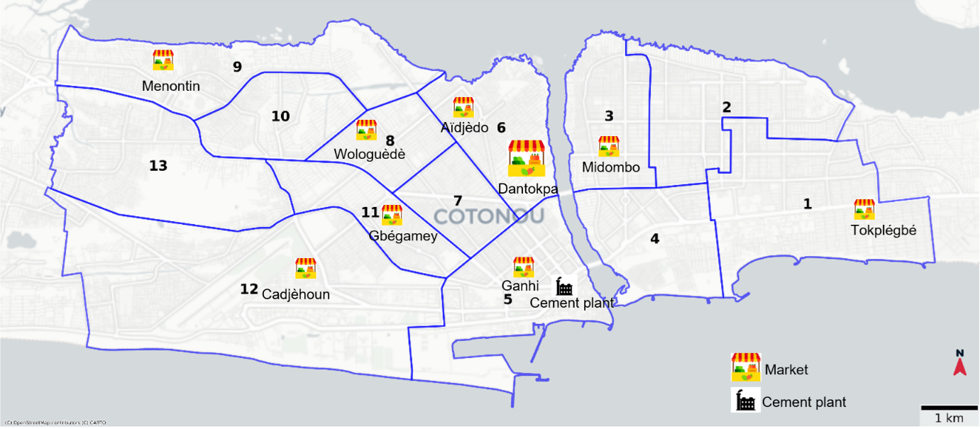
The study was conducted between July and December 2024 in the city of Cotonou, which is located in southern Benin, West Africa, between 6°22′ N latitude and 2°26′ E longitude. Cotonou is the only municipality in the Littoral Department, one of Benin’s twelve administrative divisions. It is the economic capital of the country and the most urbanized city, and is subdivided into 13 districts. The city covers an area of 79 km2 and had an estimated population of 738,400 in 2024, resulting in a population density of 9,347 inhabitants per square kilometer [12]. Cotonou lies on a coastal strip between Lake Nokoué to the north and the Atlantic Ocean to the south. A lagoon crosses the city, dividing it into two zones connected by three bridges. The western part of the city accounts for approximately 70% of the total area and hosts key infrastructures, including the Autonomous Port of Cotonou, the international airport, and a cement manufacturing plant located in District 5. The eastern zone comprises a major industrial area with several manufacturing and logistics companies. A comprehensive street network survey was conducted in the western part of the city (districts 5 to 13). The eastern part (Districts 1 to 4) was also surveyed, although less extensively, with selected routes explored between districts but without full street coverage.
The study also included several markets in Cotonou, which are areas of high human concentration. These markets included the open-air Dantokpa market, located in District 6 and regarded as the largest and most iconic market in West Africa, as well as eight modern indoor markets, which were inaugurated in 2024: Menontin, Wologuèdè, Aïdjèdo, Cadjèhoun, Gbégamey, Ganhi, Midombo, and Tokplégbé (Figure 1).
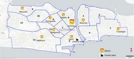
Map of Cotonou showing the districts and markets included in the study. The numbers 1 to 13 indicate the 13 districts of Cotonou.
2.2 Materials and methods
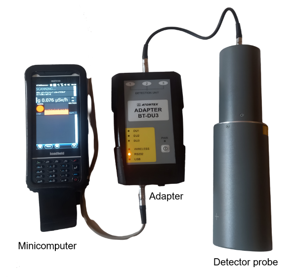
This is a cross-sectional descriptive and analytical study. The methodology involved measuring the ambient dose equivalent rate *(10) for gamma radiation at a height of one meter above the ground (referred to as the ambient gamma dose rate). The ambient dose equivalent H*(10) corresponds to the dose in a tissue at a depth of 10 mm and is used as a conservative estimate of the effective dose [13]. The measuring instrument used was the AT6101C(E) spectrometer from ATOMEX. It is equipped with a solid-state detector probe based on europium-doped strontium iodide (SrI2(Eu)), providing a typical energy resolution of 3.2% for cesium-137. The system also includes an adapter (Adapter BT-DU3) and a portable mini-computer, the Nautiz X8. The adapter transfers data from the detector to the mini-computer (Figure 2).
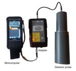
Photograph of the AT6101C(E) spectrometer used in this study to measure the ambient gamma dose equivalent rate.
The components of the device are integrated into a backpack. The AT6101C(E) spectrometer was factory-calibrated by the manufacturer using certified gamma reference sources. During fieldwork, the instrument was operated under standard conditions, and routine background checks were performed prior to measurements to verify its stability. The device simultaneously measures the ambient dose rate and GPS coordinates. It performs continuous scanning of gamma radiation, with real-time recording of dose rates and geographic data. An integrated mini-computer enables instant visualization of the collected data. Measurements were continuously conducted while riding on a motorcycle operated by a third party at a maximum speed of 30 km/h along the streets of Cotonou and on foot within the city’s markets. Measurements in the markets were conducted indoors, except at Dantokpa, an open-air market where they were performed outdoors. To facilitate route tracking, the Geo Tracker application installed on an Android smartphone was used, providing GPS tracks with a typical horizontal accuracy of 5–10 meters under open-sky conditions.
Data analysis was performed via ATAS Scanner© software, R (version 4.3.1), and Python (version 3.12). Descriptive statistics, including measures of central tendency and dispersion (average, standard deviation, first and third quartiles, and the 2.5th and 97.5th percentiles), were calculated for the ambient gamma dose rate. Maps were created on the basis of the GPS coordinates collected during field surveys. The coordinates are represented as scatter plots overlaid on a map background sourced from an OpenStreetMap shapefile and used solely for the geographic context of the points. A filter was applied to ensure consistency. Only measurements from the first visit to each location were retained, thereby avoiding bias from repeated measurements at the same locations.
The annual external effective dose (AEED) was estimated by extrapolating the average hourly dose equivalent rate over the duration of annual external exposure (t) via the following formula:
AEED = × 10-6 × t
where AEED is in millisieverts (mSv), is in nanosieverts per hour (nSv·h-1), t is the annual external exposure time expressed in hours (h); and the factor 10-6 is used to convert nSv to mSv.
This method aligns with the recommendations of the International Commission on Radiological Protection, which advocates the direct use of the ambient dose rate to estimate the effective dose for the public exposed to external gamma radiation [13].
For streets, an outdoor occupancy factor of 0.2 was assumed, according to UNSCEAR estimates [14], as they are located in residential areas; thus, t = 365 × 24 × 0.2 = 1,752 hours per year. For markets, the opening and closing hours of the indoor markets (9 a.m. and 9 p.m.) were used to determine the exposure time, yielding 12 hours per day, corresponding to t = 365 × 12 = 4,380 hours per year.
3. RESULTS AND DISCUSSIONS
3.1 Results
3.1.1 Extent of the Surveyed Regions
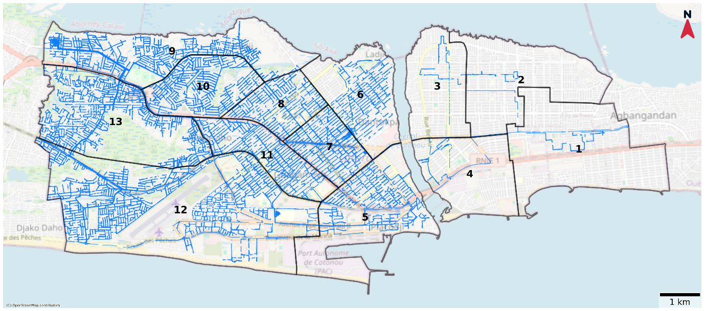
Figure 3 shows nearly exhaustive coverage of the western part of the lagoon area, which was achieved through a systematic street survey. The few uncovered zones mainly correspond to inaccessible depressions (lowlands) or street segments that were temporarily blocked due to ongoing construction work. In total, the dose rate was recorded at 341,991 points across all 13 districts, which represents 4,329 points per km2.
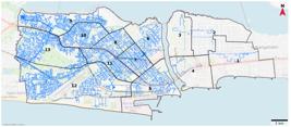
Street networks surveyed in the city of Cotonou. The surveyed streets are shown as thin blue lines, with almost complete coverage of districts 5–9 and partial coverage of districts 1–4.
All nine (09) markets included in the study were subject to a systematic and comprehensive scan, with a total of 16,202 points recorded.
3.1.2 Ambient Gamma Dose Equivalent Rate
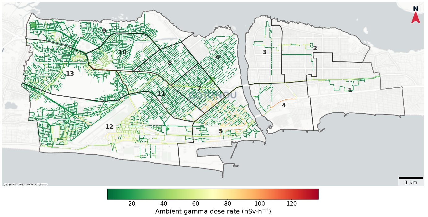
Along the streets, the average ambient gamma dose equivalent rate was 25.11 ± 12.72 nSv·h-1, with values ranging from 4.67 to 136.83 nSv·h-1. The spatial distribution of these dose rates across the districts of Cotonou is illustrated in Figure 4.
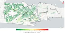
Map showing the ambient gamma dose equivalent rates along the street networks of Cotonou in 2024. The level of the ambient gamma dose equivalent rate along the streets is represented according to the color scale.
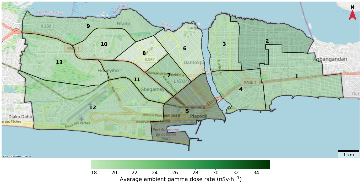
Almost all (97.4%) of the streets in Cotonou presented an ambient gamma dose equivalent rate in the green zone, indicating low dose rates (< 60 nSv·h-1). The average ambient gamma dose equivalent rate in the districts of Cotonou ranged from 17.72 ± 6.73 nSv·h-1 in District 8 to 35.37 ± 25.09 nSv·h-1 in District 5. The minimum ambient gamma dose equivalent rate was 4.67 nSv·h-1 and was observed in District 9, whereas the maximum dose rate reached 136.84 nSv·h-1 in District 5 (site of a cement manufacturing plant).
The distribution of the ambient gamma dose equivalent rates in the 13 districts of Cotonou is summarized in Table 1.
A map of the average ambient gamma dose equivalent rates in Cotonou districts is shown in Figure 5.
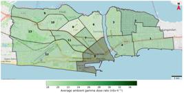
Map showing the average ambient gamma dose equivalent rates in Cotonou districts in 2024. The highest average rate was observed in District 5, which hosts a cement manufacturing plant.
In the markets of Cotonou, the average ambient gamma dose equivalent rate was 42.22 ± 28.23 nSv·h-1, with extreme values ranging from 7.38 to 156.10 nSv·h-1. The highest individual dose rate was recorded at the Gbégamey market, whereas the Midombo market presented the highest mean dose rate (83.17 ± 20.43 nSv·h-1). Table 2 presents the ambient gamma dose equivalent rate values for the nine markets in Cotonou.
The average ambient gamma dose equivalent rate in the indoor markets was 69.72 ± 21.96 nSv·h-1. The average ambient gamma dose equivalent rate in the indoor markets was more than double that of the Dantokpa market. The average dose equivalent rate was higher in the indoor markets (Aïdjèdo, Cadjèhoun, Ganhi, Gbégamey, Midombo, Menontin, Tokplégbé, Wologuèdè) than in their respective districts. The average ambient gamma dose equivalent rate in the Dantokpa market was close to that measured in the district where it is located. Figure 6 provides an overview of the average ambient gamma dose equivalent rate in each market, as well as in their respective districts.
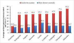
The difference in the average ambient gamma dose equivalent rate between the markets and their respective districts of location is shown in Figure 7.
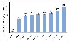
Differences in average ambient gamma dose equivalent rates between markets and their corresponding districts in 2024. The error bars represent the 95% confidence intervals of the average differences.
The difference in the average dose equivalent rate between the Dantokpa market and its district of location was significantly lower and distinct from that observed for the indoor markets and their respective districts.
3.1.3 Annual External Effective Doses
The average annual external effective doses ranged from 0.03 ± 0.01 mSv to 0.06 ± 0.04 mSv along the streets of the Cotonou districts (Table 3).
The average of annual effective dose was 0.10 ± 0.06 mSv for the Dantokpa market and ranged from 0.27 ± 0.09 mSv to 0.36 ± 0.09 mSv for the indoor markets (Table 4).
3.2 Discussion
The measurement of the ambient gamma dose equivalent rate along streets and in markets in Cotonou, southern Benin, provided valuable data on public external exposure to ionizing radiation. The data, derived from a nearly exhaustive survey of the study area, provide representative coverage of the city of Cotonou. The methodology, which is based on measuring the ambient gamma dose equivalent rate along streets, is particularly relevant, as these routes are frequently used by the population, whether on foot, by motorcycle, or by car. Moreover, this nearly exhaustive network enables the mapping of a large portion of the urban area, especially residential zones, through continuous and georeferenced data collection over long distances. Previous studies have adopted a similar approach. In Kenya, a study assessed natural radioactivity by measuring the ambient dose rate along a section of roadway in a laterite mining region on the southern coast [15]. In Egypt, another study included the Aswan-Abu Simbel highway in a campaign measuring the ambient dose rate in the southern part of the country [16].
In Benin, an earlier study measured the ambient gamma dose equivalent rate in the central part of the country, specifically in the Collines Department, with study sites in granite quarries and schools [11]. Similar studies have examined public areas in Nigeria [17], Burkina Faso [18], and Cameroon [19]. Other studies have focused on specific areas, including phosphate mines in Togo [20], gold mines in Burkina Faso [21] and Ghana [22, 23], and tin mines in Nigeria [24].
In the present study, the ambient gamma dose equivalent rate was measured directly in the air, following a similar approach to that used in certain studies conducted in Nigeria [17] and Benin [11]. However, this method differs from that used in several other studies, where dose rates were calculated from the activity concentrations of radionuclides in soil samples [25, 26]. While this indirect approach allows for the identification of specific radionuclides, it limits the geographic scope of the results to the sampling sites.
The measured values in Cotonou, along the streets, ranged from 4.67 to 136.83 nSv·h-1, with an average of 25.11 ± 12.72 nSv·h-1. These rates are significantly lower than those recorded in schools in the Collines Department, a mountainous area located approximately 220 km north of Cotonou, where ambient gamma dose rates range from 80 to 400 nSv·h-1, with an average of 250 nSv·h-1 (10). This difference is attributable mainly to the geological characteristics of the study areas, as mountainous regions tend to be naturally richer in radionuclides [14]. Similar values to those reported in Cotonou have been reported in Burkina Faso [18, 21], Nigeria [27], Cameroon [28], Algeria [29], and Sudan [30]. In contrast, higher dose rates have been recorded at specific sites, such as a phosphate mine in Togo [19], a gold mine in Ghana [31], and a coastal region in Madagascar [32]. The dose rate data reported by these authors are summarized in Table 5.
Outside the African continent, dose rate values also show considerable regional variability. According to UNSCEAR, the average absorbed dose rate in air ranges from 54 nSv·h-1 in Canada to 88 nSv·h-1 in Mexico, 66 to 103 nSv·h-1 in several European countries, such as Denmark, Finland and Lithuania, and between 68 and 104 nSv·h-1 in East Asian countries, including China, Indonesia, Japan and Korea [33]. However, such comparisons are limited by the heterogeneity of study sites and methodological approaches. As a result, these findings must be interpreted with caution, considering the specific geographical, environmental, and technical contexts of each study.
Spatial heterogeneity in dose rates was observed across the various districts of Cotonou, suggesting an uneven distribution of natural radioisotopes in the Earth's crust or the presence of specific anthropogenic sources, including naturally occurring radioactive material (NORM) industries. The relatively high average dose in District 5 may be attributable to the presence of a cement manufacturing plant located in this area [34].
At the open-air Dantokpa market, the dose rate was low and comparable to that of its host district. In contrast, in Cotonou’s modern market, which includes indoor facilities built and inaugurated in 2024, the ambient dose rate was higher than that in the surrounding districts, reaching nearly twice the district’s average dose rate. Indoor markets may favor the accumulation of radon due to limited ventilation and the possible use of construction materials containing elevated levels of uranium or thorium, as suggested by studies of radon exposure in public buildings [28, 34]. A study on granite from central Benin reported that the specific activity of natural radionuclides was greater than that of sand [35]. Furthermore, enclosed markets may contribute to increased indoor radon concentrations.
The estimated annual external effective dose on streets across various districts, as well as in Cotonou’s markets, remains below the UNSCEAR reference level of 0.87 mSv/year for public exposure to natural terrestrial and cosmic radiation [14].
Although ambient dose rates in markets remain below this threshold, further investigations would be relevant from an optimization perspective. In particular, studies on the radionuclide composition of construction materials and measurements of indoor radon activity concentrations, especially in enclosed public spaces, would also be justified.
4. CONCLUSIONS
This study provides representative data on ambient gamma dose equivalent rates across the city of Cotonou. The results indicate low levels of natural radiation exposure among the population, generally below the recommended public dose limits. However, the observation of higher dose rates in certain indoor markets highlights the need for greater attention to the construction materials used, especially in buildings open to the public. The relatively high dose rate in District 5, where the cement plant is located, underscores the importance of environmental radiological monitoring in areas potentially affected by NORM industries. In addition to the measurements performed, further investigations should be undertaken to assess the radiological composition of local construction materials and indoor radon concentrations. The findings of this study may serve as a reference for future research in Cotonou and surrounding areas and as a foundational tool for strengthening national public radiation protection and environmental health policies. They also highlight the need for broader environmental radiation monitoring strategies in other West African urban areas where radiological data remain sparse. Strengthening regional collaboration and data sharing could enhance preparedness and support evidence-based policymaking across the subregion.
The authors thank the Regulatory Body of Benin, the Autorité Nationale de Sûreté Radiologique et de Radioprotection (ANSR), for authorizing this study and for providing the AT6101C(E) spectrometer used to measure the ambient gamma dose equivalent rate. The authors are also grateful to Aristide Houndetoungan for his analytical support with the data analysis.
REFERENCES
-
1 PODGORŠAK, E. B. Modes of radioactive decay. In: PODGORŠAK, E. B. (Ed). Radiation physics for medical physicists. 2nd ed. Cham: Springer, 2016. p. 475–522. https://doi.org/10.1007/978-3-319-25382-4_11.
» https://doi.org/10.1007/978-3-319-25382-4_11 -
2 ASWAL, D. K. (Ed). Handbook on radiation environment, volume 1: sources, applications and policies. Singapore: Springer, 2024. https://doi.org/10.1007/978-981-97-2795-7.
» https://doi.org/10.1007/978-981-97-2795-7 - 3 IAEA. The ALMERA Network. Available at: https://www.iaea.org/sites/default/files/19/02/almera-network.pdf. Accessed on: 24 Sep. 2025.
- 4 NATIONAL ASSEMBLY OF BENIN. Law No. 2017-29 of March 15, 2018, on radiological safety and nuclear security in the Republic of Benin. Available at: www.ansr.gouv.bj. Acessed on: 10 Nov. 2024.
-
5 ICRP. The 2007 recommendations of the International Commission on Radiological Protection. ICRP Publication 103. Annals of the ICRP, Oxford, v. 37, n. 2–4, p. 1–332, 2007. https://doi.org/10.1016/j.icrp.2007.10.003.
» https://doi.org/10.1016/j.icrp.2007.10.003 -
6 TALAPKO, J.; TALAPKO, D.; KATALINIĆ, D.; KOTRIS, I.; ERIĆ, I.; BELIĆ, D.; MIHALJEVIĆ, V.; VASILJ, A.; ERIĆ, S.; FLAM, J.; BEKIĆ, S.; MATIĆ, S.; ŠKRLEC, I. Health effects of ionizing radiation on the human body. Medicina, Basel, v. 60, n. 4, p. 653, 2024. https://doi.org/10.3390/medicina60040653 .
» https://doi.org/10.3390/medicina60040653 - 7 UNSCEAR. Sources and effects of ionizing radiation: UNSCEAR 2010 report to the General Assembly with scientific annexes. New York: United Nations, 2010. Available at: https://www.unscear.org/unscear/uploads/documents/unscear-reports/UNSCEAR_2010_Report.pdf.
- 8 UNSCEAR. Sources, effects and risks of ionizing radiation: UNSCEAR 2020/2021 report to the General Assembly, with scientific annex C. New York: United Nations, 2022. Available at: https://www.unscear.org/unscear/en/publications/2020_2021_3.html.
-
9 WHO. Ionizing radiation and health effects. Fact sheet. Available at: https://www.who.int/news-room/fact-sheets/detail/ionizing-radiation-and-health-effects Acessed on: 10 Nov. 2024.
» https://www.who.int/news-room/fact-sheets/detail/ionizing-radiation-and-health-effects - 10 IAEA. Radiation, people and the environment. IAEA/PI/A.75/04-00391. Vienna: IAEA, 2004. Available at: https://www.iaea.org/sites/default/files/radiation0204.pdf.
-
11 ZINSOU, M. B.; HOUESSOUVO, C. R.; RABESIRANANA, N.; ALLODJI, R. S.; MEDENOU, D.; DOSSOU, J.; DE SOUZA, E. M.; MENSAHE, G. A. Gamma radiation dose rate measurements in granite quarries and schools in two mountainous towns in Benin. Brazilian Journal of Radiation Sciences, São Paulo, v. 12, n. 4, p. e2517, 2024. https://doi.org/10.15392/2319-0612.2024.2517.
» https://doi.org/10.15392/2319-0612.2024.2517 -
12 WORLD POPULATION REVIEW. Cotonou population in 2024. Available at: https://worldpopulationreview.com/cities/benin/cotonou Acessed on: 30 Dec. 2024.
» https://worldpopulationreview.com/cities/benin/cotonou -
13 ICRP. 1990 recommendations of the International Commission on Radiological Protection. Annals of the ICRP, Oxford, v. 21, n. 1–3, p. 1–201, 1991. https://doi.org/10.1016/0146-6453(91)90003-I.
» https://doi.org/10.1016/0146-6453(91)90003-I - 14 UNSCEAR. Sources and effects of ionizing radiation: UNSCEAR 2000 report to the General Assembly with scientific annexes. Volume I: Annex B. New York: United Nations, 2000. Available at: https://www.unscear.org/unscear/uploads/documents/publications/UNSCEAR_2000_Annex-B.pdf. Acessed on: 15 Jan 2025.
-
15 KANIU, M. I.; DARBY, I. G.; ANGEYO, H. K. Assessment and mapping of the high background radiation anomaly associated with laterite utilization in the south coastal region of Kenya. Journal of African Earth Sciences, Amsterdam, v. 160, p. 103606, 2019. https://doi.org/10.1016/j.jafrearsci.2019.103606.
» https://doi.org/10.1016/j.jafrearsci.2019.103606 -
16 SALAHEL DIN, K. Soil radioactivity levels and radiation exposure to the population in Aswan and Abu Simbel areas, south of Egypt. Physics and Chemistry of the Earth, Amsterdam, v. 127, p. 103179, 2022. https://doi.org/10.1016/j.pce.2022.103179.
» https://doi.org/10.1016/j.pce.2022.103179 -
17 ADEOJO, I. O.; ADEBISI, W. A.; ADEOJO, T. T.; ADEWUMI, O. F.; BABALOLA, K. K.; AZEEZ, S. O. Radiation mapping of Osun State, southwestern Nigeria, measuring the status of radioactivity. Fountain Journal of Natural and Applied Sciences, Osogbo, v. 2, n. 2, p. 30–37, 2023. https://doi.org/10.53704/fujnas.v12i2.471.
» https://doi.org/10.53704/fujnas.v12i2.471 - 18 YAMÉOGO, Z.; NABAYOOGO, D.; KABORÉ, O.; BANGOU, C.; ZEBO, I.; ZOUNGRANA, M. Measurements of natural radioactivity and exposure rates in soil samples from Ouagadougou, Burkina Faso. Journal of Materials and Environmental Science, Kenitra, v. 13, n. 1, p. 129–138, 2022.
-
19 ATEBA, J. F. B.; ATEBA, P. O.; BEN-BOLIE, G. H.; ABIAMA, P. E.; ABEGA, C. E.; MVONDO, S. Natural background dose measurements in South Cameroon. Radiation Protection Dosimetry, Oxford, v. 140, n. 1, p. 81–88, 2010. https://doi.org/10.1093/rpd/ncq035.
» https://doi.org/10.1093/rpd/ncq035 -
20 HAZOU, E.; SHOOUOP, C. J. G.; MEKONGTSO, E. J. N.; MOYO, M. N.; ATEBA, J. F. B.; TCHAKPELE, P. K. Preliminary assessment of natural radioactivity and associated radiation hazards in a phosphate mining site in southern area of Togo. Radiation Detection Technology and Methods, Singapore, v. 3, n. 16, p. 1–10, 2019. https://doi.org/10.1007/s41605-018-0091-x.
» https://doi.org/10.1007/s41605-018-0091-x -
21 NABAYOOGO, D.; OLIVEIRA, J. M.; CARVALHO, F. P. Environmental radioactivity in gold mining in Burkina Faso and potential recycling of mining waste rocks. International Journal of Environmental Studies, Abingdon, v. 79, n. 6, p. 1067–1077, 2021. https://doi.org/10.1080/00207233.2021.1978695.
» https://doi.org/10.1080/00207233.2021.1978695 -
22 DARKO, E. O.; FAANU, A.; AWUDU, A. R.; EMI-REYNOLDS, G.; YEBOAH, J.; OPPON, O. C.; AKAHO, E. K. H. Public exposure to hazards associated with natural radioactivity in open-pit mining in Ghana. Radiation Protection Dosimetry, Oxford, v. 138, n. 1, p. 45–51, 2010. https://doi.org/10.1093/rpd/ncp181.
» https://doi.org/10.1093/rpd/ncp181 -
23 FAANU, A.; ADUKPO, O. K.; TETTEY-LARBI, L.; LAWLUVI, H.; KPEGLO, D. O.; DARKO, E. O.; EMI-REYNOLDS, G.; AWUDU, R. A.; KANSAANA, C.; AMOAH, P. A.; EFA, A. O.; IBRAHIM, A. D.; AGYEMAN, B.; KPODZRO, R.; AGYEMAN, L. Radiological landscape of natural resources and mining: unveiling the environmental impact of naturally occurring radioactive materials in Ghana's mining areas. Heliyon, Amsterdam, v. 10, n. 13, e24959, 2024. https://doi.org/10.1016/j.heliyon.2024.e24959.
» https://doi.org/10.1016/j.heliyon.2024.e24959 -
24 ABBA, H. T.; SALEH, M. A.; HASSAN, W. M. S. W.; ALIYU, A. S.; RAMLI, A. T. Mapping of natural gamma radiation (NGR) dose rate distribution in tin mining areas of Jos Plateau, Nigeria. Environmental Earth Sciences, Berlin, v. 76, 208, 2017. https://doi.org/10.1007/s12665-017-6534-8.
» https://doi.org/10.1007/s12665-017-6534-8 -
25 MBONU, C. C.; BEN, C. U. Assessment of radiation hazard indices due to natural radioactivity in soil samples from Orlu, Imo State, Nigeria. Heliyon, Amsterdam, v. 7, e07812, 2021. https://doi.org/10.1016/j.heliyon.2021.e07812.
» https://doi.org/10.1016/j.heliyon.2021.e07812 -
26 BANGOU, C.; YAMÉOGO, Z.; HIE, K.; NITIEMA, E.; ZERBO, I; ZOUNGRANA, M. Assessment of natural radioactivity and radiological hazards in soil, sorghum, and water in Villy at the West Central Region of Burkina Faso. Applied and Environmental Soil Science, Cairo, v. 2024, p. 1–10, 2024. https://doi.org/10.1155/2024/2002878.
» https://doi.org/10.1155/2024/2002878 -
27 JOEL, E. S.; MAXWELL, O.; ADEWOYIN, O. O.; OLAWOLE, O. C.; ARIJAJE, T. E.; EMBON, Z.; SAEED, M. A. Investigation of natural environmental radioactivity concentration in soil of coastaline area of Ado-Odo/Ota Nigeria and its radiological implications. Scientific Reports, London, v. 9, 4219, 2019. https://doi.org/10.1038/s41598-019-40884-0.
» https://doi.org/10.1038/s41598-019-40884-0 -
28 SAÏDOU; TOKONAMI, S.; HOSODA, M.; TCHUENTE SIAKA, Y. F.; NDJANA NKOULOU, J. E.; AKATA, N.; OUMAR, B. O.; PENAYE, J. Natural radiation exposure to the public in the uranium bearing region of Poli, Cameroon: from radioactivity measurements to external and inhalation dose assessment. Journal of Geochemical Exploration, Amsterdam, v. 205, 106350, 2019. https://doi.org/10.1016/j.gexplo.2019.106350.
» https://doi.org/10.1016/j.gexplo.2019.106350 -
29 BRAMKI, A.; RAMDHANE, M.; BENRACHI, F. Natural radioelement concentrations in fertilizers and the soil of the Mila region of Algeria. Journal of Radiation Research and Applied Sciences, Amsterdam, v. 11, p. 49–55, 2018. https://doi.org/10.1016/j.jrras.2017.08.002.
» https://doi.org/10.1016/j.jrras.2017.08.002 -
30 ABDALHAMID, S.; SALIH, I.; IDRISS, H. Gamma absorbed radiation dose in Marrah mountain series, western Sudan. Environmental Earth Sciences, Berlin, v. 76, 672, 2017. https://doi.org/10.1007/s12665-017-6873-5.
» https://doi.org/10.1007/s12665-017-6873-5 -
31 FAANU, A.; ADUKPO, O. K.; TETTEY-LARBI, L.; LAWLUVI, H.; KPEGLO, D. O.; DARKO, E. O.; EMI-REYNOLDS, G.; AWUDU, R. A.; KANSAANA, C.; AMOAH, P. A.; EFA, A. O.; IBRAHIM, A. D.; AGYEMAN, B.; KPODZRO, R.; AGYEMAN, L. Natural radioactivity levels in soils, rocks and water at a mining concession of Perseus gold mine and surrounding towns in Central Region of Ghana. SpringerPlus, Berlin, v. 5, 98, 2016. https://doi.org/10.1186/s40064-016-1716-5
» https://doi.org/10.1186/s40064-016-1716-5 - 32 KALL, B.; DONNE, Z.; RASOLONIRINA, M.; RABESIRANANA, N. N.; RAMBOLAMANANA, G. Contribution à l’étude de la radioactivité gamma du sable des plages de Ramena et d’Orangea, Antsiranana, Madagascar. African Science, Cotonou, v. 10, n. 4, p. 23–35, 2014.
- 33 UNSCEAR. Sources and effects of ionizing radiation: UNSCEAR 2008 report to the General Assembly with scientific annexes (tables 6 and 12). New York: United Nations, 2010. Available from: https://www.unscear.org/unscear/uploads/documents/unscear-reports/UNSCEAR_2008_Report_Vol.I-CORR.pdf
- 34 IAEA. Protection du public contre l’exposition due au radon et autres sources naturelles de rayonnements dans un environnement intérieur. Safety Standards Series No. SSG-32. Vienna: IAEA, 2023. Available from: https://www-pub.iaea.org/MTCD/Publications/PDF/P1651F_web.pdf.
-
35 ZINSOU, M. B.; RABESIRANANA, N.; MEDENOU, D.; RASOLONIRINA, M.; GBAGUIDI, B.; MENSAH, G. A. Assessment of natural radioactivity (⁴⁰K, ²³⁸U and ²³²Th) and radiological risk in building construction materials: the case of Benin hill granites. Brazilian Journal of Radiation Sciences, São Paulo, v. 12, n. 4, e2530, 2024. https://doi.org/10.15392/2319-0612.2024.2530.
» https://doi.org/10.15392/2319-0612.2024.2530
Edited by
-
SCIENTIFIC EDITOR:
Prof. Dr. Bernardo Maranhão Dantas http://orcid.org/0000-0002-2388-6073
-
SCIENTIFIC EDITOR:
Prof. Dr. Alfredo Lopes Ferreira Filho http://orcid.org/0000-0002-0806-1284

 Source: Authors.Map of Cotonou with district boundaries and market locations labeled.
 Source: Authors.Backpack-mounted gamma spectrometer setup with detector, adapter, and portable computer.
 Source: Authors.Map showing surveyed street segments across Cotonou districts.
 Source: Authors.Map of street-level ambient gamma dose equivalent rate values across Cotonou.
 Source: Authors.District-level map of average ambient gamma dose equivalent rates across Cotonou.
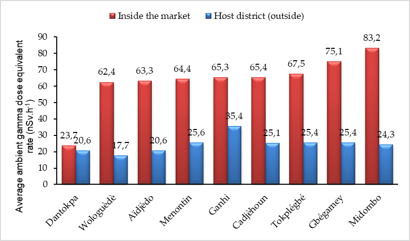 Source: Authors.Chart comparing average ambient gamma dose equivalent rates for markets and corresponding districts.
 Source: Authors.Error-bar chart of differences between market and district average dose equivalent rates.