
 Drones in Modern Construction: Resource Allocation, Inspection, and Regulatory Challenges
ABSTRACT
This review analyzes the integration, functionality, and regulatory environment of unmanned aerial vehicles. In this review, the role of drone technologies with advanced payloads, Red-Green-Blue, and infrared sensors to revolutionize the process of surveying, inspection, and safety monitoring by providing extremely high accuracy in real-time spatial data delivery is considered. The technologies are essential in increasing productivity, minimizing expenses, and decision-making in project management. Other than the technical capability, the paper discusses the international regulatory frameworks and governance models developed by agencies, including the Federal Aviation Administration, the European Union Aviation Safety Agency, the Directorate General of Civil Aviation, and the International Civil Aviation Organization. Even though such systems guarantee the security of the airspace and responsibility of the operators, the analysis indicates that the operations of UAVs between countries remain cumbersome as the loopholes continue to persist. The economic analysis shows that there is a high return on investment in the form of less time spent in the survey, lower labor expenses, and better safety results. Further research should be oriented to artificial intelligence-related data analytics, autonomous UAV swarm control, and automatic connection to building information modelling to allow real-time monitoring of the project and predicting its maintenance requirements.
Keywords
Drones; Aircraft construction; Geometric; Mission; Aerial photography; Mining
INTRODUCTION
To create an evidence-based and systematized basis, an exhaustive literature review was conducted to address the studies that were published within the range of 2010 and 2025 regarding the application of drones to the construction sector. The relevant literature was identified in major academic databases, including Scopus, Web of Science, ScienceDirect, and Google Scholar, using specific keywords such as drones in construction, unmanned aerial vehicle (UAV) applications, construction monitoring, aerial surveying, Light Detection and Ranging (LiDAR) mapping, and building information modelling (BIM) integration. Approximately 150 publications were found in the initial search, including journal articles, conference proceedings, and technical reports. The relevant and contributing studies to the topic were then selected after a careful screening procedure, and 79 studies were chosen. The inclusion criteria focused on research that explicitly addressed practical, technological, economic, or safety-related factors of drone applications in the construction industry. Articles that discussed only non-construction applications of UAVs, such as those in military activities or the use of remote sensors, were excluded. A systematic analysis of the selected literature was conducted, revealing the primary applications, operational advantages, challenges, and research gaps. This methodological approach will ensure that the review provides a balanced, up-to-date, and well-supported examination of how drone technology is transforming contemporary construction practices.
The UAV is a drone that is operated remotely or independently and without a human pilot (Harvey et al. 2016). They are in a position to perform different tasks equipped with cameras, communication systems, and sensors. Drones are used in multiple sectors, including agriculture, surveillance, disaster management, and delivery services. They are guided by the Global Positioning System (GPS) and use modern technologies, including artificial intelligence (AI), to achieve greater performance (Liu et al. 2017). The increasing popularity of drones is informed by their capability to reach distant locations, minimize the risk to human beings, and conduct activities effectively and cost-effectively. The drone is a highly developed technique for capturing real photos of the Earth’s surface (Zhang et al. 2019). Drones with a certain distance and little drones that fly a distance-specific boundary. Drones are remotely operated aeronautical machines for transporting deadly or non-deadly cargoes. Drones are classified into some categories according to their functionality, use, and design. In terms of design, they are separated into fixed-wing drones, which resemble aeroplanes, and rotary-wing drones, such as quadcopters, which are more efficient in long-range flights and offer better maneuverability (Tatum and Liu 2017). Depending on their size, drones will include nano-drones that can be used indoors or in small spaces, surveillance missions for huge UAVs in defence and cargo transportation. Functionally, they are remotely piloted, autonomous, and hybrid drones, which possess both capabilities. Commercially, there are agricultural drones, drones for photography and delivery, and military drones for surveillance and combat (Ding et al. 2023). Some drones are further categorized by size, where short-range UAVs are deployed for local monitoring and long-range UAVs (Radoglou-Grammatikis et al. 2020).
UAVs are used when carrying out large missions. Environmental applications utilize aerial mapping drones, while First-Person View (FPV) drones are commonly used in racing and entertainment applications. These classifications help determine the appropriate type for various missions based on flight time, payload, and operational requirements. Developments in production, routing, remote control, and force stockpiling frameworks have enabled the deployment of a wide range of drones in various situations where human proximity is problematic, impossible, or dangerous. The automation’s size and type of gear vary depending on their flight missions.
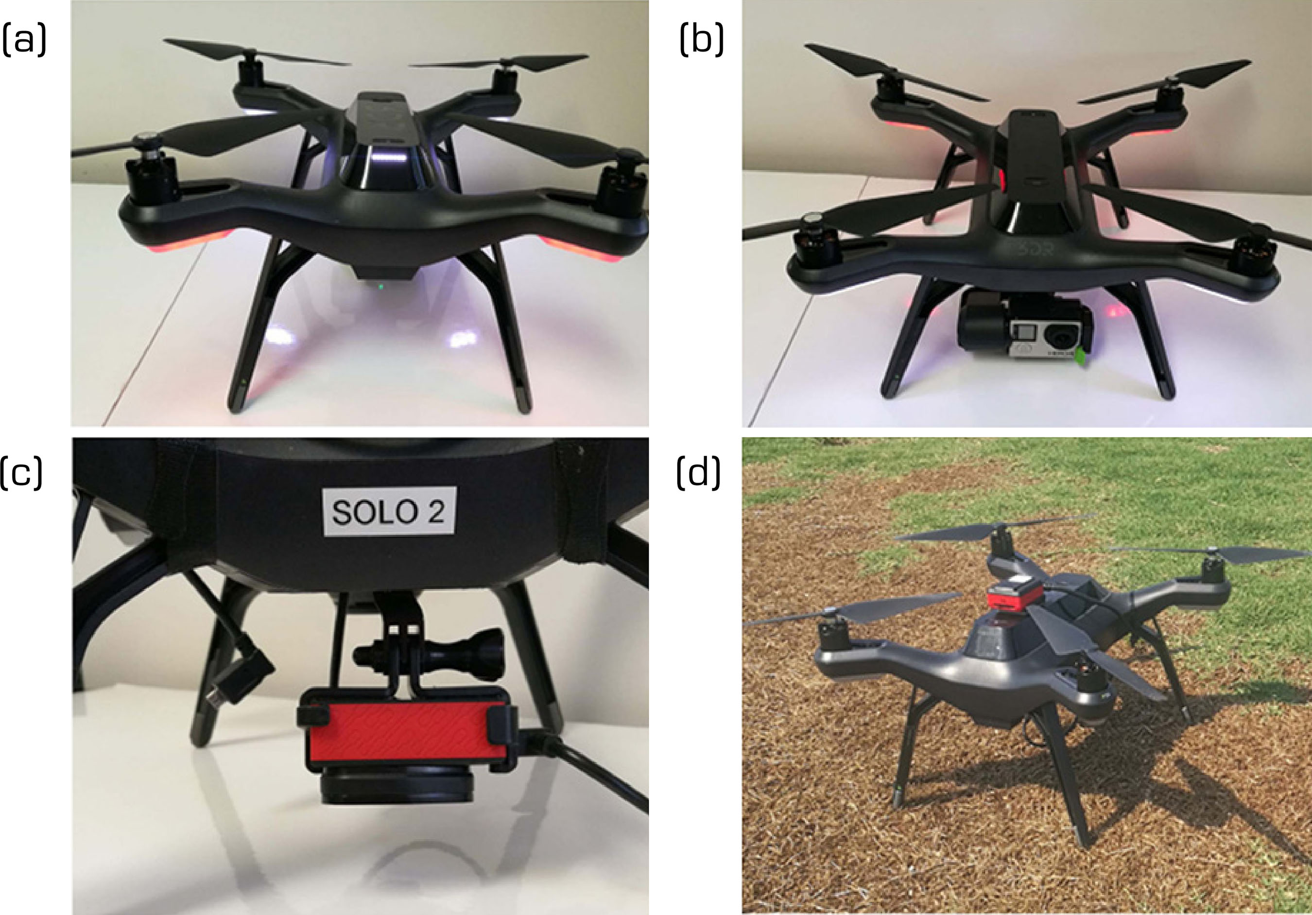
The best possible design for the automata encompasses materials required for the production of the physical UAV, chipsets, circuit sheets, and computing, which serve as the brain behind the automation, all of which are covered by UAV innovation. It features a UAV, gimbal, camera, and some of the most cutting-edge automation technology. Drones are provided with different cutting-edge technologies, like infrared devices, GPS, and lasers (buyer, business, and military UAVs). Remote ground control systems (GCS) limit drones (Ashraf et al. 2018; Guerra et al. 2018; Harvey et al. 2016; Kangunde et al. 2021; Sandino et al. 2020). Figure 1 depicts the many perspectives of a drone (UAV).
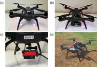
UAV. (a) Drone’s back view; (b) The Giro RGB camera on the front view; (c) Parrot Sequoia Multispectral camera mounted on a UAV; (d) Drone waiting to take off.
Drone regulations and operations in India
The Ministry of Civil Aviation implemented the first guidelines for flying drones in India on August 27, 2018, making the operation of UAVs legal. Additionally, it advises consumers to be aware of the limitations of aviation. Some essential guidelines and regulations are as follows:
-
The UAVs should be registered, given a unique identification number (UIN), and certified as airworthy.
-
The foreign trade directory should regulate the import of components.
-
They should not fly the craft vertically above 400 feet.
-
The UAVs should not be deployed in no-fly zones.
Drone fly zones and eligibility for a remote piloting license
Aircraft are not allowed to operate in No-Flying Areas, which include sites adjacent to airports, international fringes, Vijay Chowk in Delhi, state secretariats in national capitals, key locations, and army bases. Documenting a flight schedule and acquiring unique resistance to air, getting clear/flight data focus extension are used to obtain permission to operate in regulated airspace. The yellow zone is the space 400 feet above the green area. Ranges differ regarding the airport’s perimeter (200 feet above the region within an airport’s 8-12 km perimeter). The red zone is a “NO-drone fly” zone. Drones can only fly after obtaining prior permission from the relevant air traffic monitoring board (Majumdar and Tavawalla 2021). However, no approval is needed in the green zone to fly a drone. A person applying for a remote pilot license should have completed grade 10 or have an equivalent qualification. They must complete the necessary training provided by the Director General of Civil Aviation or the relevant control board. They should be within the age range of 18 to 65 years.
Drones regulations at the global level
At the international level, the central role of harmonization of regulations of drones is taken by the International Civil Aviation Organization (ICAO), a specialized United Nations agency. ICAO issued recommendations about how Remotely Piloted Aircraft Systems could be incorporated into civil airspace, so that they could be compatible with manned aviation. The structure of the organization focuses on the safety of operations, certification of airworthiness, communication, and the competency of pilots. Even though ICAO has no direct jurisdiction over domestic drone operations in individual countries, its standards can be used by national civil aviation authorities to design similar and mutually compatible regulatory policies.
In the United States, all activity is regulated by the Federal Aviation Administration (FAA). The Part 107 rule by the FAA provides certain conditions of commercial use of drones, such as certification of pilots, restrictions on operations, and registration protocols. Such regulations ensure a visual line of sight, flying below 400 feet above ground level, and not flying over people or restricted zones without approval. Another safety measure introduced by the FAA is the Remote Identification (Remote ID) rule, which allows the authorities to detect and monitor drones in real time to provide security and accountability.
The European Union Aviation Safety Agency (EASA) has seen the development of a single regulation structure that is applicable to all European Union member states. The system of EASA can be categorized into three types of drone operations (open, specific, and certified) that are determined by the degree of risk. The open category permits low-risk operations with severe restrictions, and the specific and certified categories involve further operations authorization and risk evaluation. This unified methodology makes the European Union-wide consistent and provides cross-border drone operations in the area.
Transport Canada (TC) Civil Aviation imposes drone regulations in Canada under Part IX of the Canadian Aviation Regulations. These regulations differentiate the basic and advanced operations by proximity to individuals and the regulated airspace. The operators will be required to acquire a drone pilot certificate and register drones that have a weight between 250 g and 25 kg. Likewise, the Civil Aviation Safety Authority (CASA) of Australia also requires the accreditation of drone operators or the licensing of a remote pilot, depending on the purpose and size of the drone, which underscores the importance of safety awareness and airspace control.
In Asia, regulatory systems vary significantly. The Chinese market, which is among the largest in the world, has real-name registration of all drones, which must be registered, and pilots are required to obtain a license to operate professionally. The Civil Aviation Authorities of Singapore and the Directorate General of Civil Aviation of India (DGCA) have also devised detailed regulations concerning the types of operations, pilot certification, and airspace permission using digital platforms like the DigitalSky system in India.
In general, drone regulation at an international scale is an area that has been dynamic and changing. Although most nations have come up with strong frameworks, complete international harmonization remains a challenge to cross-border drone operations. It is also vital to continue international cooperation under ICAO and regional aviation organizations, which should facilitate the formulation of standardized, interoperable policies that promote safe and sustainable integration of drones into global airspace. Table 1 provides the drone regulations followed in different countries.
Classification of drones
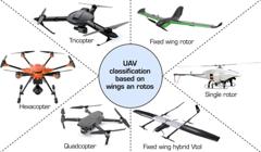
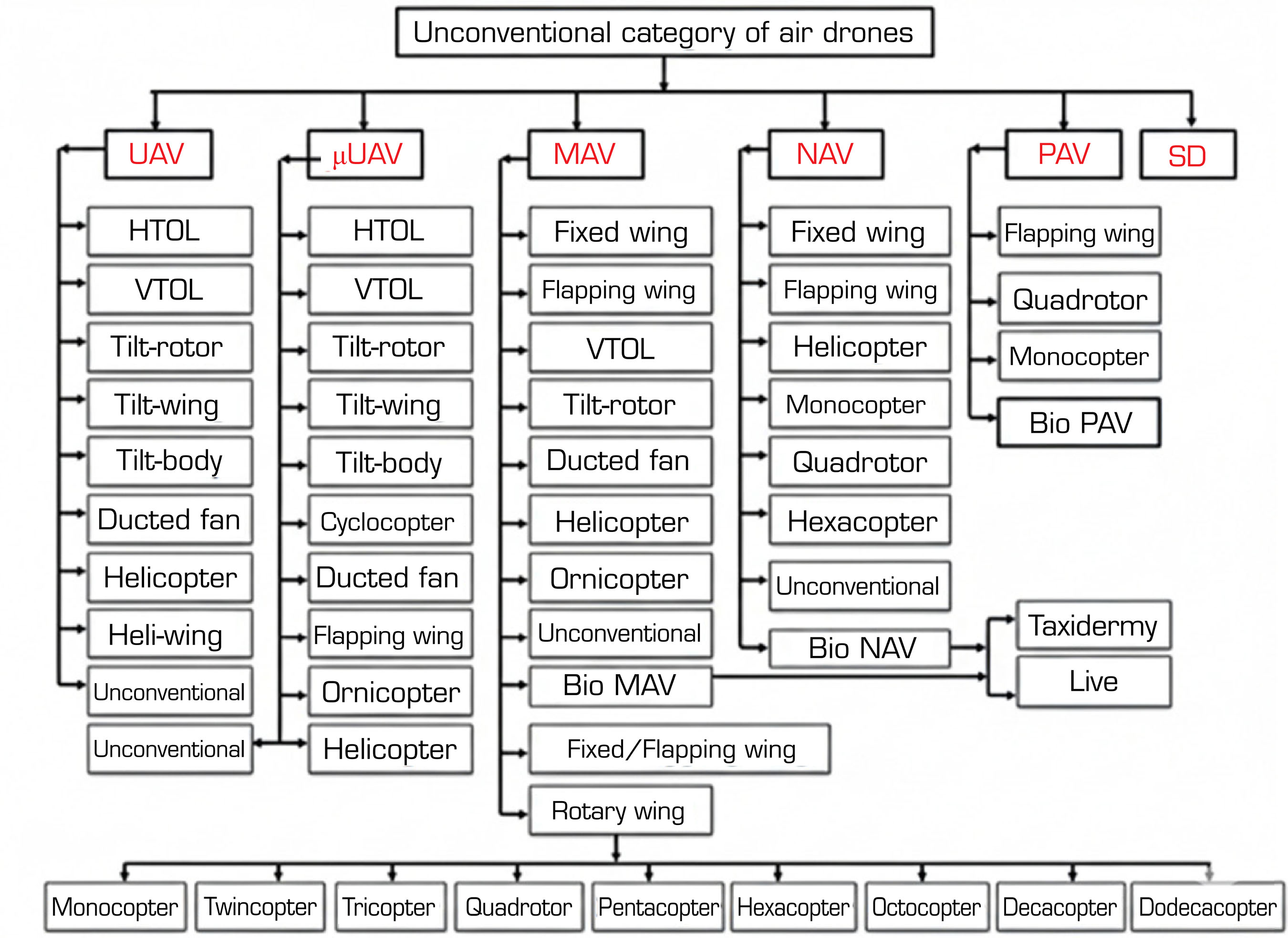
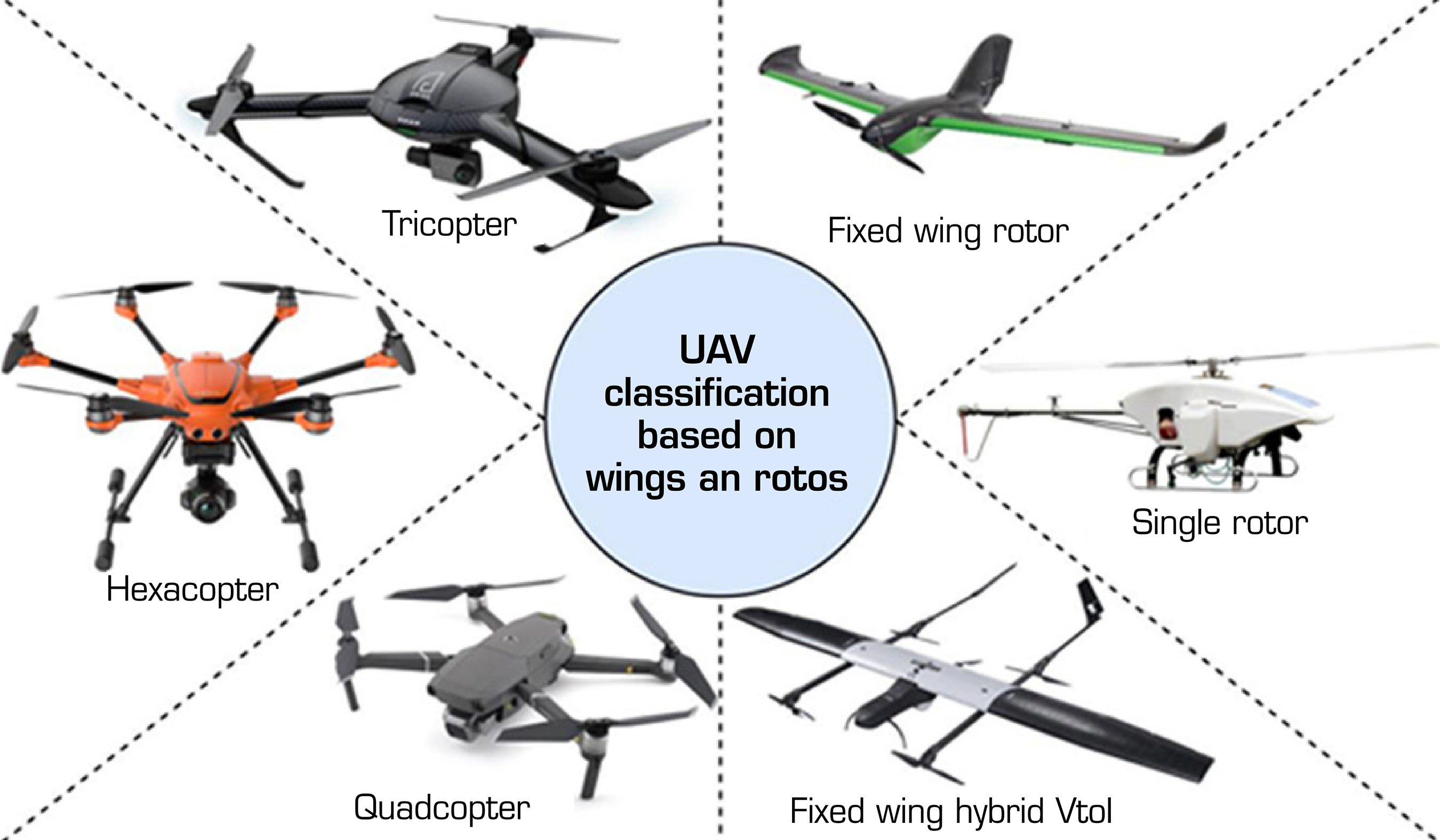
Drones are classified in various ways (Fig. 2). The advancement of smaller flights, known as small-scale air vehicles, has increased the demand for knowledge missions in recent decades. Incredible effort is being made to design and create short flights for innovative missions; these endeavors result from the advancement of several small drones with various shapes and flight styles. A detailed description of modern automation includes horizontal take-off and landing (HTOL). Typically, drones are identified by their operational capabilities. The primary design factors that determine and select drones with beneficial class structures are weight, wing length, and wing stacking, as well as extreme altitude, speed, industry readiness, design, and costs. Furthermore, automation can be built around their motors. UAVs, for example, are occasionally used to monitor gasoline motors, whereas micro air vehicles (MAVs) utilize electric vehicles. Structures that can be employed in flights are unique and are determined by their models. Based on their rotors and wings, UAVs are categorized into different types, as shown in Fig. 3. The configuration of the drone provides detailed design capabilities in its setup. The flowchart considers the biodesigns of small-sized and nano air vehicles (NAV), characterized as live, controllable winged animals or bugs and flying feathery creatures (Gonzalez-Aguilera and Rodríguez-Gonzalvez 2017; Kardasz and Dosckocz 2016).
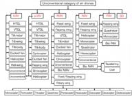
Horizontal take-off and landing and vertical take-off and landing UAVs
There are four conditions for UAVs after multiple breakthroughs in HTOL flight ambles, which incorporate methods of lift/mass dependability and methods for strength and control. Tail-behind blasts, tailless or flying-wing UAVs, and tail planes positioned ahead or behind are options. Driven structures on the back of the fuselage or the front of the UAV are common in prominent designs. Steady-wing vertical take-off and landing (VTOL) drones feature cross-wings and usually have a vertical impetus device on the front of their fuselage. These drones can take off and land vertically, eliminating the need for runways (Alarcón et al. 2020).
Helicopter and heli-wing UAVs
Scientists have developed unmanned helicopters for vertical take-off, landing, and hovering flight. The four types are single-rotor, coaxial-rotor, pair-rotor, and quad-rotor helicopter UAVs (Liu et al. 2017; Valavanis and Vachtsevanos 2015). Heli-wing drones have numerous kinds of drones with a revolving wing as their cutting edge. They may fly vertically, like a helicopter, and also as a fixed-wing UAV (Joshi 2015; Schauwecker et al. 2012).
Constant/flapping wing MAVs
A fluttering wing for a smaller-scale air vehicle was developed after investigating the streamlined characteristics of low Reynolds numbers and the fluttering wing drive. Fixed-wing MAVs are a hybrid of fixed-wing and flapping-wing designs, combining flight and propulsion capabilities. A trailing set of folding, fluttering wings and a low-segment steady wing make up the automation in this type of small-scale air vehicle. By entraining float, the fluttering wing component will increase productivity, provide routine, effectively adjust the stage, and eliminate slowing over the steady wing. This type of automation is based on a dragonfly with two wings that supply and push power.
Rotary wing MAVs
Compared to other drones and UAVs, one of the primary advantages of MAVs is their smaller size, which allows them to fly in restricted areas (Charavgis 2016). This is especially true for revolving-wing MAVs, which can hover and move quickly (Papageorgiou et al. 2018; Radoglou-Grammatikis et al. 2020). Turning-wing flights are defined by revolving sharp edges or propeller-based frameworks. Unlike fixed-wing aircraft, these drones can fly in all directions, both horizontally and vertically, and drift in for a specific mission. These characteristics make them the most suitable drones for covering difficult-to-reach locations, such as pipelines, spans, and other structures (Hassanalian and Abdelkefi 2017). The continuous rotation of the rotor’s sharp edges produces lift in flight, similar to that of helicopters. Various sharp edges are used in such MAVs. From one to 12 cars, scientists have constructed remarkable drones.
Bio-drones
New methods were considered due to the significance of observation common to both civil and military applications. Occasionally, noteworthy drones are designed and created to complete specific missions. Miniaturized flights with smaller dimensions and loads should appeal to the armed forces. There are particular procedures for planning and manufacturing small drones. Such systems are based on feathered creatures and bugs. Different systems recommend using live or dead winged creatures and bugs for observation and monitoring of various missions (Biggs et al. 2016; Dheeravath et al. 2010). In this manner, bugs or flying creatures that might be controlled with electrical chips might be used. Specific styles of bio-drones can be referred to, and bio-flights fall into two classes: taxidermy and stay flights.
Applications of drones in the construction sector
Structural and infrastructure inspection in the construction industry
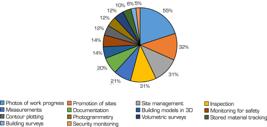
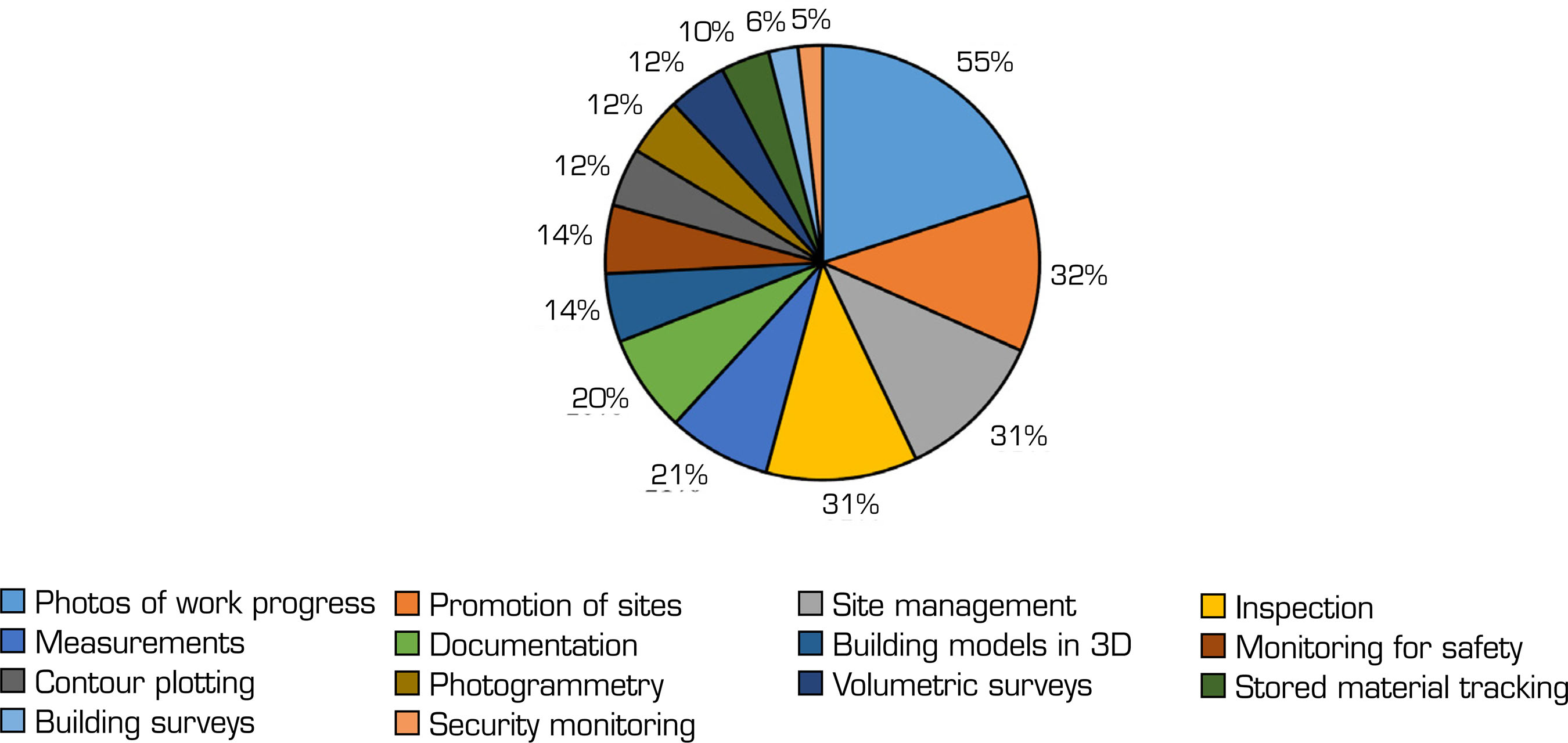
Figure 4 depicts the various applications of drones in the building sector. The labor shortage is increasing rapidly in the industry, and utilizing available engineering expertise to monitor structural and infrastructural work is not easy. Scientists have recently examined UAVs conducting auxiliary and foundational investigations. These appraisals secured structures and spanned several systems (e.g., holding dividers, streets, windmills, and dams). In construction sites, aerial drones have been employed for various tasks, including construction monitoring, surveying and mapping, power transmission lines, drainage and erosion control, environmental monitoring, emergency services, traffic monitoring, wind turbine inspections, highway inspections, inspecting roads, bridges, high-mass lighting, cell towers, and building façade inspections.
The UAVs provide vital support and cost savings by offering expansive views of remote and otherwise difficult-to-reach locations (Aiyetan and Das 2023; Nwaogu et al. 2023; Onososen et al. 2023; Regona et al. 2024; Van Wyk et al. 2024). Expanding this comparison beyond construction schedule and costing, including planning, billing, recording real-time cases, verification, and reporting, is possible. Due to their advanced automation, UAVs can now access previously inaccessible areas and rapidly collect vast amounts of data. Aerial drones used in the construction sector with multiple applications are shown in Fig. 4, and drone types and payloads for different applications in the construction sector are presented in Table 2.
Land surveying and mapping
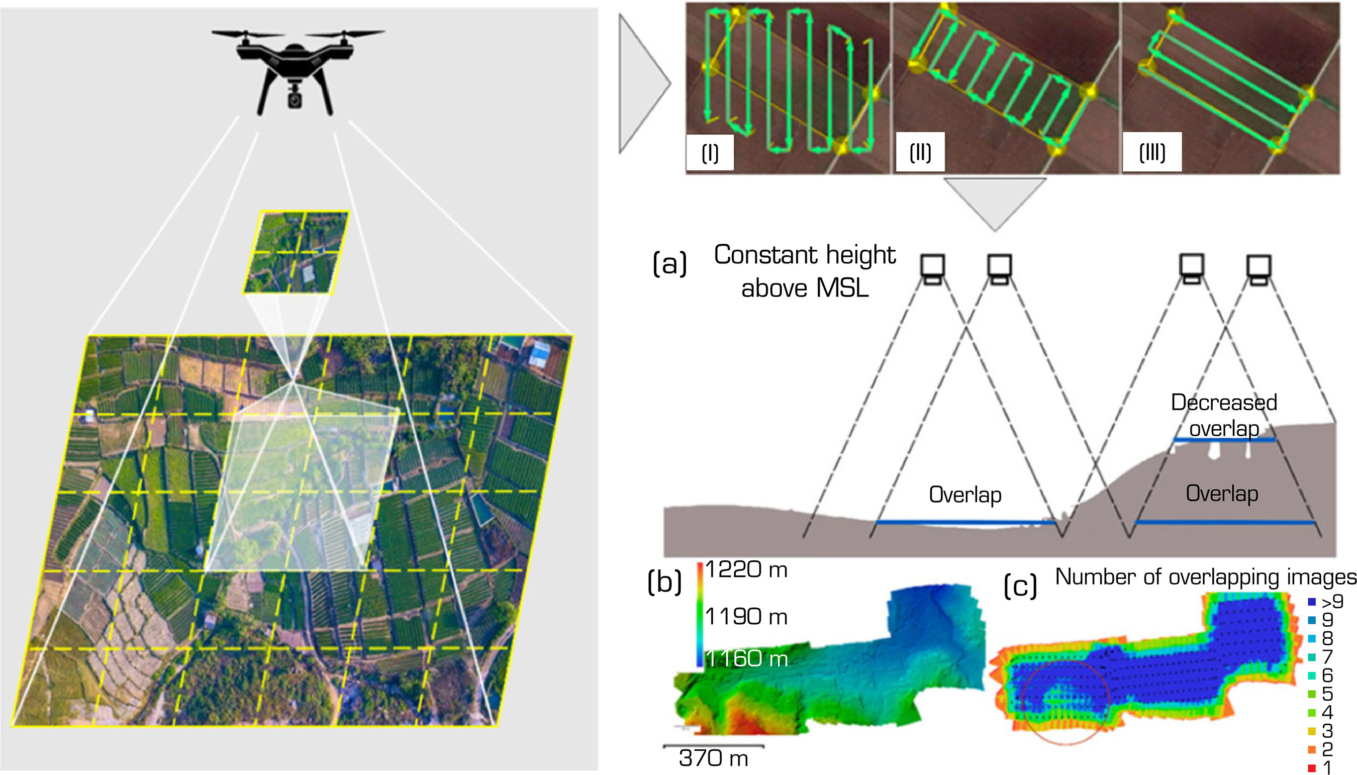
Helping to deliver significant advantages compared to traditional methods of surveying and mapping construction sites, drones are transforming land surveying and providing essential information to the construction and design process. Employing drones on construction sites provides an aerial or eagle view of the site with high-resolution images. The exact boundaries, structure, and topography of the site data are collected using heat sensors (Giordan et al. 2020) and LiDAR (Kim et al. 2019). By using exact elevations, contours, and distances, it is possible to prepare accurate calculations and develop complex 3D models. Drones are also helping in the development of control points for surveying, which provides more reliability and accuracy, and is georeferenced precisely. Drone mapping encompasses aerial photography and photogrammetry, which are methods for developing precise visualizations and simulations of the building site (Ajayi et al. 2018). Drones have the capability of flying around large areas, capturing aerial images with high levels of resolution, which visually present the features of the site. Photogrammetry algorithms are used initially to scan the overlapping photographs to generate two-dimensional and three-dimensional maps, such as topographic drawings of elevations, contours, slopes, and other topographic features (Chesley et al. 2017). By piecing together multiple photos, orthomosaic maps provide geometrically correct and accurate depictions of the location, making it easier to measure precisely, calculate distances, and conduct visual analysis (Lee et al. 2023; Lu et al. 2023; Muhmad Kamarulzaman et al. 2023; Sestras et al. 2025). Figure 5 illustrates the use of a drone to create topography in a digital model.
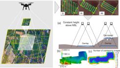
Process of generating terrain in a digital model with a drone. (a) Decreased overlap in hilly terrain; (b) Digital terrain model generated; (c) The number of overlapping images.
Building inspection
UAV applications are relevant for examining buildings. Nonetheless, execution and security were insufficient (Halder and Afsari 2023; Huang et al. 2023; J. Li et al. 2023; Lyu et al. 2023; Staffa Junior et al. 2025; Wang and Ueda 2023).
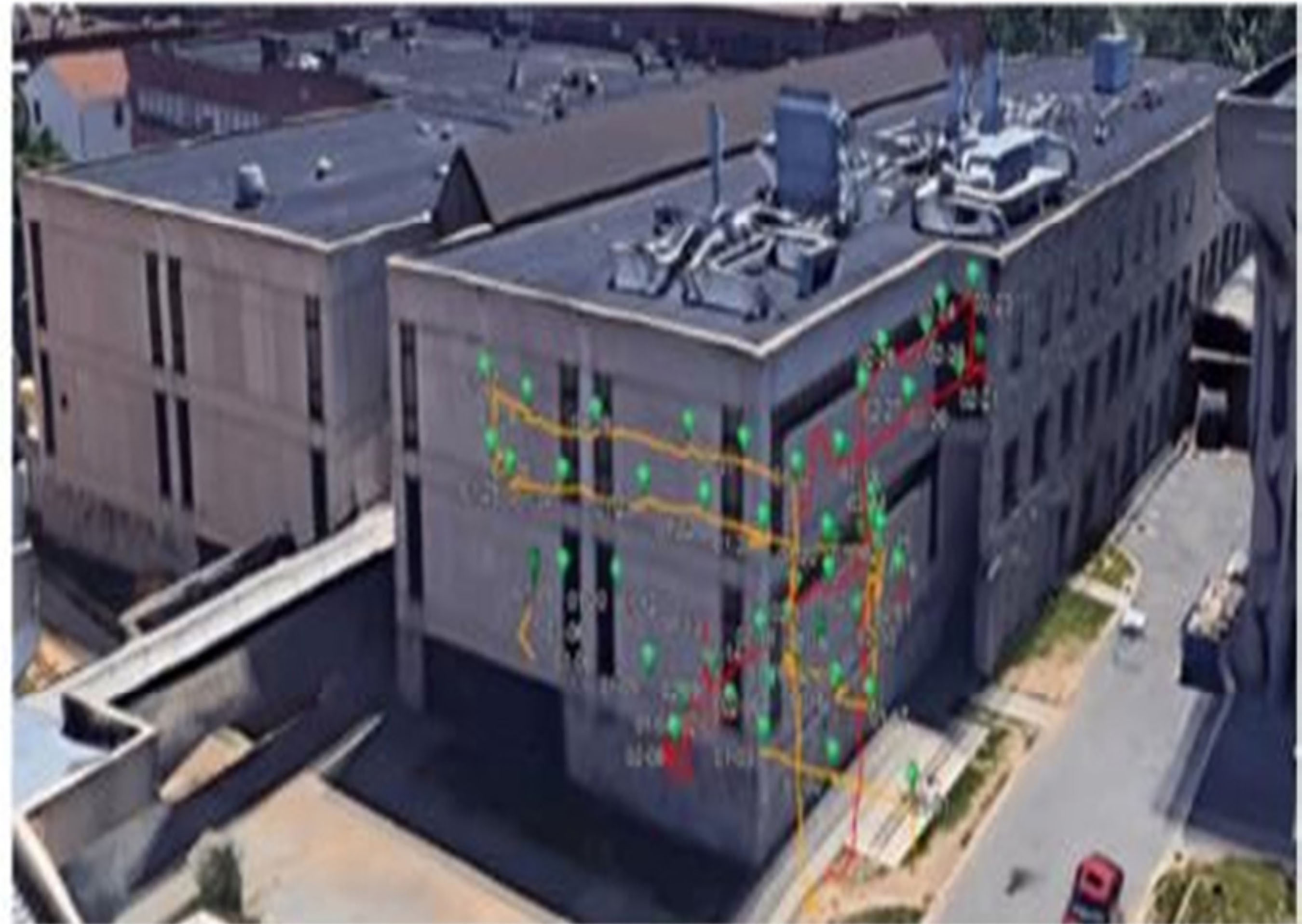
Various examinations depend on light detection and LiDAR procedures to conduct similar investigations. The application recreates a computerized 3D model of a building using UAV-provided images. Benchmark datasets were used to evaluate the results, which showed an impressive model that resembled the LiDAR study process. The UAV designers revealed high-quality outcomes that could be utilized for quality and basic investigations. Figure 6 illustrates the inspection mission using UAVs.
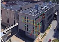
Bridge inspection
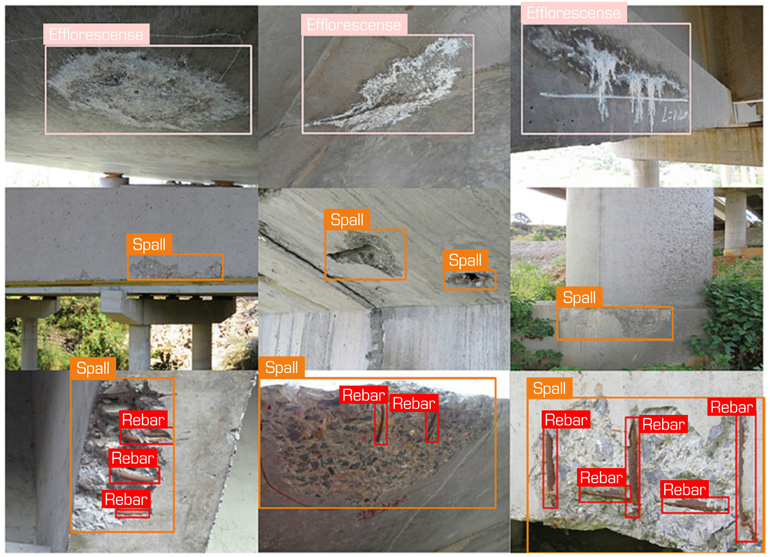
The UAV-connected assessment is completed using UAV-provided multispectral photos, which employ Red-Green-Blue (RGB) cameras to minimize weakening side effects in street-connected decks (Cardellicchio et al. 2023; R. Li et al. 2023; Luo et al. 2023; Yamane et al. 2023). Regarding their discoveries, this non-contact time identifies and limits splits and delamination. In other investigations, territory tests on spans lead to assessing a proposed automatic split discovery and width estimation (Kim et al. 2011). Regardless of variations between the estimated and dissected split widths, the investigations contended that such errors were within the permissible range of 1 mm.
Furthermore, utilizing UAV-captured and PC-processed images helped examine the supervisor’s level of connection injuries. A most recent examination assessed the adequacy of UAVs as a beneficial scaffold measurement instrument. By growing a 4-degree UAV-empowered timber curve connect for evaluating a photograph’s best appraisal, the designers found that their procedure was accurate and precise, with some variation in the impact recovered regarding break length, thickness, and rust stain placement compared to conventional field estimations. Figure 7 depicts the bridge inspection using drones.
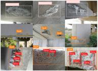
Safety monitoring during construction
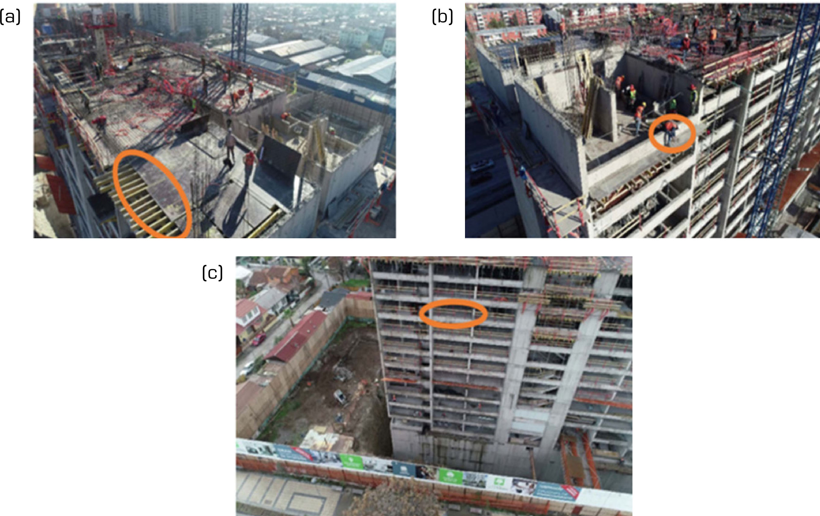
Drones, along with sensors, a high-resolution camera, and the provision of data processing, provide a lot of benefits for construction monitoring in the aspect of safety, which includes the capacity of recording videos and capturing high-resolution images that can identify the conditions such as unstable structures, equipment failure, wastes generated at sites, and non-use of protective equipment during the execution (Anwar et al. 2018; Feroz and Abu Dabous 2021; Gupta and Nair 2023; Patrick et al. 2020; Szóstak et al. 2023; Umar 2021). The inspection person can identify any hazards, assess the site’s overall safety, and take the necessary precautions from a bird’s-eye view (aerial). Figure 8 shows the aerial image of building construction (construction project in Santiago, Chile) captured for safety monitoring.
Traffic surveillance and monitoring
UAVs are utilized for site traffic reconnaissance and checking drone upgrades to assist with traffic management. The common sense of five UAV photograph datasets for guest float and car checking has been broken down by methods for offering a low-altitude vehicle detection technique. Despite experiencing vegetation obstructions, such as perceiving timber as cars, they achieved a recognition accuracy of 64%, and they suggested using this proposed strategy in this unique situation. Figure 9 depicts traffic monitoring using drones. UAV flights have been utilized for avalanche observation and mapping, estimating earthwork volumes, and traffic observation.
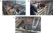
UAV images for safety monitoring at a construction site in Chile. (a) Lack of guardrails; (b) Worker without a safety rope; (c) Lack of guardrails.
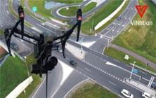
For avalanche checking and earthwork, UAV strategies were employed to produce virtual terrain models, similar to orthomosaics, which were compared with conventional observation techniques, including earthbound laser scanners, geodetic GPS collectors, and tachymetry. Other research did not involve such examinations, yet was competent, through UAV photogrammetry, to accomplish quantifiable 3D models. Drone photos and recordings were also a viable traffic observation technique (Ali 2019; Gohari et al. 2022; Gupta and Verma 2021; Prabu et al. 2022).
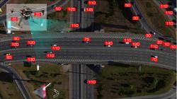
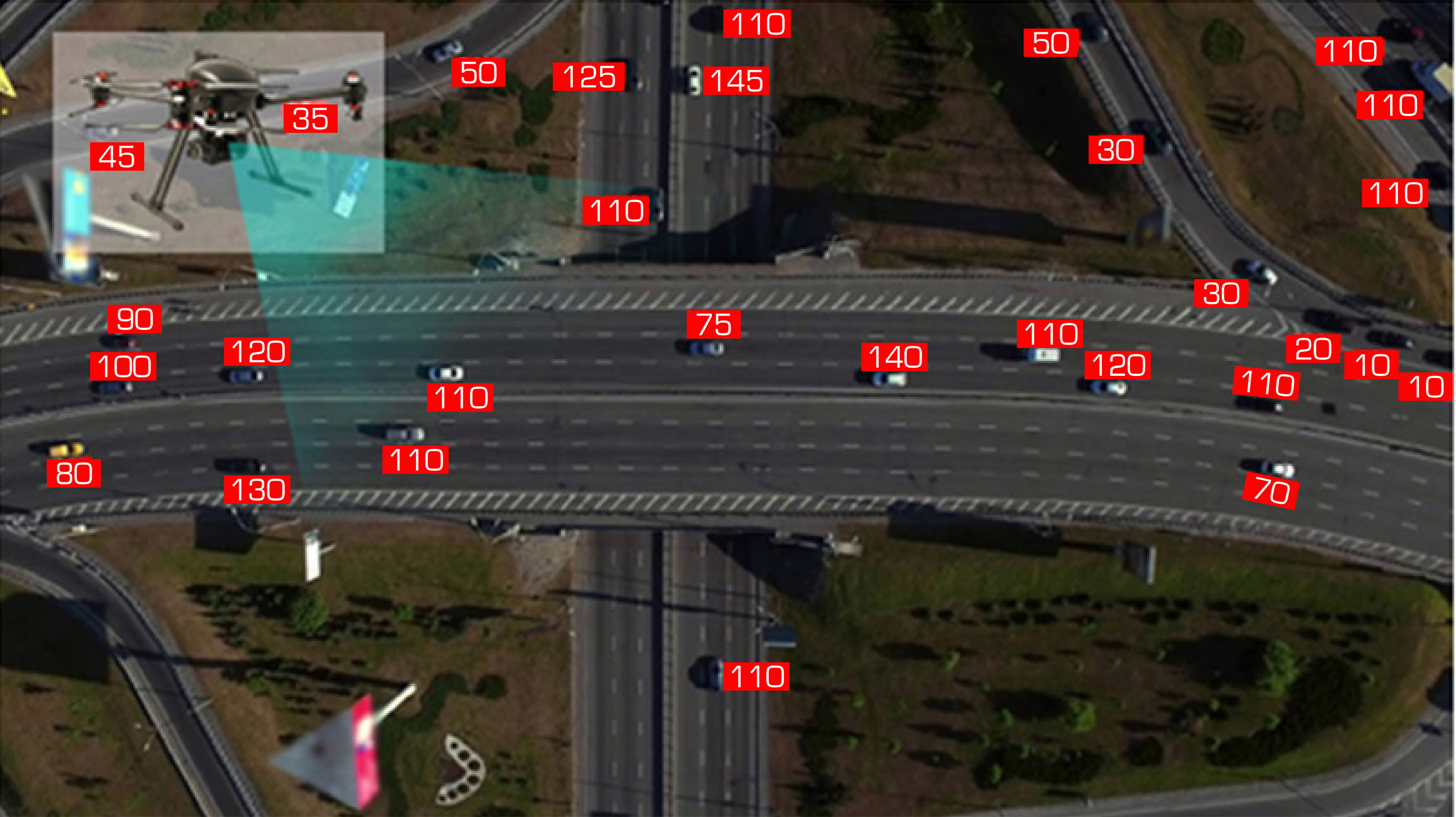
In any case, a single glance at the utilization of various UAVs for significant enhancements in guest reconnaissance. Inconveniences affecting the results of the investigations included atmospheric and lighting apparatus conditions, which affected the UAVs’ overall performance, as well as greenery obstructions that favored the prominence of trees over cars. Future research is justified in assessing the utilization of numerous drones for guests, improving the efficiency of the applied algorithms, and enhancing the stages’ products and equipment to manage natural conditions and vegetation impediments (Rojas Viloria et al. 2021). Figure 10 shows the speed of vehicles and lane tracking using drones.
Drones in mining
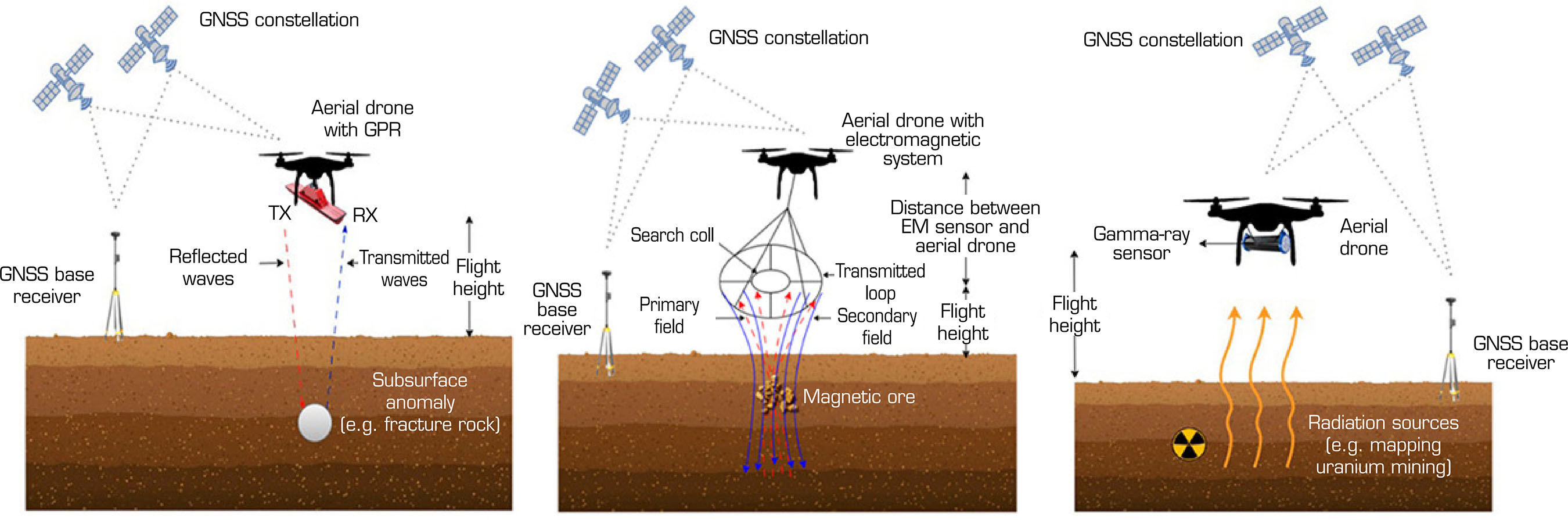
Application of drones in mining includes a topographic, underground mine, and aerial surveying during the exploration phase; analysis of structure, geological, and work environment, and monitoring of ecological restoration in the exploitation phase; pollution control, ground subsidence monitoring, and analysis of rock slope during reclamation (Perikleous et al. 2025; Said et al. 2021; Shahmoradi et al. 2020). Studying the application of UAVs in mining offers the advantages of manageable and low-cost operations, accurate and high-resolution data acquisition, and ultimately, access to places that are difficult to reach by humans. Structural and other topographic analyses would be conducted with the support of remote sensing (RS) techniques, utilizing UAVs to collect data such as spectral, infrared, and additional visible information about the medium. Further analysis is also conducted to determine the properties of the sensed surface. UAVs are primarily used in geological and structural RS to measure and capture images of surface characteristics after processing and analyzing visual, multispectral, infrared, and hyperspectral imaging data. Digital camera images and hyperspectral data are widely used in earth sciences, mineral mapping, and mining development. They can also play a significant role in Geographic Information Systems (GIS). Among the most attractive applications of aerial vehicles in mineral exploration and surveillance are gamma-ray spectrometry, electromagnetic (EM) surveys, ground-penetrating radar (GPR), and aerial magnetometry. These approaches are facilitated by high efficiency, which has never been witnessed before, and they facilitate the mapping of resources like minerals, underground structures, and hazards to the environment in a high-quality manner.
Although GPR helps to improve the subterranean imaging of faults, vacuities, and concealed objects, aerial magnetometry gives some critical information about the geological structures and mineralization patterns. Gamma-ray spectroscopy is used in the assessment of radioactive elements and mineral compositions for resource appraisal evaluation, and EM surveys can be used to locate conductive ore deposits. With geophysical techniques, drone technology has transformed mineral prospecting in that it has allowed faster surveying, a wider range of coverage, and better quality of data. Additionally, a combination of drone-based geophysics and recent data processing approaches, including machine learning (ML) and geospatial analytics, makes more specific and automated mineral evaluations possible. The conventional aerial drone-based system of geophysical studies is presented in Fig. 11.
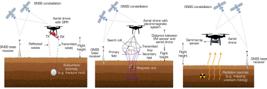
A conventional aerial drone-borne setup for geophysical surveys. GNSS = Global Navigation Satellite System; GR = groundreceiver; RX = receiver; TX = transmitter.
Drone in disaster management
Drones can offer a bird’s-eye perspective of events for on-scene investigation and reconnaissance. As a result, they can play a crucial role in safety, surveillance, and search and rescue operations (Anand et al. 2023; Daud et al. 2022; Ishiwatari 2024; Velev et al. 2019). Initially, several tools were available for these types of rescues. The primary flaw of these systems was their inadequate coverage, which prevented them from reaching and analyzing numerous areas effectively. It was suggested that UAVs incorporate detection procedures to maximize the information and save individuals or vehicles in danger. For instance, thermal properties can be used to detect people. Infrared cameras or thermal-based camera technology and algorithms are used for detection in this endeavor.
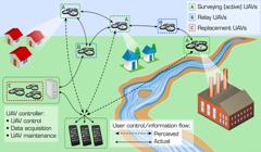
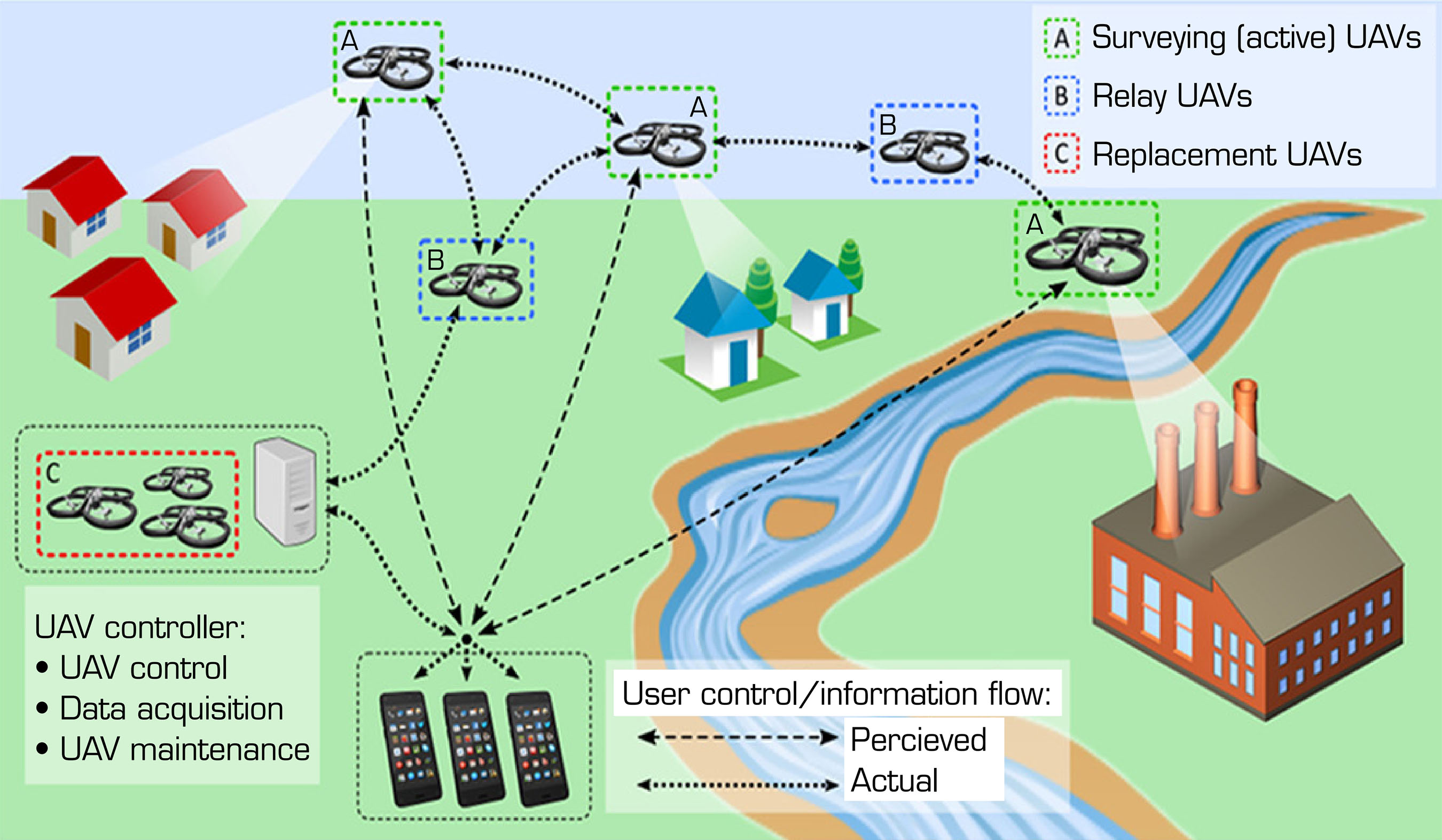
Integrating the required GIS and sensing sensors for search and rescue operations is the primary focus of the approach and method. Algorithms for search and detection were employed to obtain favorable outcomes. Real-time victim detection using global positional coordinates is possible with the established processes. Following the flight, the rescue crew judges their response based on a map of the explored zone. The drone can fly over the designated region to begin the process. Drones will be used for search and rescue during earthquakes, floods, landslides, storms, hurricanes, and other natural disasters. UAVs can safely and quickly transmit sensed data from remote locations. Data from the craft can help the crew understand the situation and identify individuals in danger who need support and assistance during natural disasters. Drones are a step ahead since they can deliver essential supplies to injured people, including water. Drones can be used to assist firefighters in combating wildfires. The utilization area determines the extent of the fire, its rate of spread, the health of the surrounding trees, temperature, air quality, and any risks to the rescuers. The UAV-assisted disaster management system is shown in Fig. 12.
Surveillance and monitoring
To detect humans in a specific location, the drone should be equipped with sensors such as cameras with both infrared and thermal capabilities, as well as an inertial navigation system (Fig. 13). After processing the detected data, the control unit assists field workers in emergencies. The field manager takes prompt action. Due to their low cost and speed, flexibility, autonomous flight capability, and ability to provide a bird’s-eye view, drones have been utilized extensively in recent years for crowd analysis and management at large meetings (Butcher et al. 2021). To assess the safety of the situation, the sensed photos are processed. Drone crowd surveillance would be an excellent way to monitor the number of people in the crowd, their behavior, and whether anyone is missing. It has been determined that the picture segmentation technique identifies and distinguishes the individual or target from the ambient environment. The result will be more accurate than the traditional approach of using a surveillance camera to monitor the crowd.
Detection of cracks in structures using drones
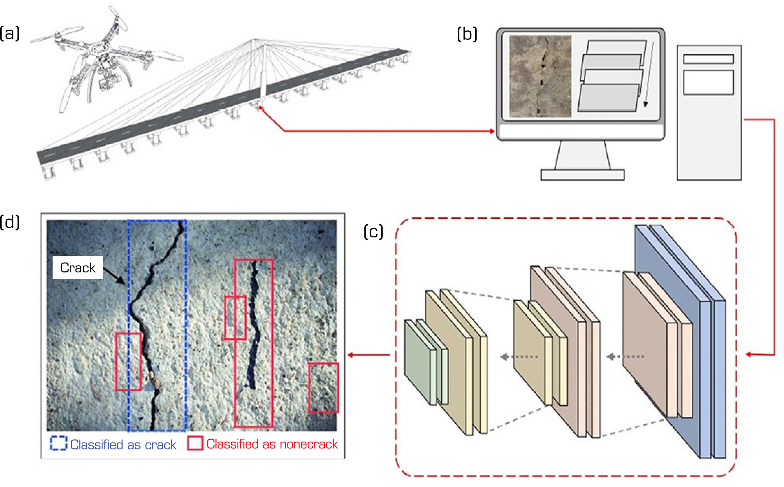
The concept of using a drone equipped with a camera for damage detection of structures can be seen in Fig. 14. After being taken by the camera, the pictures are sent for image processing in software, which improves contrast, lowers noise, and corrects distortion (Ding et al. 2023; Meng et al. 2023; Munawar et al. 2021; Zhu and Tang 2023). Cracks in the processed pictures can then be automatically detected and located using various image analysis methods. These algorithms identify regions that may indicate the presence of a crack using techniques such as pattern recognition, edge detection, or texture recognition. Identified cracks are categorized according to the following characteristics: severity, direction, width, and length. It is essential to consider that various factors, including surface roughness, illumination, image quality, and the expertise of the image analysts, influence the accuracy with which high-resolution cameras detect cracks (Ngo et al. 2023). Appropriate picture acquisition, processing, and analysis standards and methods should be put in place to ensure accurate and reliable results in crack detection. In addition, the most innovative technologies of the modern era, ML and AI, can be used to improve the ability to detect cracks, as this process will become more effective and efficient as, by teaching algorithms to recognize and categorize cracks with more accuracy, they will be better equipped to detect them and place them into their category, which will result in an increase in the effectiveness and efficiency of the process once again.
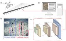
General concept of crack damage detection using a drone. (a) Image capture; (b) Image processing; (c) Crack classification; (d) Crack detection algorithm
Economic viability and cost-benefit analysis of drones in construction
The potential viability of adopting drones in the construction industry has gained more and more ground as the technology becomes viable by showing high returns on investment (ROI) in terms of productivity, safety, and accuracy of the data. Even though the initial investment required, including the drone equipment, state-of-the-art sensors like LiDAR or thermal image units, powerful data analysis software, training of operators, and compliance with aviation regulations, can seem substantial, the immediate benefits are soon offset by the operational efficiencies and savings. Among the most significant economic benefits of drone use is in surveying and mapping operations. Drones can now be used to complete traditional land surveys, which in most cases might take several days to complete or even weeks of manual labor by the ground crews. This time saving is directly proportional to decreased labor expenses and a shorter time to complete projects.
Also, drones generate high-resolution images, orthomosaic maps, and accurate 3D terrain images that are better when compared to traditional methods of measurement. This accuracy will translate into better planning of the sites, better resource management, lower wastage of materials, and a significant decrease in rework due to human mistakes or faulty measurements. Safety-wise, drone-based inspections offer a high economic advantage since workers will not be required to reach dangerous or high-altitude sites, e.g., rooftops, bridge decks, or high buildings. This not only reduces the risk of accidents and related compensation expenses, but also, in the long run, insurance premiums can be reduced. In addition, regular drone surveys facilitate constant progress tracking and monitoring of assets, whereby project managers have real-time grounds for detecting deviations at an early stage. Such problems are much cheaper to solve at an early stage in the construction process than at a later stage. Although this has some practical issues like the weather restrictions and the battery duration, as well as the availability of skilled personnel, the evidence on the economic front is overwhelmingly in favor of the use of drones. Research and commercial reports have demonstrated up to 60% of time saved when inspecting and reporting incidents, where companies achieved complete ROI in the first year of application. Altogether, these aspects make drones an affordable, disruptive technology that can not only improve the performance of the project but also bring economic sustainability to the construction industry in the long run.
Summary of the research
Based on the review, the following points are summarized:
-
Drones have entirely transformed the construction sector with precise data about surveying, mapping, inspecting, and monitoring safety. They have made it more productive, minimized human effort in dangerous locations, and made it more accurate in making decisions during project management by their potential to create real-time spatial information.
-
The integration of UAVs with high-resolution sensors that include LiDAR, RGB, and infrared cameras has made it possible to scan the specifics of 3D modeling, defects, and tracking progress. Combined with AI, ML, and BIM, drones can automate data analysis and allow predictive maintenance and resource optimization.
-
The benefits of drones, even though they may require some initial capital investment, have significant long-term economic paybacks as they bring down labor costs, minimize rework, and increase site safety. Their use helps to create sustainable building methods with the efficient use of materials by cutting the timeframes and reducing the risks that the workers are exposed to.
-
The review notes that although there are regulatory initiatives set by national aviation authorities like the FAA, EASA, DGCA, and ICAO, there are still considerable gaps within countries. The absence of standard global policies continues to suppress the cross-border activities of UAVs and scalability in the international construction projects.
-
The future should involve creating autonomous UAV swarm functions, AI-based data analysis, and the existence of BIM that can be used in real-time to provide project analytics. The integration of drone technologies could be a key to great photo-construction development, but the creation of international standards, data privacy, and cybersecurity will be essential to maximize the opportunities.
Future research directions for drones in construction
It is to standardize the use of drones in construction works internationally and compare regulations across various countries to find the best practices.
The study shall be carried out on cross-border compliance and drone certification options, research to see the possibilities of advanced collision-avoidance systems and drone failsafe.
It is necessary to adopt design methods on how to safely introduce drones to normal construction activities and set standards on how to evaluate and apply risks that are unique to the construction scenario.
Investing in drones with increased payload capacities to deliver material on-site and developing drones that can analyze data in real-time and have AI-powered monitoring services.
It is required to check how to study and how to connect the data gathered by the drones and BIM.
Test how drones can be used to minimize the carbon footprint of construction activity and use drones to monitor environmental compliance and minimize site impact.
To develop structures of cooperation between interested parties that embrace drone technology and evaluate the socio-economic implications of drone technology on construction labor and productivity.
ACKNOWLEDGEMENTS
Not applicable.
-
Peer Review History:
Single Blind Peer Review.
-
FUNDING
Not applicable.
DATA AVAILABILITY STATEMENT
All dataset were generated or analyzed in the current study.
REFERENCES
-
Aiyetan AO, Das DK (2023) Use of drones for construction in developing countries: barriers and strategic interventions. Int J Constr Manag 23(16):2888-2897. https://doi.org/10.1080/15623599.2022.2108026
» https://doi.org/10.1080/15623599.2022.2108026 -
Ajayi OG, Palmer M, Salubi AA (2018) Modelling farmland topography for suitable site selection of dam construction using drone (UAV) photogrammetry. Remote Sens Appl Soc Environ 11:220-230. https://doi.org/10.1016/j.rsase.2018.07.007
» https://doi.org/10.1016/j.rsase.2018.07.007 -
Alarcón VV, García M, Alarcón F, Viguria A, Martínez A, Janisch D, Ollero A (2020) Procedures for the integration of drones into the airspace based on U-Space services. Aerospace 7(9):128. https://doi.org/10.3390/aerospace7090128
» https://doi.org/10.3390/aerospace7090128 -
Ali BS (2019) Traffic management for drones flying in the city. Int J Crit Infrastruct Prot 26:100310. https://doi.org/10.1016/j.ijcip.2019.100310
» https://doi.org/10.1016/j.ijcip.2019.100310 - Anand J, Aasish C, Narayanan SS, Ahmed RA (2023) Drones for disaster response and management. Boca Raton: CRC Press. Internet of drones; p. 177-200
- Anwar N, Izhar MA, Najam FA (2018) Construction monitoring and reporting using drones and drones (UAVs). Paper presented 2018 The Tenth International Conference on Construction in the 21st Century. CITC Global; Colombo: Sri Lanka.
-
Ashraf S, Aggarwal P, Damacharla P, Wang H, Javaid AY, Devabhaktuni V (2018) A low-cost solution for drone navigation in a global positioning system-denied environment. Int J Distrib Sens Netw 14(6):155014771878175. https://doi.org/10.1177/1550147718781750
» https://doi.org/10.1177/1550147718781750 -
Biggs TW, Thengabail PS, Gumma MK, Scott CA, Parthasaradhi GR, Turral HN (2016) Irrigated area mapping in heterogeneous landscapes with MODIS time series, ground truth and census data, Krishna Basin, India. Int J Remote Sens 27(19):4245-4266. https://doi.org/10.1080/01431160600851801
» https://doi.org/10.1080/01431160600851801 -
Butcher PA, Colefax AP, Gorkin RA III, Kajiura SM, López NA, Mourier J, Purcell CR, Skomal GB, Tucker JP, Walsh AJ (2021) The drone revolution of shark science: a review. Drones 5(8). https://doi.org/10.3390/drones5010008
» https://doi.org/10.3390/drones5010008 -
Cardellicchio A, Ruggieri S, Nettis A, Renò V, Uva G (2023) Physical interpretation of machine learning-based recognition of defects for the risk management of existing bridge heritage. Eng Fail Anal 149:107237. https://doi.org/10.1016/j.engfailanal.2023.107237
» https://doi.org/10.1016/j.engfailanal.2023.107237 -
Chamola V, Kotesh P, Agarwal A, Gupta N, Guizani M (2020) A comprehensive review of drone attacks and neutralization techniques. Ad Hoc Netw 102324. https://doi.org/10.1016/j.adhoc.2020.102324
» https://doi.org/10.1016/j.adhoc.2020.102324 - Charavgis F (2016) Monitoring and assessing concrete bridges with intelligent techniques (doctoral dissertation). Delft: Delft University of Technology.
-
Chesley JTT, Leier ALL, White S, Torres R (2017) Using unmanned aerial vehicles and structure-from-motion photogrammetry to characterize sedimentary outcrops: an example from the Morrison Formation, Utah, USA. Sediment Geol 354:1-8. http://doi.org/10.1016/j.sedgeo.2017.03.013
» https://doi.org/10.1016/j.sedgeo.2017.03.013 -
Choi HW, Kim HJ, Kim SK, Na WS (2023) An overview of drone applications in the construction industry. Drones 7(8):515. https://doi.org/10.3390/drones7080515
» https://doi.org/10.3390/drones7080515 -
Daud SMSM, Yusof MYP M, Heo CC, Khoo LS, Singh MKC, Mahmood MS, Nawawi H (2022) Applications of drone in disaster management: a scoping review. Sci Justice 62(1):30-42. https://doi.org/10.1016/j.scijus.2021.11.002
» https://doi.org/10.1016/j.scijus.2021.11.002 -
Dheeravath V, Thenkabail PS, Chandrakantha G, Noojipady P, Reddy GP, Biradar CM, Velpuri M (2010) Irrigated areas of India derived using MODIS 500 m time series for the years 2001-2003. ISPRS J Photogramm Remote Sens 65(1):42-59. https://doi.org/10.1016/j.isprsjprs.2009.08.004
» https://doi.org/10.1016/j.isprsjprs.2009.08.004 -
Ding W, Yang H, Yu K, Shu J (2023) Crack detection and quantification for concrete structures using UAV and transformer. Automat Constr 152:104929. https://doi.org/10.1016/j.autcon.2023.104929
» https://doi.org/10.1016/j.autcon.2023.104929 -
Erdelj M, Natalizio E (2016) UAV-assisted disaster management: applications and open issues. Paper presented 2016 International Conference on Computing, Networking and Communications. IEEE; Kauai, USA. https://doi.org/10.1109/ICCNC.2016.7440563
» https://doi.org/10.1109/ICCNC.2016.7440563 -
Feroz S, Abu Dabous S (2021) UAV-based remote sensing applications for bridge condition assessment. Remote Sens 13:1809. https://doi.org/10.3390/rs13091809
» https://doi.org/10.3390/rs13091809 -
Giordan D, Adams MS, Aicardi I, Alicandro M, Allasia P, Baldo M, De Berardinis P, Dominici D, Godone D, Hobbs P, et al. (2020) The use of unmanned aerial vehicles (UAVs) for engineering geology applications. Bull Int Assoc Eng Geol 79: 3437-3481. https://doi.org/10.1007/s10064-020-01766-2
» https://doi.org/10.1007/s10064-020-01766-2 -
Gohari A, Ahmad AB, Rahim RBA, Supa’at ASM, Abd Razak S, Gismalla MSM (2022) Involvement of surveillance drones in smart cities: a systematic review. IEEE Access 10:56611-56628. http://doi.org/10.1109/ACCESS.2022.3177904
» https://doi.org/10.1109/ACCESS.2022.3177904 -
Gonzalez-Aguilera D, Rodríguez-Gonzalvez P (2017) Drones – An open access journal. Drones 1(1):1. https://doi.org/10.3390/drones1010001
» https://doi.org/10.3390/drones1010001 -
Guerra E, Munguía R, Grau A (2018) UAV visual and laser sensors fusion for detection and positioning in industrial applications. Sensors 18(7):2071. https://doi.org/10.3390/s18072071
» https://doi.org/10.3390/s18072071 -
Gupta A, Afrin T, Scully E, Yodo N (2021) Advances of UAVs toward future transportation: The state-of-the-art, challenges, and opportunities. Future Transp 1:326-350. https://doi.org/10.3390/futuretransp1020019
» https://doi.org/10.3390/futuretransp1020019 -
Gupta H, Verma OP (2021) Monitoring and surveillance of urban road traffic using low-altitude drone images: a deep learning approach. Multimed Tools Appl 81(14):1983-19703. https://doi.org/10.1007/s11042-021-11146-x
» https://doi.org/10.1007/s11042-021-11146-x -
Gupta S, Nair S (2023) A review of the emerging role of UAVs in construction site safety monitoring. Mater Today Proc https://doi.org/10.1016/j.matpr.2023.03.135
» https://doi.org/10.1016/j.matpr.2023.03.135 -
Halder S, Afsari K (2023) Robots in inspection and monitoring of buildings and infrastructure: a systematic review. Appl Sci 13(4):2304. https://doi.org/10.3390/app13042304
» https://doi.org/10.3390/app13042304 -
Harvey MC, Rowland JV, Luketina KM (2016) Drone with thermal infrared camera provides high resolution georeferenced imagery of the Waikite geothermal area, New Zealand. J Volcanol Geotherm Res 325:61-69. https://doi.org/10.1016/j.jvolgeores.2016.06.014
» https://doi.org/10.1016/j.jvolgeores.2016.06.014 -
Hassanalian M, Abdelkefi A (2017) Classifications, applications, and design challenges of drones: a review. Prog Aerosp Sci 91:99-131. https://doi.org/10.1016/j.paerosci.2017.04.003
» https://doi.org/10.1016/j.paerosci.2017.04.003 -
Huang X, Liu Y, Huang L, Stikbakke S, Onstein E (2023) BIM-supported drone path planning for building exterior surface inspection. Comput Ind 153:104019. https://doi.org/10.1016/j.compind.2023.104019
» https://doi.org/10.1016/j.compind.2023.104019 -
Husman MA, Albattah W, Abidin ZZ, Mustafah YM, Kadir K, Habib S, Islam M, Khan S (2021) Drones for crowd monitoring and analysis. Electronics 10:2974. https://doi.org/10.3390/electronics10232974
» https://doi.org/10.3390/electronics10232974 -
Ishiwatari M (2024) Leveraging drones for effective disaster management: a comprehensive analysis of the 2024 Noto Peninsula earthquake case in Japan. Prog Disaster Sci 100348. https://doi.org/10.1016/j.pdisas.2024.100348
» https://doi.org/10.1016/j.pdisas.2024.100348 -
Joshi PM (2015) Wing analysis of a flapping wing drone using CFD. Int J Adv Eng Res Sci 2(5):216-221. https://doi.org/10.21090/ijaerd.020530
» https://doi.org/10.21090/ijaerd.020530 -
Kangunde V, Jamisola RS, Theophilus EK (2021) A review on drones controlled in real-time. Int J Dynam Control 9:1832-1846. https://doi.org/10.1007/s40435-020-00737-5
» https://doi.org/10.1007/s40435-020-00737-5 -
Kardasz P, Doskocz J (2016) Drones possibilities of their using. J Civ Environ Eng 6(3):1-7. https://doi.org/10.4172/2165-784X.1000233
» https://doi.org/10.4172/2165-784X.1000233 -
Khan NA, Jhanjhi NZ, Brohi SN, Usmani RSA, Nayyar A (2020) Smart traffic monitoring system using unmanned aerial vehicles (UAVs). Comput Commun 157:434-443. https://doi.org/10.1016/j.comcom.2020.04.049
» https://doi.org/10.1016/j.comcom.2020.04.049 -
Kim P, Park J, Cho Y (2019) As-is geometric data collection and 3D visualization through the collaboration between UAV and UGV. Paper presented 2019 36th International Symposium on Automation and Robotics in Construction. IAARC; Banff, Canada. https://doi.org/10.22260/ISARC2019/0073
» https://doi.org/10.22260/ISARC2019/0073 -
Kim SR, Lee WK, Kwak DA, Biging G, Gong P, Lee JH, Cho HK (2011) Forest cover classification by optimal segmentation of high-resolution satellite imagery. Sensors 11(2):1943-1958. https://doi.org/10.3390/s110201943
» https://doi.org/10.3390/s110201943 -
Lee J, Jo H, Oh J (2023) Application of drone LiDAR survey for evaluation of a long-term consolidation settlement of large land reclamation. Appl Sci 13(14):8277. https://doi.org/10.3390/app13148277
» https://doi.org/10.3390/app13148277 -
Li J, Jiang S, Song L, Peng P, Mu F, Li H, Xu T (2023) Automated optical inspection of FAST’s reflector surface using drones and computer vision. Light Adv Manuf 4(1):3-13. https://doi.org/10.37188/lam.2023.001
» https://doi.org/10.37188/lam.2023.001 -
Li R, Yu J, Li F, Yang R, Wang Y, Peng Z (2023) Automatic bridge crack detection using drone and Faster R-CNN. Constr Build Mater 362:129659. http://doi.org/10.1016/j.conbuildmat.2022.129659
» https://doi.org/10.1016/j.conbuildmat.2022.129659 -
Liu Z, He Y, Yang L, Han J (2017) Control techniques of tilt rotor drone systems: a review. Chin J Aeronaut 30(1):135-148. https://doi.org/10.1016/j.cja.2016.11.001
» https://doi.org/10.1016/j.cja.2016.11.001 -
Lu X, Zhou J, Yang R, Yan Z, Lin Y, Jiao J, Liu F (2023) Automated rice phenology stage mapping using UAV images and deep learning. Drones 7(2):83. https://doi.org/10.3390/drones7020083
» https://doi.org/10.3390/drones7020083 -
Luo K, Kong X, Zhang J, Hu J, Li J, Tang H (2023) Computer vision-based bridge inspection and monitoring: a review. Sensors 23(18):7863. https://doi.org/10.3390/s23187863
» https://doi.org/10.3390/s23187863 -
Lyu Y, Cao M, Yuan S, Xie L (2023) Vision-based autonomous UAV estimation and following for building inspection. IEEE Trans Syst Man Cybern Syst 53(12):7475-7488. https://doi.org/10.48550/arXiv.2102.01423
» https://doi.org/10.48550/arXiv.2102.01423 -
Majumdar A, Tavawalla H (2021) India: Drone Law 2021 – New regime, old problems. Nat Law Rev XI(263). https://natlawreview.com/article/india-drone-law-2021-new-regime-old-problems
» https://natlawreview.com/article/india-drone-law-2021-new-regime-old-problems -
Martinez JG, Gheisari M, Alarcón LF (2020) UAV integration in current construction safety planning and monitoring process: case study of a high-rise building construction project in Chile. J Manag Eng 36:05020005. http://doi.org/10.1061/(ASCE)ME.1943-5479.0000761
» https://doi.org/10.1061/(ASCE)ME.1943-5479.0000761 -
Meng S, Gao Z, Zhou Y, He B, Djerrad A (2023) Real-time automatic crack detection method based on drone. Comput Aided Civ Infrastruct Eng 38(7):849-872. http://doi.org/10.1111/mice.12918
» https://doi.org/10.1111/mice.12918 -
Muhmad Kamarulzaman AM, Wan Mohd Jaafar WS, Mohd Said MN, Saad SNM, Mohan M (2023) UAV implementations in urban planning and related sectors of rapidly developing nations: a review and future perspectives for Malaysia. Remote Sens 15(11):2845. https://doi.org/10.3390/rs15112845
» https://doi.org/10.3390/rs15112845 -
Munawar HS, Ullah F, Heravi A, Thaheem MJ, Maqsoom A (2021) Inspecting buildings using drones and computer vision: a machine learning approach to detect cracks and damages. Drones 6(1):5. https://doi.org/10.3390/drones6010005
» https://doi.org/10.3390/drones6010005 -
Ngo BT, Luong CX, Ngo L, Luong HM (2023) Development of a solution for collecting crack images on concrete surfaces to assess the structural health of bridges using drone. J Inf Telecommun 7(3):304-316. http://doi.org/10.1080/24751839.2023.2185448
» https://doi.org/10.1080/24751839.2023.2185448 -
Nwaogu JM, Yang Y, Chan AP, Chi HL (2023) Application of drones in the architecture, engineering, and construction (AEC) industry. Automat Constr 150:104827. http://doi.org/10.1016/j.autcon.2023.104827
» https://doi.org/10.1016/j.autcon.2023.104827 -
Onososen AO, Musonda I, Onatayo D, Tjebane MM, Saka AB, Fagbenro RK (2023) Impediments to construction site digitalization using drones (UAVs). Drones 7(1):45. https://doi.org/10.3390/drones7010045
» https://doi.org/10.3390/drones7010045 -
Papageorgiou A, Tarkian M, Amadori K, Ölvander J (2018) Multidisciplinary design optimization of aerial vehicles: A review of recent advancements. Int J Aerosp Eng 2018:1-22. https://doi.org/10.1155/2018/4258020
» https://doi.org/10.1155/2018/4258020 -
Patrick OO, Nnadi EO, Ajaelu HC (2020) Effective use of quadcopter drones for safety and security monitoring in building construction sites: case study Enugu Metropolis Nigeria. J Eng Technol Res 12(1):37-46. https://doi.org/10.5897/JETR2020.0695
» https://doi.org/10.5897/JETR2020.0695 -
Perikleous D, Margariti K, Velanas P, Blazquez CS, Gonzalez-Aguilera D (2025) Aerial drones for geophysical prospection in mining: a review. Drones 9(5):383. https://doi.org/10.3390/drones9050383
» https://doi.org/10.3390/drones9050383 -
Prabu B, Malathy R, Taj MG, Madhan N (2022) Drone networks and monitoring systems in smart cities. Boca Raton; CRC Press.AI-centric smart city ecosystems. p. 123-148. https://doi.org/10.1201/9781003252542-8
» https://doi.org/10.1201/9781003252542-8 -
Radoglou-Grammatikis P, Sarigiannidis P, Lagkas T, Moscholios I (2020) A compilation of UAV applications for precision agriculture. Comput Netw 107148. https://doi.org/10.1016/j.comnet.2020.107148
» https://doi.org/10.1016/j.comnet.2020.107148 -
Regona M, Yigitcanlar T, Hon C, Teo M (2024) Artificial intelligence and sustainable development goals: systematic literature review of the construction industry. Sustain Cities Soc 105499. https://doi.org/10.1016/j.scs.2024.105499
» https://doi.org/10.1016/j.scs.2024.105499 -
Rojas Viloria D, Solano-Charris EL, Muñoz-Villamizar A, Montoya-Torres JR (2021) Unmanned aerial vehicles/drones in vehicle routing problems: a literature review. Int Trans Oper Res 28:1626-1657. https://doi.org/10.1111/itor.12783
» https://doi.org/10.1111/itor.12783 -
Said KO, Onifade M, Githiria JM, Abdulsalam J, Bodunrin MO, Genc B, Akande JM (2021) On the application of drones: a progress report in mining operations. Int J Min Reclam Environ 35(4):235-267. https://doi.org/10.1080/17480930.2020.1804653
» https://doi.org/10.1080/17480930.2020.1804653 -
Sandino J, Vanegas F, Maire FD, Caccetta P, Sanderson C, Gonzalez F (2020) UAV framework for autonomous onboard navigation and people/object detection in cluttered indoor environments. Remote Sens 12(20):3386. https://doi.org/10.3390/rs12203386
» https://doi.org/10.3390/rs12203386 -
Schauwecker K, Ke NR, Scherer SA, Zell A (2012) Markerless visual control of a quad-rotor micro aerial vehicle by means of onboard stereo processing. Berlin Heidelberg: Springer. Autonomous mobile systems http://doi.org/10.1007/978-3-642-32217-4_2
» https://doi.org/10.1007/978-3-642-32217-4_2 -
Sestras P, Badea G, Badea AC, Salagean T, Roșca S, Kader S, Remondino F (2025) Land surveying with UAV photogrammetry and LiDAR for optimal building planning. Automat Constr 173:106092. http://doi.org/10.1016/j.autcon.2025.106092
» https://doi.org/10.1016/j.autcon.2025.106092 -
Shahmoradi J, Talebi E, Roghanchi P, Hassanalian M (2020) A comprehensive review of applications of drone technology in the mining industry. Drones 4(3):34. https://doi.org/10.3390/drones4030034
» https://doi.org/10.3390/drones4030034 -
Staffa Junior LDB, Bastos Costa D, Torres Nogueira JL, Silva AS (2025) Web platform for building roof maintenance inspection using UAS and artificial intelligence. Int J Build Pathol Adapt 43(1):4-28. http://doi.org/10.1108/IJBPA-12-2022-0186
» https://doi.org/10.1108/IJBPA-12-2022-0186 -
Szóstak M, Nowobilski T, Mahamadu AM, Pérez DC (2023) Unmanned aerial vehicles in the construction industry – towards a protocol for safe preparation and flight of drones. Int J Intell Unmanned Syst 11(2):296-316. https://doi.org/10.1108/IJIUS-05-2022-0063
» https://doi.org/10.1108/IJIUS-05-2022-0063 -
Tatum MC, Liu J (2017) Unmanned aircraft system applications in construction. Procedia Eng 196:167-175. https://doi.org/10.1016/j.proeng.2017.07.187
» https://doi.org/10.1016/j.proeng.2017.07.187 -
Umar T (2021) Applications of drones for safety inspection in the Gulf Cooperation Council construction. Eng Constr Archit Manag 28(9):2337-2360. http://doi.org/10.1108/ECAM-05-2020-0369
» https://doi.org/10.1108/ECAM-05-2020-0369 -
Valavanis KP, Vachtsevanos GJ (2015) Handbook of unmanned aerial vehicles Berlin Heidelberg: Springer. https://doi.org/10.1007/978-90-481-9707-1
» https://doi.org/10.1007/978-90-481-9707-1 -
Van Wyk L, Kajimo-Shakantu K, Opawole A (2024) Adoption of innovative technologies in the South African construction industry. Int J Build Pathol Adapt 42(3):410-429. https://doi.org/10.1108/IJBPA-06-2021-0090
» https://doi.org/10.1108/IJBPA-06-2021-0090 -
Velev D, Zlateva P, Steshina L, Petukhov I (2019) Challenges of using drones and virtual/augmented reality for disaster risk management. Int Arch Photogramm Remote Sens Spatial Inf Sci 42:437-440. http://doi.org/10.5194/isprs-archives-XLII-3-W8-437-2019
» https://doi.org/10.5194/isprs-archives-XLII-3-W8-437-2019 -
Wang J, Ueda T (2023) A review study on unmanned aerial vehicle and mobile robot technologies on damage inspection of reinforced concrete structures. Struct Concr 24(1):536-562. http://doi.org/10.1002/suco.202200846
» https://doi.org/10.1002/suco.202200846 -
Yamane T, Chun PJ, Dang J, Honda R (2023) Recording of bridge damage areas by 3D integration of multiple images and reduction of the variability in detected results. Comput Aided Civ Infrastruct Eng 38(17):2391-2407. http://doi.org/10.1111/mice.12971
» https://doi.org/10.1111/mice.12971 -
Yang X, del Rey Castillo E, Zou Y, Wotherspoon L (2024) UAV-deployed deep learning network for real-time multi-class damage detection using model quantization techniques. Autom Constr 159:105254. https://doi.org/10.1016/j.autcon.2023.105254
» https://doi.org/10.1016/j.autcon.2023.105254 -
Zhang J, Virk S, Porter W, Kenworthy K, Sullivan D, Schwartz B (2019) Applications of unmanned aerial vehicle-based imagery in turfgrass field trials. Front Plant Sci 10. https://doi.org/10.3389/fpls.2019.00279
» https://doi.org/10.3389/fpls.2019.00279 -
Zhu Y, Tang H (2023) Automatic damage detection and diagnosis for hydraulic structures using drones and artificial intelligence techniques. Remote Sens 15(3):615. https://doi.org/10.3390/rs15030615
» https://doi.org/10.3390/rs15030615
Edited by
-
Section editor:
Paulo Renato Silva https://orcid.org/0000-0003-0106-2230

 Source: Retrieved from
  Source: Retrieved from
  Source: Retrieved from
  Source: Adapted from
  Source: Retrieved from
  Source: Retrieved from
  Source: Retrieved from
  Source: Retrieved from
  Source: Retrieved from
  Source: Retrieved from
  Source: Retrieved from
  Source: Retrieved from
  Source: Retrieved from
  Source: Retrieved from