 KARST GEOHERITAGE AND THE GEOTERRITORY APPROACH IN LANDSCAPES OF HIGH GEOMORPHOLOGICAL RELEVANCE
Abstract
This paper evaluates the geoterritorialization process of the Circuito das Grutas (Minas Gerais, Brazil), focusing on the patrimonialization of karst and speleological geodiversity. A qualitative and exploratory approach is adopted, combining documentary and institutional review, analysis of media materials, and field visits supported by systematic photographic records at key sites across the territory. The analysis operationalises and adapts the framework proposed by Hobléa et al. (2021) through nine criteria-documentation, inventorying, protection, management, geotouristification, geoeducation, social appropriation, specification, and territorial distinction-allowing the classification of consolidation stages (incipient, intermediate, and consolidated). Results point to an overall incipient trajectory, with more visible progress in documentation, legal protection, and localised tourism infrastructure, but persistent gaps in systematic inventorying, geoeducation, territorial specification, and integrated management. The paper concludes that consolidating the geoterritory requires stronger institutional articulation, monitoring, and continuity of public policies to reinforce social appropriation and long-term governance of karst geoheritage.
Keywords:
Geotourism; Karst; Circuito das Grutas; GeoRegions.
Resumo
Este artigo avalia o processo de geoterritorialização do Circuito das Grutas (MG), com foco na patrimonialização da geodiversidade em contexto cárstico e espeleológico. Adota-se uma abordagem qualitativa e exploratória, baseada em levantamento documental e institucional, na análise de materiais midiáticos e em visitas de campo, com registros fotográficos, em pontos-chave do território. A análise operacionaliza e adapta a matriz de Hobléa et al. (2021) por meio de nove critérios: documentação, inventariação, proteção, gestão, geoturistificação, geoeducação, apropriação social, especificação e distinção territorial, permitindo classificar o estágio de consolidação das ações (incipiente, intermediário e consolidado). Os resultados indicam um quadro geralmente incipiente, com avanços mais visíveis na documentação, na proteção e na infraestrutura turística localizada, mas com lacunas persistentes na inventariação sistemática, na geoeducação, na especificação territorial e na gestão integrada. Conclui-se que a consolidação do geoterritório depende de maior articulação institucional, de monitoramento e de continuidade das políticas, de modo a fortalecer a apropriação social e a governança do geopatrimônio cárstico.
Palavras-chave:
Geoturismo; Carste; Circuito das Grutas; GeoRegião.
Résumé
Cet article évalue le processus de géoterritorialisation du Circuito das Grutas (Minas Gerais, Brésil), en mettant l’accent sur la patrimonialisation de la géodiversité karstique et spéléologique. L’étude adopte une démarche qualitative et exploratoire, fondée sur l’analyse documentaire et institutionnelle, l’examen de matériaux médiatiques et des visites de terrain, appuyées par des relevés photographiques systématiques à des points clés du territoire. L’analyse opérationnalise et adapte la matrice de Hobléa et al. (2021) à partir de neuf critères-documentation, inventaire, protection, gestion, géotouristification, géoéducation, appropriation sociale, spécification et distinction territoriale-afin de qualifier les stades de consolidation (incipient, intermédiaire et consolidé). Les résultats suggèrent une trajectoire globalement incipiente, avec des avancées plus perceptibles en matière de documentation, de protection juridique et d’infrastructures touristiques localisées, mais aussi des lacunes en matière d’inventaire systématique, de géoéducation, de spécification territoriale et de gestion intégrée. La consolidation du géoterritoire dépend d’une meilleure articulation institutionnelle, du suivi et de la continuité des politiques publiques afin de renforcer l’appropriation sociale et la gouvernance durable du géopatrimoine karstique.
Mots-clés:
Géotourisme; Karst; Circuit des Grottes; GéoRégion.
INTRODUCTION
Geodiversity, a concept consolidated over the last three decades, corresponds to the variety of the Earth’s abiotic elements and processes, including minerals, rocks, fossils, landforms, soils, water, and their spatial interactions (GRAY, 2013, 2024). From it derives the concept of geoheritage, which encompasses components endowed with scientific, educational, aesthetic, or cultural value, and that are eligible for protection and social valorisation (RUCHKYS et al., 2018; GUIMARÃES et al., 2022; ARRUDA et al., 2024; CLAUDINO-SALES, 2024; SILVA et al., 2024). Geoconservation is the field devoted to the management of these assets, while geotourism (HOSE, 1995, 2000) serves as a form of public mediation, articulating science, territorial identity, and local development.
Discussions of geodiversity and related themes have expanded to include risk analyses, valuation of geosystem services, and integrated approaches to landscape, culture, and territorial planning (KUBALÍKOVÁ et al., 2025). It is essential to emphasise, however, that geodiversity and landscape are not synonymous. Geodiversity constitutes the abiotic and scientific basis of the territory. In contrast, the landscape, relational in nature, results from the interaction among abiotic, biotic, and cultural factors and is constantly constructed and re-signified through social practices and human perceptions (SANTOS, 2006; DANTAS et al., 2015). Thus, landscape incorporates geodiversity but transcends it by mobilising ecological, cultural, and symbolic dimensions.
Among the elements of geodiversity, geomorphological features have gained prominence, both for their aesthetic and symbolic value, reinforcing the importance of geomorphology in contemporary debates on conservation, territorial ordering, and territorial valorisation. The process of patrimonialization of geodiversity involves three main axes-selection, protection, and valorisation (LAPLANTE, 1992; DOUMIT, 2007; DUVAL, 2007; LANDEL and SENIL, 2009; HOBLÉA et al., 2021)-through which abiotic elements are reinterpreted as cultural, scientific, and identity assets. Reconfigured as territorial resources, these elements acquire a territorialising effect, influencing social practices, public policies, and symbolic bonds with the territory (REYNARD and BUSSARD, 2021).
In this context, understanding territory becomes central. More than a surface delimited on maps, territory is a space of social relations, marked by disputes, powers, and meanings built over time (SANTOS, 2006; SOUZA, 2009; BARBOSA, 2021). Thus, the geoterritory emerges as an analytical category that highlights the social, political, and economic activation of geoheritage. According to Hobléa et al. (2021), the geoterritory is not merely a physical space but a relational configuration articulated through educational, cultural, and governance practices. The process of geoterritorialization, in turn, entails converting elements of geodiversity into strategic resources that promote social cohesion, territorial identity, and sustainable development. Far from being linear, this process is dynamic and iterative, resulting from multiple trajectories of patrimonialization (LANDEL and SENIL, 2009; REYNARD and BUSSARD, 2021).
Consolidated instruments, such as UNESCO Global Geoparks, exemplify the materialisation of this approach by integrating conservation, tourism, education, and territorial governance. More recently, alternatives such as the GeoRegions model in Australia (OAM, 2023) have proposed progressive strategies of territorial valorisation, based on heritage audits, participatory planning, and interpretive geotrails, even without the formal status of a geopark.
In this scenario, karst areas play a prominent role. Originally defined by Cvijić (1893) and Martel (1921), they correspond to geomorphological systems derived from the dissolution of soluble rocks such as limestones, dolostones, and evaporites, characterised by distinctive surface (exokarst, such as dolines, uvalas, and poljes) and subterranean (endokarst, such as caves, galleries, and conduits) features (FORD and WILLIAMS, 2007; TRAVASSOS, 2019). Due to their hydrogeological complexity and heterogeneity of forms, karst has been widely recognised as a privileged territory for the creation of geoparks and for geoconservation and geotourism practices (RUBAN, 2018; RUCHKYS and AULER, 2025).
Despite the scientific and heritage relevance of Brazilian karst, the application of the geoterritory model remains incipient in the country, with no systematic studies using the analytical matrix of Hobléa et al. (2021) in karst regions. This gap constitutes the main challenge that this work seeks to address. Thus, the objective of this article is to evaluate the geoterritorialization process of the Circuito das Grutas de Minas Gerais, based on the nine criteria proposed by Hobléa et al. (2021): documentation, inventorying, protection, management, geotouristification, geoeducation, social appropriation, specification, and territorial distinction.
The research adopts a qualitative, exploratory approach, combining a documentary survey, analysis of institutional and media materials, and field visits to key sites in the region. It is acknowledged, however, that the analysis of symbolic appropriation and local dynamics was only tangentially addressed and warrants further investigation. By articulating the theoretical discussion of geodiversity patrimonialization with the empirical analysis of Minas Gerais karst, this work aims to advance methodological approaches to geoconservation and to provide insights for territorial valorisation strategies in Brazilian contexts.
MATERIALS AND METHODS
STUDY AREA
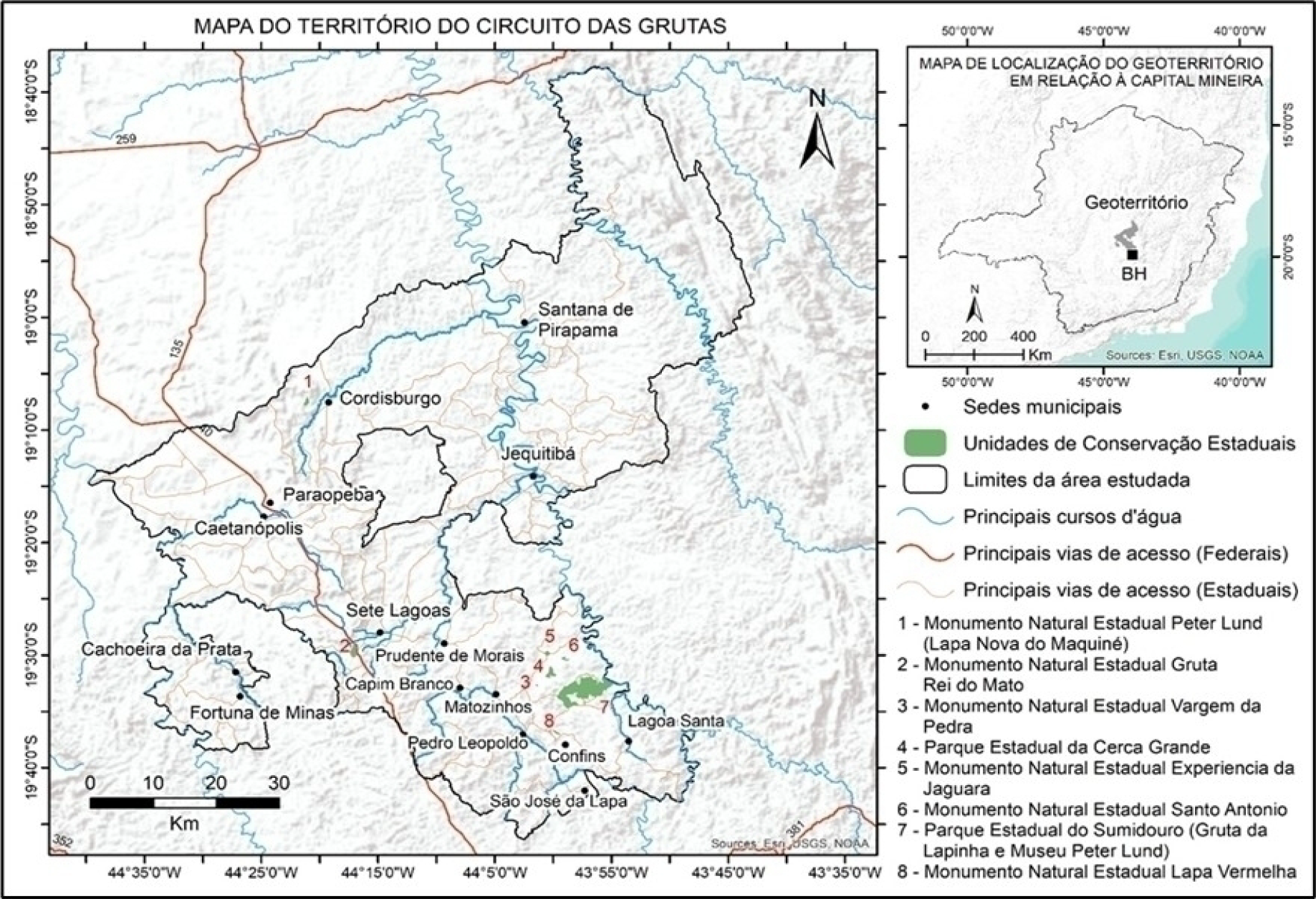
The Circuito das Grutas de Minas Gerais comprises 15 municipalities that share significant karst formations and a substantial geospeleological heritage. They are: Cachoeira da Prata, Caetanópolis, Capim Branco, Confins, Cordisburgo, Fortuna de Minas, Jequitibá, Lagoa Santa, Matozinhos, Paraopeba, Pedro Leopoldo, Prudente de Morais, Santana de Pirapama, São José da Lapa, and Sete Lagoas (Figure 1).
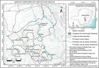
Location map of the municipalities and the main state-protected areas that make up the so-called Circuito das Grutas in Minas Gerais. The area analysed from the perspective of the geoterritory concept, as a space of geological, environmental, and touristic relevance. Due to the map scale, some protected areas are indicated by the corresponding number in the legend (Source: prepared by the authors, 2025).
According to the official website of the tourism governance body (CIRCUITO DAS GRUTAS, n.d.), the territory builds its identity based on elements of geodiversity, especially the Maquiné, Lapinha, and Rei do Mato caves. These formations constitute the so-called Rota das Grutas de Lund, conceived as a public policy for tourism regionalisation, which articulates municipalities and geocultural attractions around a common thematic axis (OLIVEIRA, 2018). The route, however, concentrates visibility on only a few geosites, reinforcing the selectivity of the heritage valorisation process.
THEORETICAL AND METHODOLOGICAL FRAMEWORK
This research adopts the concept of geoterritory, as proposed by Hobléa et al. (2021), understood as a territorial configuration structured around the social, cultural, political, and economic activation of geoheritage. The model begins with the premise that, when recognised, protected, and valued, elements of geodiversity become strategic territorial resources that promote social cohesion, identity, and sustainable development.
Within this theoretical framework, the present work stands among the first empirical applications of the Hobléa et al. (2021) model in the Brazilian context, particularly in karst areas, highlighting its capacity to adapt to distinct institutional and geographic realities. Rather than assuming a linear logic based on successive stages of selection, protection, and valorisation, the study proposes a processual, iterative, and contextualised reading of geoheritage territorialization in Brazil, recognising the plurality of patrimonialization pathways and the possibility that different combinations among analytical axes may produce distinct territorialising effects.
METHODOLOGICAL ADAPTATION IN RELATION TO HOBLÉA ET AL. (2021)
The method developed by Hobléa et al. (2021) was structured around three central blocks of patrimonialization-selection, protection, and valorisation-each supported by specific data sources and by field and desk procedures. Below, the model's original elements and the adaptations made in this study are presented.
I - Selection:
In the original model, the selection stage is primarily based on national, regional, and local inventories, as well as on the classification of geosites by relevance scale.
In this study, this stage was operationalised using SIGEP (Berbet-Born, 2002) as a reference inventory, complemented by legal heritage listing records, information on federal and state protected areas, and an analysis of available management plans.
II - Protection:
In Hobléa et al. (2021), the protection dimension is based on identifying existing legal mechanisms and analysing environmental conflicts at the local scale.
In this work, the adaptation consisted of a documentary analysis of the main official instruments for protecting natural and cultural heritage, including the survey of protected areas and legal provisions applicable to the study area, without the direct incorporation of local-level conflict analyses.
III - Territorial and symbolic valorisation:
In the original model, valorisation is analysed using prior research on geotourism and geoeducation, formal and informal interviews with managers and local actors, and visitation data for museums, interpretive centres, theme parks, and natural sites.
In the adaptation carried out here, this dimension was addressed through the analysis of institutional materials (park and Circuito das Grutas websites and promotional folders), local media content (newspapers and tourism portals), and non-participatory field photographic records. The interviews foreseen in the original model were replaced by indirect observation, due to the unavailability of systematised primary data from local communities.
IV - Methodological synthesis:
In summary, while Hobléa et al. (2021) could rely on consolidated inventories and on primary field data such as interviews and audience surveys, applying the model to the Circuito das Grutas required a more flexible methodological approach. This approach combined secondary data of scientific, legal, and institutional nature with complementary information sources, while preserving the analytical logic and the core objectives of the original model.
ANALYTICAL CRITERIA
The degree of geoterritoriality of a region can be assessed using the nine criteria developed by Hobléa et al. (2021), which are organised into three central processes of patrimonialization: selection, protection, and valorisation. These criteria were chosen for their capacity to operationalise, synthetically and comparably, the level of territorial activation of geoheritage across multiple scales (Table 1). The integrated application of these criteria enables the assessment of the degree of consolidation of the geoterritory, based on concrete evidence of technical, institutional, symbolic, and socioeconomic action.
Geoterritoriality criteria. Source: Adapted from Hobléa et al. (2021). Organised by the authors.
TECHNIQUES AND DATA SOURCES
With the Circuito das Grutas delimited as a case study, the methodology adopted a qualitative and exploratory approach, structured around four main strategies: (i) documentary survey, based on the analysis of non-official geoheritage inventories (such as SIGEP), legal records (heritage listings, protected areas), management plans, technical reports from public and private institutions, as well as dissertations, theses, and scientific articles; (ii) application of the analytical matrix using the nine geoterritoriality criteria proposed by Hobléa et al. (2021), considering secondary data to identify gaps, potentialities, and dynamics underway in the territory; (iii) analysis of institutional and media materials, carried out through the collection and systematization of information on official websites of protected areas and of the Circuito das Grutas, folders and institutional reports, as well as content from local newspapers and tourism portals; and (iv) exploratory field visits, which made it possible to document elements of geoheritage, evaluate available tourism infrastructure, and record educational, interpretive, or symbolic initiatives associated with the karst environment.
Field visits were exploratory and non-participant in nature, focusing on: (a) recording and describing geoheritage elements and key exokarst/endokarst features at the main points of the Circuit; (b) verifying visitation conditions and infrastructure (access, signage, visitor centres, guiding/route organisation, control and safety measures); and (c) identifying the presence/absence of interpretive mediation and geoeducation actions (panels, educational materials, interpretive routes, museums/centres). Records consisted of photographic documentation and field notes for each visited point, later used to qualify and indirectly validate evidence, mainly related to the criteria of geotourism, geoeducation, management, and territorial distinction. No formal interviews were conducted.
These different strategies mobilised diverse, complementary sources. Inventories and official records provided the primary documentary base, while technical reports, institutional materials, and academic production offered more in-depth secondary analyses. Media sources and field-collected photographic records helped broaden and validate the information obtained. This triangulation ensured greater consistency of the analysed data and enabled the identification of convergences and gaps in territorial patrimonialization processes (Table 2).
ASSESSMENT SCALE
While Hobléa et al. (2021) only suggest the possibility of grading geoterritoriality criteria, without proposing a measurement scale, the present study introduces an original methodological adaptation. To enable the empirical application of the matrix in contexts characterised by lower availability of systematised data, as is the case in Brazil, an ordinal three-level scale was defined, allowing the degree of achievement of each criterion to be classified clearly and comparably:
-
I - Incipient: when the criterion shows fragmented, poorly articulated, or weak evidence.
-
II - Intermediate: when there are partial initiatives or initiatives under consolidation, still limitedin scope and institutional articulation.
-
III - Consolidated: when the criterion shows broad coverage, recognised effectiveness, andintegration with public policies or institutional networks.
Adopting this scale represents a necessary simplification for the Brazilian context, marked by a scarcity of systematised primary data and institutional heterogeneity among municipalities. This option favours international comparability and ensures greater methodological transparency, while avoiding artificial gradations that could compromise the consistency of the analysis.
LIMITATIONS OF THE ANALYSIS
It is important to note that, in the present study, the social appropriation criterion could not be fully assessed due to the absence of interviews, participatory workshops, or perception surveys with local communities. Thus, the results presented focus on the other eight criteria, while preserving methodological consistency and acknowledging the limitations inherent to the indirect nature of the evidence employed. It should be noted that institutional and media sources were used to characterise public communication, offerings, and framings of the territory, and that these sources do not replace the direct assessment of local communities’ perceptions, values, and identity-based ties.
RESULTS
DOCUMENTATION
Scientific and technical production on the region’s geoheritage is significant, especially in municipalities within the APA Carste de Lagoa Santa. Classical studies (HERRMANN et al., 1998; BERBERT-BORN, 2002) document dozens of karst lakes, caves, and other karst landscape features of high geoscientific value.
However, this documentation remains partial, dispersed, and poorly suited to local management and territorial promotion processes. Thus, although there is a solid base of accumulated knowledge, the documentation criterion can be classified as intermediate, due to its limited institutional and social appropriation.
INVENTORYING
Although there are relevant inventories, such as Berbet-Born (2002), which recognise the Carste de Lagoa Santa as a region of high geoheritage value, these surveys have not yet been systematised under an integrated geotouristic or territorial perspective. Most geosites in the Circuito das Grutas remain without formal characterisation as geoheritage, which limits their inclusion in public policies specific to the theme and, consequently, restricts their use in territorial ordering and valorisation strategies.
More recently, Sena et al. (2022) conducted a detailed geotouristic assessment, but were restricted to the northern portion of the APA Carste de Lagoa Santa, specifically to the area recognised as a Ramsar site by UNESCO, highlighting the fragmentation of approaches and the need to expand the analytical scale. Given these limitations, the inventorying criterion is considered incipient, since the lack of systematisation and territorial coverage compromises progress in the geoheritage selection process.
PROTECTION
The region hosts a mosaic of protected areas and natural monuments, including Environmental Protection Areas (APAs), state parks, and listed sites, which provide some legal protection for the karst landscape and associated geosites. Among existing instruments, the following stand out: Área de Proteção Especial Aeroporto (Confins, Lagoa Santa, Pedro Leopoldo, and Matozinhos); Monumento Natural Experiência da Jaguara (Matozinhos); Monumento Natural Lapa Vermelha (Pedro Leopoldo); Monumento Natural de Santo Antônio (Matozinhos); Monumento Natural Vargem da Pedra (Matozinhos); Monumento Natural Várzea da Lapa (Lagoa Santa); Parque Estadual do Sumidouro (Lagoa Santa and Pedro Leopoldo); Parque Estadual Cerca Grande (Matozinhos); and Gruta do Baú, whose management plan is still under approval and under private management (BARBOSA, 2021).
Despite the diversity of legal figures, the absence of articulation and integration mechanisms among these instruments compromises the effectiveness of protection. The fragility of connections between geoconservation and geotourism policies limits the territorial reach of existing measures, which tend to be confined to isolated areas and fail to generate systemic impacts across the circuit as a whole. In this sense, the protection criterion can be classified as intermediate, as it has a broad normative basis but limited effectiveness and integration.
MANAGEMENT
The Regional Governance Instance (IGR Grutas) is officially responsible for articulating tourism policies within the territory. However, its performance indicates centralised decision-making, low representation of peripheral municipalities, and reduced civil society participation (TAVARES, 2024). In parallel, the management of natural and cultural heritage remains fragmented across agencies and institutional levels, with no specific strategies for geoheritage.
This situation results in punctual, uncoordinated actions that are incapable of consolidating effective, multisectoral territorial governance. Thus, the management criterion is considered incipient due to the lack of articulation among tourism, environment, culture, and local communities.
GEOTOURISTIFICATION
Geotouristification in the Circuito das Grutas is concentrated in a few tourism hubs, particularly the Lapinha, Maquiné, and Rei do Mato caves, which are the only geosites with consolidated infrastructure for reception, guided visitation, and interpretive mediation. These attractions are part of official tourism itineraries, with structures ranging from visitor centres and museums to signage, walkways, and support services (ARAÚJO, 2019; ALT et al., 2024). Another site under structuring is Gruta do Baú, privately managed and with an ongoing management plan, whose potential to expand geotouristic practices remains incipient. This pattern evidences a selective valorisation model, in which only established geosites receive investment and visibility, to the detriment of other spaces with equal or greater scientific and landscape relevance. The creation of the Rota das Grutas de Lund represented an advance by articulating science, culture, and tourism. Still, it also generated conflicts over the delimitation of protected areas and the imposition of use restrictions (OLIVEIRA, 2018). In this sense, the geotouristification criterion is classified as intermediate, marked by localised advances but with low territorial capillarity.
GEOEDUCATION
The integration of geoheritage into educational practices occurs in a punctual and poorly articulated way. Parque Estadual do Sumidouro, with Gruta da Lapinha and Museu Peter Lund, constitutes the most structured core of heritage and environmental education actions, integrating monitored visits, school activities, and science outreach projects. Other spaces, such as Parque Estadual de Cerca Grande, have educational potential but remain in an initial phase of structuring and still lack an approved management plan. Currently, use is restricted to research and occasional educational activities by appointment, indicating the absence of a consolidated public visitation and geotourism policy.
Despite the recurrent use of caves in school activities, there is no regional geoeducation policy, which limits continuity and integration among schools, communities, and protected areas. Thus, the geoeducation criterion is considered incipient, revealing one of the main gaps for consolidating the geoterritory.
SOCIAL APPROPRIATION
Social appropriation was not assessed because it requires specific qualitative methodologies, which constitutes a limitation of the study and a promising field for future research.
TERRITORIAL SPECIFICATION
The territorial specification of geoheritage in the Circuito das Grutas remains incipient and poorly operationalised. Although some geosites appear in municipal master plans or in environmental and tourism regulations, their effective integration into local and regional development strategies remains limited, discontinuous, and concentrated in specific cores.
This scenario contrasts with the region’s karst landscape's notable expressiveness, marked by limestone cliffs, dolines, uvalas, poljes, and blind valleys-elements of high aesthetic, identity, and interpretive value. However, these attributes have not yet been mobilised as active components of territorialization, remaining invisible in official strategies of ordering, tourism, or territorial development. Thus, the territorial specification criterion is considered incipient.
TERRITORIAL DISTINCTION
Regarding territorial designation, the Circuito das Grutas has limited and sectoral recognition, such as IPHAN's federal heritage listing of Cerca Grande. In addition, the APA Carste de Lagoa Santa was classified as a site of geological, geomorphological, and paleontological relevance by SIGEP (BERBET-BORN, 2002), reinforcing its scientific importance. In 2017, part of the APA was designated a Ramsar Site by UNESCO due to the presence of karst-associated wetland systems. However, these recognitions have not yet been appropriated as vectors of shared territorial identity nor articulated into broad strategies of geodiverse patrimonialization. This absence of distinction devices limits projection at national and international levels, weakening the symbolic and institutional effects of patrimonialization. The circuit's name references an element of geodiversity-the caves-but geoheritage, as a structuring resource, remains underexplored. Therefore, the territorial distinction criterion is assessed as intermediate.
DISCUSSION
Karst landscapes, characterised by geomorphological features such as caves, dolines, limestone cliffs, dry valleys, and underground rivers, constitute complex and expressive natural systems (FORD and WILLIAMS, 2007). The dynamics of these environments largely result from the dissolution of carbonate rocks by water action, which gives them distinctive hydrogeological and ecological characteristics. Like other expressions of geodiversity, these landscapes should not be understood solely as natural formations but also as potential territorial resources that can be socially activated through patrimonialization processes (HOBLÉA et al., 2021; REYNARD and BUSSARD, 2021).
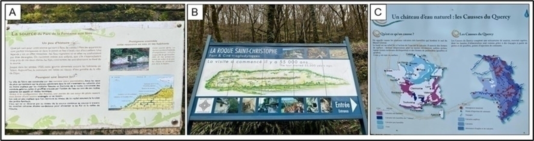
International examples, such as those in France, reveal distinct stages of geoterritorialization of karst landscapes, which articulate environmental protection, landscape interpretation, and sustainable territorial development. In the Fontaine aux Fées Park in Talant (Dijon, Burgundy), thematic trails and viewpoints offer an accessible geological and geomorphological interpretation of the regional limestone massif. This landscape formed about 160 million years ago, when the region was submerged by a shallow sea whose sediments gave rise to the current carbonate rocks. Today, nearly half of Burgundy rests on this substrate, conferring strong geodiverse expressiveness to the region. Interpretive resources in the park facilitate understanding of local karst and highlight ongoing patrimonialization efforts (Figure 2a).
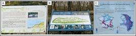
(a) Sign about the spring at Fontaine aux Fées Park, a former natural spring used by the population of Talant until the 1920s. According to the legend, it was inhabited by fairies who protected its waters. (b) Informative sign at Roque Saint-Christophe, the French troglodyte dwellings. The site records continuous human occupation for more than 55 thousand years. Carved into a limestone cliff in southwestern France, the site brings together prehistoric remains and medieval structures, such as fortresses and shelters, distributed across several levels. (c) Causses du Quercy: karst landscape and geological heritage in southwest France, a region marked by extensive limestone plateaus that are highly karstified. The first image shows the distribution of limestones and springs in the region (Photos: the authors).
While Burgundy is at an initial stage, other French regions present more consolidated approaches. The Dordogne region, recognised as World Heritage, combines geodiverse and cultural values in widely recognised sites, such as the famous Lascaux cave and la Roque Saint-Christophe (Figure 2b). The Causses du Quercy Geopark serves as an advanced model by integrating protection, geoeducation, and geotourism initiatives (Figure 2c). These examples show how geoheritage can serve as a mediator among science, culture, local identity, and territorial development policies, resulting in functionally consolidated geoterritories in the understanding of local karst and revealing ongoing patrimonialization efforts.
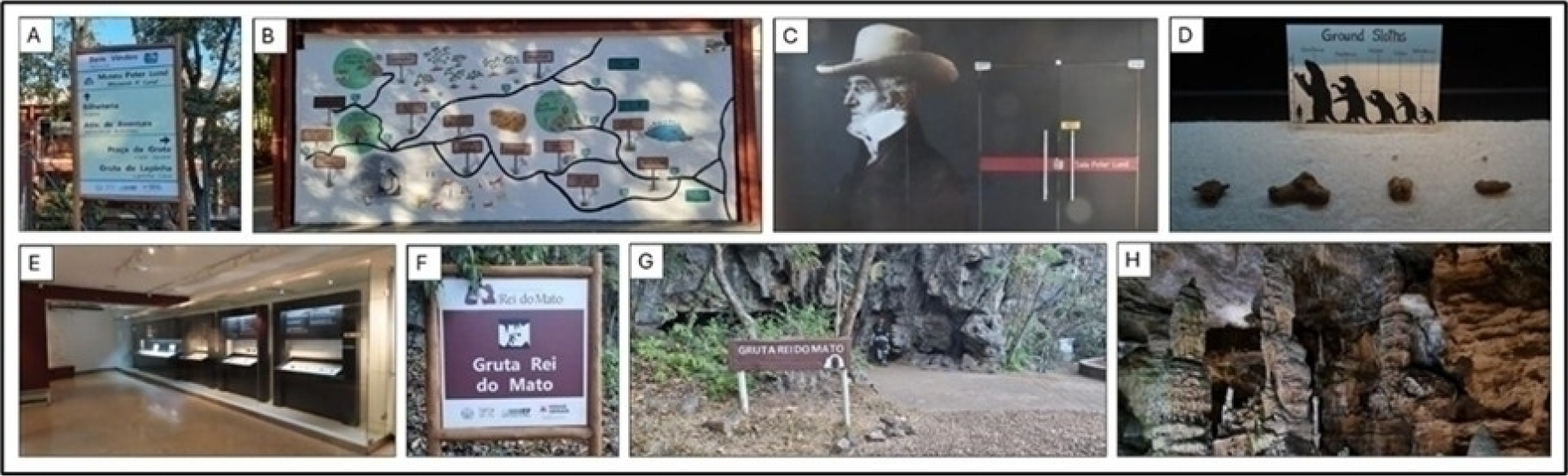
In the case of the Circuito das Grutas de Minas Gerais, the results demonstrate a fragmented and uneven geoterritorialization process, with a strong concentration of documentation, protection, and valorisation actions around three main caves (Lapinha, Maquiné, and Rei do Mato) (Figures 3a-3h). Applying the criteria of Hobléa et al. (2021) reveals that, although there are punctual advances-especially in scientific documentation and selective tourism infrastructure-systematisation, institutional articulation, and the symbolic projection of the territory as a whole are lacking.
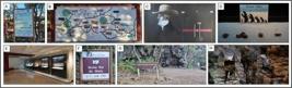
Overview of information provided in the Circuito das Grutas. (a) Informative sign with the location of attractions and activities. (b) Location map illustrated by a regional artist. (c) Entrance of the Peter Lund Museum. (d) Detail of one of the paleontological specimen exhibitions. In the exhibition, the same pattern (e) that provides information about the specimens can be identified. (f-g) Signs along the path and at the entrance of Rei do Mato Cave. (h) Details of speleothems, the cave's main attractions. Their genesis and formation are addressed only orally by guides, as in all three caves of the Circuit (Photos: the authors).
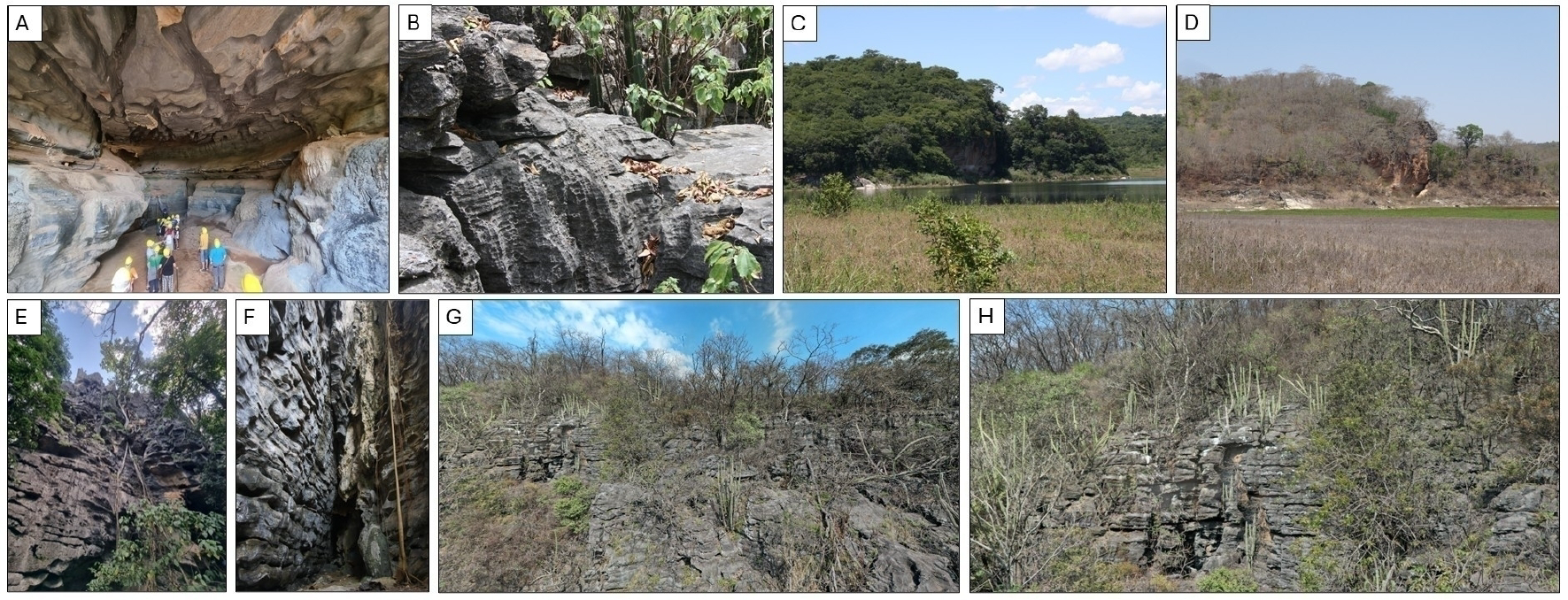
The absence of integrated geoheritage inventories, the low consolidation of participatory management, and the fragility of geoeducation and territorial specification actions limit the Circuit’s potential as a geoterritory. Even with an expressive landscape collection-including limestone cliffs, dolines, uvalas, and other characteristic karst forms-these elements have not yet been strategically incorporated into public policies or the regional tourism offer, remaining limited to occasional and unarticulated uses (Figure 4).
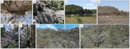
General aspects of the karst of the geoterritory. None of the features mentioned here is explored in detail along the Circuito das Grutas. (a) Features that evidence the period of paragenetic evolution at the entrance of Lapinha Cave, in Lagoa Santa. (b) Various types of karren in the Lapinha Cave massif. Research on these features has been published, but they have not been pedagogically explored within the geoterritory. (c-d) The same holds for karst hydrological seasonality. Its existence is known, but it has not been systematically explored. (e-f-g-h) Significant exokarst aspects of Rei do Mato Cave, in Sete Lagoas. In all photos, the variety of dissolution features associated with karst genesis is evident (Photos: the authors).
To better understand these disparities, we prepared a synthesis of the nine criteria of Hobléa et al. (2021) applied to the Circuito das Grutas (Table 3). The table shows that, although the region has extensive scientific documentation and a relatively consolidated normative base, such advances remain poorly articulated with management and territorial valorisation strategies. Criteria linked to protection and geotouristification are at an intermediate level, whereas aspects central to consolidating a geoterritory-such as inventorying, geoeducation, and territorial specification-are incipient. Thus, the geoterritorialization process, although underway, lacks political directionality, regional cohesion, and symbolic instruments capable of sustaining a shared territorial identity. The challenge, therefore, lies in overcoming this still partial valorisation and advancing toward an integrated approach that articulates science, identity, governance, and sustainability around regional geoheritage.
Synthesis of geoterritorialization criteria (HOBLÉA et al., 2021) applied to the Circuito das Grutas. Source: Organised by the authors.
CONCLUSION
This study demonstrated that the geoterritorialization process in the Circuito das Grutas de Minas Gerais is in its initial stage, with limited progress in scientific documentation, legal protection, and localised tourism infrastructure. Still, it is marked by gaps in systematic inventorying, geoeducation, territorial specification, and integrated management. Regional governance remains fragile and poorly participatory, which limits the construction of a cohesive, socially recognised geoterritory.
Despite carrying in its name a direct reference to geodiversity-Circuito das Grutas-the territory still does not translate this geocultural identity into effective practices of geoheritage valorisation and management. Nevertheless, the analysed set exhibits significant latent potential. The diversity of geosites, the expressiveness of the karst landscape, existing facilities, and the accumulated technical and institutional collection constitute a solid basis for structuring an integrated territorial project.
In this sense, the Australian GeoRegions proposal (OAM, 2023) offers a viable methodological alternative for contexts that do not yet meet the requirements for a Global Geopark. Due to its progressive and participatory character, this model can guide intermunicipal territorial management plans, favour the inclusion of geoheritage in public policies, and strengthen geoeducation as an instrument of identity and regional belonging.
Complementarily, as highlighted by Ruchkys and Auler (2025), the planned use of existing financial instruments-such as the Financial Compensation for Mineral Exploitation (CFEM) and speleological compensations-represents a concrete opportunity to sustain geoconservation and geotourism actions at a regional scale. The strategic redirection of these resources would expand policy implementation capacity and promote greater social and institutional legitimacy.
Consolidating the Circuito das Grutas as a geoterritory, therefore, requires going beyond inventory and protection. It implies connecting, communicating, and educating to transform geoheritage into a vector of territorial cohesion and sustainable development. The adoption of progressive valorisation strategies, articulated with national financial mechanisms and social participation, constitutes the most promising path for the region to overcome its current fragmentation and achieve effective recognition at national and international levels.
ACKNOWLEDGEMENTS
Úrsula de Azevedo Ruchkys and Luiz Eduardo Panisset Travassos thank the National Council for Scientific and Technological Development (CNPq) for Research Productivity Fellowships. Úrsula de Azevedo Ruchkys thanks the Coordination for the Improvement of Higher Education Personnel (CAPES) for the Senior Visiting Fellowship Abroad, carried out at the University of Burgundy, in Dijon, France.
DATA AVAILABILITY
Not applicable.
REFERENCES
-
ALT, L. R.; LOBO, H. A. S.; MOURA, V. M. A. Relevância socioeconômica das cavernas turísticas brasileiras: cenário geral e impactos da pandemia SARS-COV-19. Caderno de Geografia, v. 34, n. 76, p. 349-372, 2024.DOI: https://doi.org/10.5752/p.2318-2962.2024v34n76p349
» https://doi.org/10.5752/p.2318-2962.2024v34n76p349 - ARAUJO, H. R. Propostas para o desenvolvimento sustentável do espeleoturismo no Brasil: estudo comparativo com a experiência portuguesa. Tese (Doutorado em Geografia) - Instituto de Geografia e Ordenamento do Território, Universidade de Lisboa, Lisboa, 2019.
-
ARRUDA, Í. R. P. de; MARIANO, G.; GUIMARÃES, T. de O.; LISTO, D. G. da S. Aplicação da Geodiversidade e suas abordagens no geopatrimônio pernambucano: um estudo de caso. Revista de Geociências do Nordeste, v. 10, n. 1, 2024. DOI: https://doi.org/10.21680/2447-3359.2024v10n1ID33292
» https://doi.org/10.21680/2447-3359.2024v10n1ID33292 - BARBOSA, C. S. Gestão da paisagem cultural: desafios e perspectivas diante do processo de metropolização na APA Carste de Lagoa Santa/MG. Tese (Doutorado em Arquitetura) - Programa de Pós-Graduação em Arquitetura, Universidade Federal de Minas Gerais, Belo Horizonte. 2021. 292p.
- BERBERT-BORN, M. Carste de Lagoa Santa, MG - berço da paleontologia e da espeleologia do Brasil. In: SCHOBBENHAUS, C.; CAMPOS, D. A.; QUEIROZ, E. T.; WINGE, M.; BERBERT-BORN, M. (Org.). Sítios geológicos e paleontológicos do Brasil. Brasília: Departamento Nacional de Produção Mineral (DNPM), 2002. p. 415-424.
-
CIRCUITO DAS GRUTAS. Circuito Turístico das Grutas. s.d. Disponível em: https://circuitodasgrutas.com.br/
» https://circuitodasgrutas.com.br/ -
CLAUDINO-SALES, V. de. Geodiversidade e Geopatrimônio em uma leitura geográfica. Revista de Geografia (Recife), v. 41, n. 5, 2024. DOI: https://doi.org/10.51359/2238-6211.2024.261941
» https://doi.org/10.51359/2238-6211.2024.261941 - CVIJIC, J. Carste: Uma monografia geográfica (1895). Belo Horizonte: PUC Minas, 2017. Tradução de Luiz Eduardo Panisset Travassos.
-
DANTAS, M. E.; ARMESTO, R. C. G.; SILVA, C. R.; SHINZATO, E. Geodiversidade e análise da paisagem: uma abordagem teórico-metodológica. Terrae Didatica, v. 11, n. 1, p. 04-13, 2015. Disponível em: http://www.ige.unicamp.br/terraedidatica/
» http://www.ige.unicamp.br/terraedidatica/ -
DOUMIT, L. La valorisation du patrimoine endokarstique libanais. Thèse de Géographie - Université de Savoie; Université Saint-Joseph, Beyrouth. 2007. Disponível em: https://theses.hal.science/tel-00273992
» https://theses.hal.science/tel-00273992 -
DUVAL, M. Dynamiques spatiales et enjeux territoriaux des processus de patrimonialisation et de développement touristique. Étude comparée des gorges de l’Ardèche et du Karst slovène. Thèse de Géographie- Université de Savoie, 2007. Disponível em: https://theses.hal.science/tel-00200563/
» https://theses.hal.science/tel-00200563/ -
FORD, D. C.; WILLIAMS, P. Karst hydrogeology and geomorphology. Chichester: John Wiley, 2007. 562p. DOI: https://doi.org/10.1002/9781118684986
» https://doi.org/10.1002/9781118684986 -
GRAY, M. Case studies associated with the 10 major geodiversity-related topics. Philosophical Transactions of the Royal Society, v. 382, 2024. DOI: https://doi.org/10.1098/rsta.2023.0055
» https://doi.org/10.1098/rsta.2023.0055 -
GUIMARÃES, T. de O.; MOURA-FÉ, M. M. de; ALMEIDA, R. R. de. Geopatrimônio: por quê? Para quê? Para quem? PerCursos, v. 23, n. 52, 2022. DOI: https://doi.org/10.5965/198472462352022332
» https://doi.org/10.5965/198472462352022332 - HERMANN, G.; KOHLER, H. C.; DUARTE, J. C.; CARVALHO, P. G. S. (Org.). Gestão ambiental (Série APA Carste de Lagoa Santa - MG). Belo Horizonte: IBAMA/Fundação BIODIVERSITAS; CPRM, 1998. 40p.
-
HOBLÉA, F.; CAYLA, N.; PEYRACHE-GADEAU, V.; ROUSSET, P.; BARBARIN, B.; BOURGEOIS, A.; KRUPKA, P.; TALIBART, C. Territorialisation du géopatrimoine en région Auvergne-Rhône-Alpes (France). Géo-Regards - Géopatrimoines et territoires, n. 14, 2021, p. 15-34. DOI: https://doi.org/10.33055/GeoRegards.2021.014.01
» https://doi.org/10.33055/GeoRegards.2021.014.01 - HOSE, T. A. Selling the story of Britain's stone. Environmental Interpretation, n.10, v.2, 1995, p.16-17.
- HOSE, T. A. European geotourism - geological interpretation and geoconservation promotion for tourists. In: BARETTINO, D.; VALLEJO, M.; GALLEGO, E. (Ed.). Geological heritage: its conservation and management. Madrid: Instituto Tecnológico GeoMinero de España, 2000. p. 127-146.
-
KUBALÍKOVÁ, L.; VANDELLI, V.; PÁL, M. New horizons in geodiversity and geoheritage research: bridging science, conservation, and development. Moravian Geographical Reports, v. 33, n. 1, p. 2-6, 2025. DOI: https://doi.org/10.2478/mgr-2025-0001
» https://doi.org/10.2478/mgr-2025-0001 -
LANDEL, P.A.; SENIL, N. Patrimoine et territoire, les nouvelles ressources du développement. Développement durable et territoires, v. 12, 2009. DOI: https://doi.org/10.4000/developpementdurable.7563
» https://doi.org/10.4000/developpementdurable.7563 -
LAPLANTE, M. Le patrimoine en tant qu’attraction touristique: histoire, possibilités et limites. In: NEYRET, R. (Org.). Le patrimoine, atout du développement. Lyon: Presses universitaires de Lyon, 1992. p.49-61. DOI: https://doi.org/10.4000/books.pul.37682
» https://doi.org/10.4000/books.pul.37682 - MARTEL, E. A. Nouveau traité des eaux souterraines. Paris: Éditions Doin, 1921. 840p.
- OLIVEIRA, A.P.G.S. de. Conectando trechos do caminho: turismo, lazer e desenvolvimento regional no contexto do projeto estruturador Rota das Grutas de Peter Lund - MG. Tese (Doutorado em Educação Física) -Escola de Educação Física, Fisioterapia e Terapia Ocupacional, Universidade Federal de Minas Gerais, Belo Horizonte. 2018. 199p.
-
OAM, H. J. Guidelines for the development of GeoRegions. National Geotourism Strategy of the Australian Geoscience Council. 2023. Disponível em: https://www.agc.org.au/wp-content/uploads/2023/12/GUIDELINES-FOR-THE-DEVELOPMENT-OFGEOREGIONS_finalrelease.pdf
» https://www.agc.org.au/wp-content/uploads/2023/12/GUIDELINES-FOR-THE-DEVELOPMENT-OFGEOREGIONS_finalrelease.pdf -
REYNARD, E.; BUSSARD, J. Le géopatrimoine et ses dimensions territoriales. Géo-Regards - Géopatrimoines et territoires, n. 14, 2021, p. 5-13. DOI: https://doi.org/10.33055/GeoRegards.2021.014.01
» https://doi.org/10.33055/GeoRegards.2021.014.01 -
RUBAN, D. A. Karst as an important resource for geopark-based tourism: Current state and biases. Resources, v. 7, n. 4, p. 82, 2018. DOI: https://doi.org/10.3390/resources7040082
» https://doi.org/10.3390/resources7040082 -
RUCHKYS, Ú. de A.; AULER, A. S. Geoparks in Brazilian karst areas: institutional scenarios and multilevel governance strategies. Environmental Earth Sciences, v. 84, p. 437, 2025. DOI: https://doi.org/10.1007/s12665-025-12435-6
» https://doi.org/10.1007/s12665-025-12435-6 -
RUCHKYS, Ú. de A.; OLIVEIRA, C. K. R.; JARDIM, H. L.; JORGE, L. M. de S. Abordagem metodológica da geodiversidade e de temas correlatos em Geossistemas Ferruginosos. Caderno de Geografia, v. 28, n. esp. 1, 2018. DOI: https://doi.org/10.5752/P.2318-2962.2018v28nespp1
» https://doi.org/10.5752/P.2318-2962.2018v28nespp1 - SANTOS, M. A natureza do espaço: técnica e tempo, razão e emoção. 4.ed., 2ª reimpr. São Paulo: Editora da Universidade de São Paulo, 2006.
-
SENA, Í. S. de; RUCHKYS, Ú. de A.; TRAVASSOS, L. E.P. Geotourism potential in karst geosystems: An example from the Lund Warming Ramsar Site, Minas Gerais, Brazil. Catena, v. 208, p. 105717, 2022. DOI: https://doi.org/10.1016/j.catena.2021.105717
» https://doi.org/10.1016/j.catena.2021.105717 - SILVA, H. V. M. da; AQUINO, C. M. S. de; AQUINO, R. P. de. Avaliação do geopatrimônio do município de Juazeiro do Piauí, Piauí, Brasil. Observatorium: Revista Eletrônica de Geografia, v. 15, 2024.
- SOUZA, M. L. de. O Território: sobre espaço e poder, autonomia e desenvolvimento. In: CASTRO, I. E. de; GOMES, P. C.; CORRÊA, R. L. (Org.). Geografias: conceitos e temas. Rio de Janeiro: Bertrand Brasil, 2009.
- TAVARES, D. E. da S. Governança e desenvolvimento do turismo: análise da instância de governança regional Grutas/MG. Dissertação (Mestrado em Turismo) - Universidade Federal Fluminense, Faculdade de Turismo e Hotelaria, Niterói. 2024. 212 p.
-
TRAVASSOS, L. E. P. Princípios de carstologia e geomorfologia cárstica. Brasília: ICMBio, 2019. 242 p. Disponível em: https://www.gov.br/icmbio/pt-br/assuntos/centros-de-pesquisa/cavernas/publicacoes/cecav_principiosdecarstologia.pdf
» https://www.gov.br/icmbio/pt-br/assuntos/centros-de-pesquisa/cavernas/publicacoes/cecav_principiosdecarstologia.pdf
Edited by
-
Editors in Charge
Alexandra Maria OliveiraAlexandre Queiroz Pereira Eduardo Von Dentz