 URBAN WATERSHED MANAGEMENT IN THE BRAZILIAN AMAZON
Abstract
The Tucunduba Hydrographic Basin (THB) is the second-largest basin in Belém, Pará, draining four densely populated neighborhoods-Marco, Canudos, Terra Firme, and Guamá-with an estimated population of approximately 200,000 inhabitants. This study aims to analyze the socio-environmental conditions of the THB by examining key macro-environmental factors essential to understanding the basin's dynamics. The methodological approach involved conducting 44 interviews with THB residents to assess their socio-environmental perceptions, applying the Simplified Environmental Impact Assessment (SEIA), and estimating per capita sewage discharge across the neighborhoods within the basin. The findings indicate that the Quality of Urban Life Index in the study area is approximately 0.6, reflecting moderate living conditions. The SEIA further revealed substantial environmental impacts, classified as high or very high. These results underscore the inadequacy of public services provided to the local population and highlight the fragility of urban management. Urgent measures are needed to implement an integrated management strategy for the THB, enhance environmental monitoring, and improve service provision to ensure a high quality of life and a healthier environment.
Keywords:
Integrated Management; Environmental impacts; Macrodrainage; Quality of life
Resumo
A Bacia Hidrográfica do Tucunduba (BHT) é a segunda maior bacia de Belém, Pará, drenando quatro bairros (Marco, Canudos, Terra Firme e Guamá), com uma alta densidade populacional de aproximadamente 200.000 habitantes. Este estudo tem como objetivo analisar as condições socioambientais da BHT, examinando os principais fatores macroambientais essenciais para compreender a dinâmica da bacia. A abordagem metodológica envolveu a realização de 44 entrevistas com moradores da BHT para avaliar suas percepções socioambientais, a aplicação da Avaliação Simplificada de Impacto Ambiental (ASIA) e a estimativa da carga de esgoto per capita nos bairros situados dentro da bacia. Os resultados indicam que o Índice de Qualidade de Vida Urbana na área estudada é de aproximadamente 0,6, refletindo condições de vida moderadas. A ASIA também revelou impactos ambientais significativos, classificados como altos ou muito altos. Esses achados evidenciam a inadequação dos serviços públicos prestados à população local e a fragilidade da gestão urbana. Medidas urgentes são necessárias para a implementação de uma estratégia integrada de gestão da BHT, aprimoramento do monitoramento ambiental e melhoria na prestação de serviços, garantindo uma melhor qualidade de vida e um ambiente mais saudável.
Palavras-chave:
Gestão Integrada; Impactos Ambientais; Macrodrenagem; Qualidade de Vida
Resumen
La Cuenca Hidrográfica de Tucunduba (CHT) es la segunda cuenca más grande de Belém, Pará, y abarca cuatro barrios densamente poblados-Marco, Canudos, Terra Firme y Guamá-con una población estimada de aproximadamente 200 mil habitantes. Este estudio tiene como objetivo analizar las condiciones socioambientales de la CHT, examinando los principales factores macroambientales esenciales para comprender la dinámica de la cuenca. El enfoque metodológico incluyó la realización de 44 entrevistas con residentes de la CHT para evaluar sus percepciones socioambientales, la aplicación del Evaluación Simplificada de Impacto Ambiental (ESIA) y la estimación de la carga de aguas residuales per cápita en los barrios dentro de la cuenca. Los resultados indican que el Índice de Calidad de Vida Urbana en el área de estudio es de aproximadamente 0,6, lo que refleja condiciones de vida moderadas. La ESIA también reveló impactos ambientales significativos, clasificados como altos o muy altos. Estos hallazgos evidencian la insuficiencia de los servicios públicos prestados a la población local y la fragilidad de la gestión urbana. Se requieren medidas urgentes para implementar una estrategia de gestión integrada de la CHT, mejorar el monitoreo ambiental y optimizar la prestación de servicios, garantizando una mejor calidad de vida y un entorno más saludable.
Palabras-clave:
Gestión Integrada; Impactos Ambientales; Macrodrenaje; Calidad de Vida
INTRODUCTION
The development of urban centers in the western world was marked by the consequent unbridled exploitation of natural resources, resulting in the modern consumer society (PELIZZOLI, 1999). These urban centers were often installed close to rivers and lakes, exerting great pressure on these systems and carrying an outstanding environmental responsibility to comply with their demands and waste production (SILVA; AZEVEDO; MATOS, 2006).
According to Souza and Ottoni (2015), the urbanization process combined with the lack of adequate management is the main reason for the degradation of water resources, generating social and environmental impacts. In Brazil, most environmental issues affecting the hydrographic basins stem from the lack of environmental commitment and inadequate public policies, norms, and specialized personnel. These factors generate deep vulnerabilities regarding environmental and social impacts (ARAÚJO et al., 2009).
Enacting the Water Law (Law No. 9,433/97) was crucial to achieving better water resource management in Brazil. This law introduced the National Water Resources Policy (PNRH), the National Water Resources Management System (SINGREH), and the National Water Agency (ANA), which have all played essential roles in regulating watersheds. By this law, a watershed is now considered a territorial unit for implementing PNRH and SINGREH’s activities.
A hydrographic basin is a complex system of social, economic, cultural, and environmental interactions that directly impacts the use of water resources (YASSUDA, 1993). In Brazil, the hydrographic basin is recognized as a Water Resources Management Unit in which the hydrographic basin committees seek to promote: 1) site planning, 2) water-use regulation, and 3) basin’s catchment sources protection and conservation (PORTO; FERREIRA, 2012).
A watershed is a natural area that collects and directs water through drainage channels, with the flow depending on rainfall and the balance between infiltration and evaporation (CHRISTOFOLETTI, 1980). According to the Federal Interagency Stream Restoration Working Group (1998), watercourses are critical components of watersheds. They provide habitat for organisms; filter for the entry of materials, animals, or energy into the ecosystem; transport energy, animals, and materials through water flow; act as a barrier between habitats; supply organic and sedimentary matter; regulate the local climate; and function as a sink and water runoff to other locations.
Historically, cities worldwide emerged near watercourses since rivers played essential functions in meeting social demands such as water supply, irrigation, transportation, food, and leisure. According to Farias and Medonça (2022), urban flooding results from the unplanned occupation of urban space and the inefficiency of drainage systems. In this context, the execution of macro drainage projects has been used as an intervention strategy to control floods and mitigate their outcomes through structural and non-structural actions. A macro drainage network consists of navigable water bodies with flow equal to or greater than 20m3/s, which are also floatable and provide public water for common use (SOUZA; OTTONI, 2015). These projects aim to reduce the risks and losses in large areas (such as those adjacent to major watercourses) that are susceptible to floods with relatively long return periods (typically T= 25 to 100 years) (SOUZA; OTTONI, 2015).
TUCUNDUBA RIVER BASIN
The city of Belém comprises 14 urban hydrographic basins, with Tucunduba Hydrographic Basin (THB) being the second-largest. The THB drains four neighborhoods: Marco, Canudos, Terra Firme, and Guamá. Ferreira (1995) reports that until the mid-20th century, THB was sparsely occupied, with houses constructed using wood and straw. During this period, it was still possible to use the river for recreational activities such as bathing, leisure, and water transport.
The THB is one of the most densely populated areas of the city, with a population of approximately 200,000 inhabitants, and is surrounded by several enterprises, such as wood, tile, brick, and coal traders, as well as açaí vendors. These products are transported across the river to local fairs and businesses (TARGA, 2012).
In 2008, the THB macrodrainage project was initiated to minimize the impact of flooding in the region. The project included the pavement of roads, the construction of ten bridges and 400 housing units, a nursery, public squares, and courts, as well as canal waterproofing. Additionally, the project involved expanding the water supply system and implementing the sewage and sanitation treatment system, with the construction of a Sewage Treatment Station for 4,000 families (TARGA, 2012). However, the construction projects were modified over time and, at times, were even paralyzed due to changes in administration.
The Tucunduba Macrodrainage Project (TCDP) was developed to carry out infrastructural actions to guarantee a better quality of life for residents in the intervention area. Currently, it is being executed by the Government of the State of Pará in partnership with the City Hall of Belém, with Caixa Econômica Federal as the financially responsible party and the Secretaria de Estado de Desenvolvimento Urbano e Obras Públicas (SEDOP) as the executing agency. The Companhia de Habitação do Estado do Pará (COHAB) is in charge of the housing project, and Urbaniza Ltda executes social project activities. In January 2021, this phase was completed, and SEDOP concluded negotiations with residents, advancing to the third stage of the TCDP (TARGA, 2012).
The assumptions that guided this research were based on the hypothesis that the modification of natural processes and landscape dynamics within the Tucunduba watershed, primarily resulting from the macro drainage work, leads to structural changes in geosystems that result in negative impacts on the communities within the basin. Thus, this research aimed to analyze the socio-environmental conditions of the Tucunduba Hydrographic Basin in terms of macro-environmental elements (environmental quality, services, and infrastructure) required to understand the usage dynamics within the basin.
METHODOLOGY
STUDY AREA
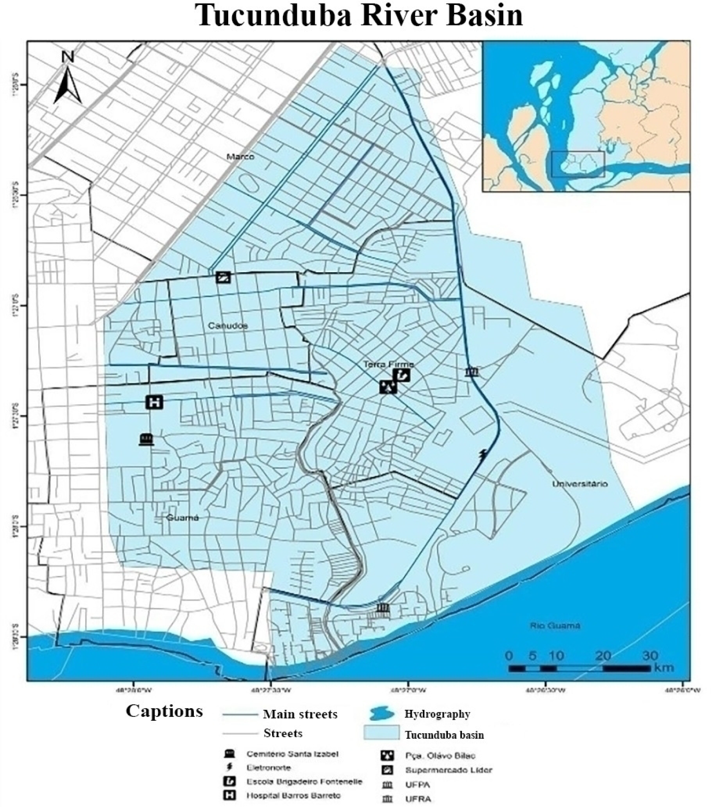
The Tucunduba Hydrographic Basin is situated in the southern area of Belém, covering a total area of 10.55 km2 and 3,600 meters (see Figure 1).
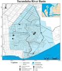
This basin drains four peripheral districts of the city: Marco, Canudos, Terra Firme, and Guamá. According to the IBGE (2010), Belém has approximately 1,393,399 inhabitants, with three of the ten most populous neighborhoods in the city located in the Tucunduba basin area, namely: Guamá (94,610 inhabitants - 25,703 households), Marco (65,844 inhabitants - 20,212 households), and Terra Firme (61,439 inhabitants - 16,439 households).
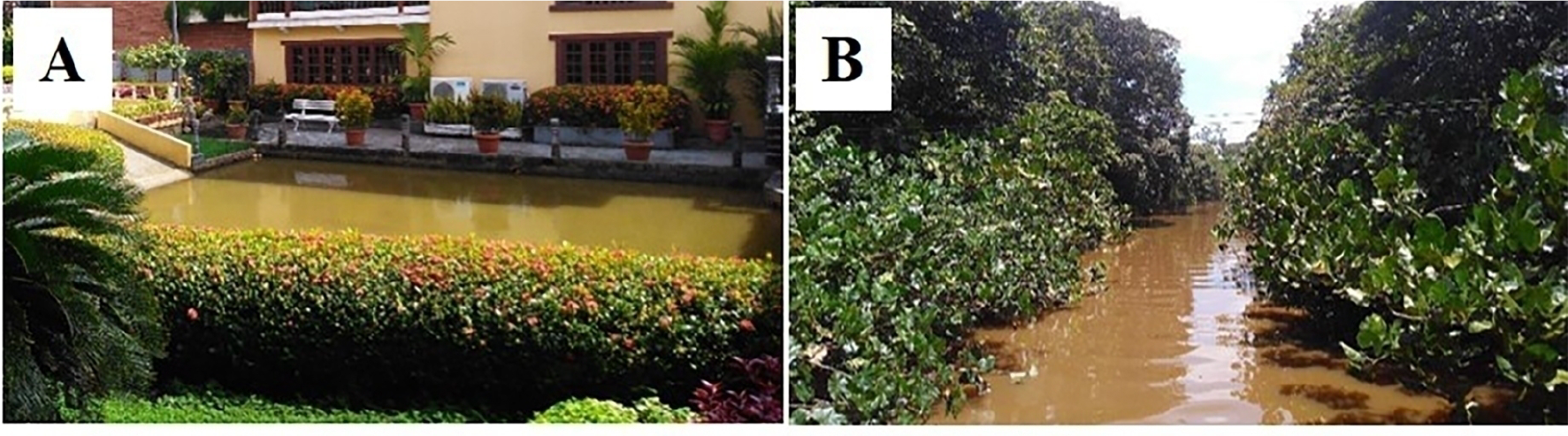
The neighborhood of Marco is situated at one of the sources of the Tucunduba River on Lane Angustura, between Avenue Almirante Barroso and Avenue João Paulo II (see Figure 2A). The mouth of the Tucunduba River is located within the territory of the Universidade Federal do Pará, on the right bank of the Guamá River (see Figure 2B).
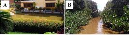
Sections of the Tucunduba River; A) Source of the Tucunduba river inside private property and B) Mouth of the Tucunduba river. Source: Authors.
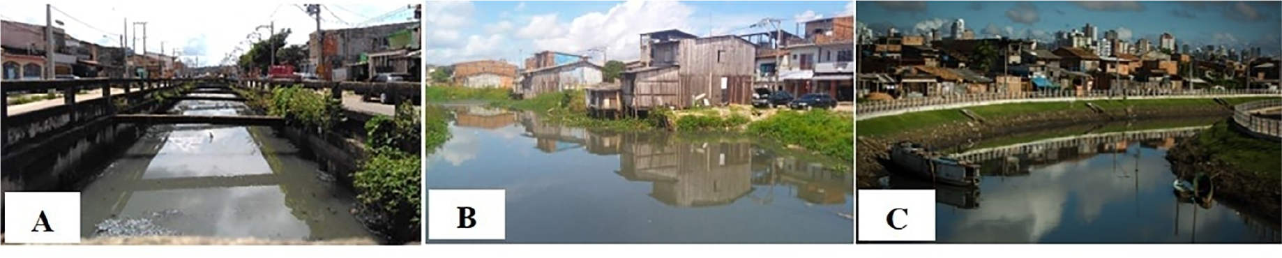
Along the basin, each neighborhood has unique characteristics shaped by urban interventions that modify the landscape and land uses, as illustrated in Figure 3A for the well-known Cipriano Santos Canal in the Canudos neighborhood, Figure 3B for Avenue Celso Malcher in the Terra Firme neighborhood, and Figure 3C for Passagem Tucunduba in the Guamá neighborhood. These figures show the neighborhoods at distinct stages /of development.
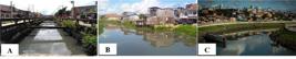
Sections of the Tucunduba River A) Cipriano Santos Canal, Canudos neighborhood. B) Avenue Celso Malcher, Terra Firme neighborhood 2018. C) Passagem Tucunduba, Guamá neighborhood. Source: Authors.
THB RESIDENT’S SOCIO-ENVIRONMENTAL PERCEPTION
A survey was conducted to understand the reality of the local population, assess the availability of public services, identify the main anthropic activities, and examine their socio-environmental impacts based on the resident’s perception of the services and infrastructure in each neighborhood (Guamá, Terra Firme, Canudos, and Marco). Thus, a semi-structured interview consisting of open and closed questions was administered through the Google Forms tool, using electronic devices to access links via WhatsApp (BAUER; GASKELL, 2002).
In addition, e-mails were sent to economically active individuals over 18 years old. The questionnaires were applied by 44 respondents between 2020 and early 2021. The first question referred to the Free and Informed Consent Form (FICF), in which the interviewee was being invited to participate in the research: “Socio-environmental aspects of the Tucunduba Hydrographic Basin”. And they selected between the options 1) I agree to participate, as a volunteer in the study or 2) I do not agree to participate in this research.
The interview script consisted of 22 questions based on the following aspects: infrastructure conditions and public services availability, relationship to the watershed, residents’ environmental perception, macrodrainage project, and other aspects related to the quality of life in the neighborhood.
In addition, unstructured interviews were conducted with randomly selected neighborhood residents (6-8 residents) to explore specific environmental issues further (RICHARDSON, 1999). This type of interview is characterized by complete openness, flexibility, and a search for meaning based on the interviewee’s perspective, as described by May (2004).
This study employed interviews to assess participants' perceptions of environmental issues within their neighborhood. All responses were anonymized, ensuring the absence of any personally identifiable information. In accordance with CNS Resolution No. 510/2016, Article 1, Item II, research based on voluntary reports addressing non-sensitive topics, with no associated risks to participants and without the collection of identifiable data, does not require submission to the Research Ethics Committee.
SIMPLIFIED ENVIRONMENTAL IMPACT ASSESSMENT
The Simplified Environmental Impact Assessment (SEIA) method was applied to understand the impacts inherent to human occupation, following the methodology of Salles et al. (2008) and Sardinha et al. (2010). The AAS (Table 1) relates land occupation and use (including elimination or modification of vegetation cover and fauna) to water quality parameters, such as physical, chemical, and visual parameters.
Environmental indicators and their respective weights applied in the Tucunduba River Basin/PA. Source: Adapted from Sardinha et al. (2010).
The data to apply the AAS were obtained through a bibliographical survey on the current uses of water resources in the Tucunduba River basin, direct observation on site (in loco), and analysis of satellite images. This step allowed for environmental characterization and survey of the elements that represented the impacts in the analyzed region, which was divided into three sampling stations (P1, P2, and P3). It is worth mentioning that the selection of sampling stations is related to the stages of the macrodrainage work on the Tucunduba River. Specific questions were also addressed in interviews.
After recording the weights for each indicator (modified from Sardinha et al., 2010), a score was assigned to each studied parameter. The range of scores varied from 0 (minimum) to a maximum of 24. The higher the score, the lower the level of impact in the region studied, classified as follows: Very High (0 to 6); High or Concerning (7 to 12); Moderate (13 to 18); and Minimal or Negligible (19 to 24).
The third stage of this research aimed to identify the causes of local environmental impacts and define management strategies for the analyzed areas, using the PER (Pressure-State-Response) model developed by Organization for Economic Cooperation and Development - OECD (2002). This model is based on three fronts: human pressure, the state of the environment, and society’s response divided over three categories of indicators: a) Pressure: existing pressures of human activities on the environment; b) State: environmental conditions, whether qualitative or quantitative and how to improve these indicators; c) Response: reaction of the population to changes in environmental conditions through actions taken to mitigate environmental pressures, leading to an improvement in the environment.
PER CAPITA SEWAGE DISCHARGE
Microbiological studies are essential for assessing the environmental quality of water bodies. Thus, we estimated the sewage production by the residents of each neighborhood using the Von Sperling method (2007) to understand the possible impacts of the lack of sanitary infrastructure on BHT. Considering that each individual produces about 150 liters of sewage per day in urban areas, the daily production per capita of effluents was calculated using the following formula:
- Effluent discharge (m3/day)
- Per capita sewage discharge (L/day)
RESULTS AND DISCUSSION
TUCUNDUBA RIVER BASIN: A VIEW OF THE RESIDENTS
Historically, the Tucunduba River Basin was initially occupied through institutional lands owned by the Federal Government (Universidade Federal do Pará, Empresa Brasileira de Pesquisa Agropecuária, and Museu Paraense Emílio Goeldi). Later, migrant populations from rural areas of Pará spontaneously occupied these lands, necessitating intervention. During this period, the basin was used for water supply, waste disposal, navigation, leisure, and fishing (SILVA, 2016).
The high population concentration in the area has transformed the streams of the Tucunduba River into channels for the flow of domestic effluents due to anthropic pressure that altered its bed by increasing the density of urban constructions, reducing vegetation cover, waterproofing the soil, and facilitating garbage disposal and sewage.
The interviewees highlighted the impacts of these alterations and the essential public services and infrastructure needed to improve the quality of life of residents along the Tucunduba Basin. Such services include the urgent need for a sewerage system, water supply, drainage, and neighborhood security. The priority order of these services varies among neighborhoods, especially in peripheral areas like Guamá and Terra Firme. In the Terra Firme neighborhood (Table 2), the items with the highest proportion of implementation were the sewerage system and the construction of schools, both with 87%, followed by drainage (82.6%), health units (78.2%), and water supply and security with 65%.
Table 2 shows that in the Guamá neighborhood, around 94% of respondents identified Security as an item that requires implementation or improvement. Following that, approximately 87.5% of respondents mentioned the need for sewerage systems, 81.2% for drainage, and 68.8% for services like water supply, garbage collection, and the establishment of schools.
Participants in the Marco neighborhood indicated that bike lanes, leisure areas, and broader sidewalks are necessary. In the neighborhood of Canudos, all interviewees stated that Security and Water Supply need to be provided, and 75% of them mentioned the need for sewerage systems and health units. The interviewees believe that the other items are adequately supplied to the residents.
The provision of infrastructure services in some neighborhoods, such as Canudos and Marco, was more satisfactory, while in more peripheral areas like Guamá and Terra Firme, the service is more precarious. It highlights the need for more effective and efficient public management to improve the quality of life for residents. For instance, when asked about the regularity of garbage collection in their neighborhoods, 43.5% of respondents from Terra Firme reported that their street’s garbage is collected regularly, while 56.5% stated that it is collected irregularly. Of those surveyed, 65.2% reported that garbage is collected three times a week, and 34.8% reported that it is collected twice weekly.
Regarding garbage collection in the Guamá neighborhood, 50% of the interviewed residents stated that it is carried out on an irregular basis, while 50% stated otherwise. Among those who reported regular collection, 12.5% stated that waste is collected more than three times a week, 43.8% three times a week, and 37.5% twice a week. These differences in responses can be explained by the periodicity of collections, which may vary depending on the street or area. Some streets are too narrow for the waste collection trucks to access, leading to irregularities.
The interviewees reported that, in this scenario, the accumulation of waste in inappropriate places (see Figure 4) could be even more aggravated and could lead to its transport to the watercourse, especially during heavy rains and flooding.
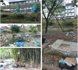
Photos depicting the disposal of waste on the margins of the Tucunduba River in Section 1 of Stage 1. Source: Authors.
In the Terra Firme neighborhood, 21.7% stated that their street constantly floods, 69.6% indicated that it floods at certain times, and 8.7% stated it does not. The same pattern occurs in the neighborhood of Guamá, as 6.2% of respondents reported constant flooding, 68.8% stated that flooding on their street occurs at certain times, and only 25% said it does not. Most of the respondents reported experiencing flooding in the Tucunduba basin. This issue is due to the high degree of urbanization in the area, resulting in a faulty drainage system and non-permeable soil. These factors create a favorable scenario for floods to occur during different flood regimes in the basin (MARINHO; SARAIVA; RODRIGUES, 2015; RODRIGUES, 2019).
The problem of flooding in the Tucunduba basin has several negative consequences, including exposure to contaminated water and an increased risk of waterborne diseases. It can result in economic and psychological damage to the affected residents (MARINHO; SARAIVA; RODRIGUES, 2015). The material damages are also significant, with the destruction of buildings, vehicles, furniture, and household items, loss of perishable food, traffic obstruction, and even interruptions in energy service.
According to the interviewees, the Tucunduba Macrodrainage Work, initiated in 1991 as a management strategy to minimize social problems in the THB, remains a source of controversy in the area. The work has changed the environment and common land use practices in previous decades, such as using the Tucunduba River for bathing (FERREIRA, 1995). The project has also improved the landscape, resulting in a more organized space. However, some interviewees have reported several environmental and social issues regarding pollution, decreased aquatic species, and flooding. The following are quotes from some interviewees about the changes in the THB over time:
“In a brief historical account, I know that my family (brothers) and neighbors bathed in the Tucunduba stream around the 70s and 80s. In this way, they claim that the igarapé presented conditions of use aimed at primary contact recreation (bathing) and diversity of fish species. (...)” (Resident 1)
“My parents say that people used to bathe in the river before. Well, especially in recent years, the Tucunduba work has progressed, and the space is much prettier, more organized, and cleaner.” (Resident 2)
“There was an increase in river pollution and a shortage of animals, which were many.” (Resident 3)
“Floods have become more frequent. Houses have caved in more and are falling below street level in some parts.” (Resident 4)
The environmental modifications cited by residents corroborate Ferreira (1995) description of the landscape in the Tucunduba basin, which consisted of many native trees, flowers, animals, and a diversity of fish, as well as a floodplain forest. Regarding the macrodrainage work, the main aspects of the infrastructure were asked, which were grouped into two analysis criteria: negative aspects and positive aspects (Table 3).
The improvements most frequently cited by residents were related to flooding (40.9%) and traffic (25%). Flooding is a pervasive problem in urban areas, particularly in the outskirts, due to inadequate infrastructure, planning, and management of watercourses that run through cities. The occupation of riverbanks, canalization, and soil sealing exacerbates the risks associated with flooding. In the case of THB, the macrodrainage work was specifically designed to alleviate these issues, yet persistent flooding suggests that more action may be needed to mitigate the problem.
“Some areas have improved in terms of flooding and the structures of the streets in the neighborhood, especially the houses close to the canal.” (Resident 5)
“The main improvement I see refers to the issue of flooding in the roads, allowing for better rainwater drainage.”(Resident 6)
The residents most mentioned negative aspects related to the social aspect of the Tucunduba project (29.5%) and the persistent flooding (20.4%) in certain river sections. Concerning the social aspect, several issues were raised, including inadequate compensation or social rent, delayed or undelivered housing developments, inadequate planning, lack of effective measures to assist affected families, and lack of consultation with the community when making housing decisions (AMORIM et al., 2007; MARINHO; SARAIVA; RODRIGUES, 2015).
The situation in THB is similar to other basins undergoing macrodrainage processes, such as the Maranguapinho River Hydrographic Basin in Fortaleza. The Maranguapinho project has been ongoing since 2009 and is expected to conclude in 2022. Its objective is to improve the socio-environmental conditions of the basin and the living conditions of residents living in high-risk flood zones and areas adjacent to the Maranguapinho River. However, the area faces environmental vulnerabilities, including pollution, water contamination, and siltation, as well as social vulnerabilities, such as inadequate housing, lack of basic sanitation, flooding, and poverty, as reported by Almeida (2010).
Although many residents cited a decrease in flooding as a positive aspect of the macrodrainage work, some noted that flooding has increased, which 20.4% of the respondents identified as a negative aspect. It is important to note that drainage works in urban areas should be carried out with an integrated view of the entire basin, as recommended by Almeida (2010). When the containment of flooding is the primary goal of the work, it is common for flooding to shift to other areas, which may occur in THB.
The issue of flooding in Belém is a complex problem that cannot be solely attributed to the improper disposal of solid waste by the population. Basic sanitation is a significant concern, with Belém having the fourth worst basic sanitation in the country and only 10% of its population having access to it, as reported by the Brazilian Institute of Geography and Statistics in 2015. The Municipality of Belém declared a health and environmental emergency in 2019 due to the absence of a waste disposal facility in the city.
In addition to the impacts already mentioned, many environmental consequences of the macrodrainage works in the basin can be identified, such as the loss of local biodiversity, removal of riparian vegetation, erosion, siltation, soil impermeability, alteration of the microclimate, decrease in surface runoff capacity, and changes in river flow. These impacts have been reported in other studies on macrodrainage works in urban areas, emphasizing the need for sustainable drainage strategies that prioritize the preservation of the ecosystem and its functions, such as retaining rainwater in the area of origin.
SIMPLIFIED ENVIRONMENTAL IMPACT ASSESSMENT
The results show that P1 has an impact index of 8 (Table 4), classified as “high or concerning.” It is attributed to observed environmental degradation during in situ evaluations and the perception of residents, with the impact primarily related to the reduction of riparian vegetation cover in the surrounding area. However, it should be noted that although P1 is classified as having understory vegetation, there are sections with a predominance of partially preserved riparian forest (in institutional areas belonging to the Universidade Federal do Pará up to the Passagem Tucunduba Bridge), as well as a moderate to low presence of animals.
The scenario described or classified above is typical of the urbanization process around watersheds. Similar work conducted in other river basins, such as the Verde River Basin in Brazil (CRUZ, 2020) and the Kishwaukee River Basin in the United States of America (CHOI; DEAL, 2008), has shown that urbanization-induced land use changes and the migration or extinction of native species can impact ecosystem processes, such as primary productivity, decomposition, nutrient cycling, and the ecosystem structure of urban rivers.
P2 (Table 4) shows similarities to P1 in terms of the degradation of riparian vegetation in certain areas, but the most concerning impacts are related to the release of untreated liquid effluents in the BHT vicinity. In both P1 and P2, some parts of the river are also used for navigation, which could explain the moderate presence of foam and oil in these sections (Table 4).
On the other hand, P3 received a Very High impact score (6) due to the absence of vegetation cover, the low presence of native animals, and various issues such as strong odor, excessive garbage along the river banks, and the presence of algae, which may indicate contamination leading to water eutrophication. However, this sample station received a different score for the presence of oil, which is low since this section is no longer navigable due to the narrowing of the channel.
Over time, the evolution of the urbanization process led to population density, the occupation of areas, and the consequent reduction of 75% in the native vegetation area of the Tucunduba River, from 1972 to 2006 (MATOS et al., 2011; TARGA, 2012). These studies showed that in 2006, there was better visibility of the main channel due to the implementation of the macrodrainage plan that started in 2000.
The parameter referring to impacts on water quality, specifically the type of sewage, should be considered since P1 and P3 were classified as having a low presence of pollution due to their drainage and sewage networks, as reported by the residents. However, during the unstructured interviews, it was explained that although waste is collected, it is disposed of in one of the fluvial channels of the Tucunduba River without any treatment. It is worth noting that in P1, where the Liberdade Housing Complex is located, a project to build a treatment plant for this location is underway but has not yet been finalized.
Based on the parameter of solid waste and the excessive presence of materials being discarded in inappropriate places, all sections were found to have a significant amount of dispersed waste. This result confirms the concerns of residents regarding the irregularity of waste collection, which results in dumping on the roads and canal banks.
The Simplified Environmental Impact Assessment results indicate that the analyzed river sections have significant environmental impacts, ranging from high to very high, on the BHT. Based on the main results, the table 5 presents the strategies (responses) suggested to mitigate these impacts. Various management strategies can be identified using the Pressure-State-Response model (OECD, 1994). Effective public administration could address these impacts related to municipal environmental management. Several measures could be adopted to reduce these impacts, including; 1) Compliance with water resources legislation; 2) Recovery of degraded areas; 3) Control and planning of urban expansion; 4) Provision of adequate services and signaling; 5) Proper collection and disposal of solid waste; 6) Implementation of an effluent treatment system; and 7) Promotion of education projects and participatory actions with society.
Due to the lack of water treatment plants, effluents in many areas do not receive the treatment recommended by Resolution No. 274/2000 of the National Council for the Environment and are instead discharged directly into water bodies. This situation is prevalent in the Amazon region, as demonstrated by the studies of Gorayeb (2008) and Monteiro, Jimenez and Pereira (2016) in the hydrographic basin of the Caeté River estuary. In this region, the population is estimated to produce up to 12,000 m3 per day of sewage effluents released directly into the Caeté River estuary.
According to the Trata Brasil Institute, Pará is one of the five states that invested the least in basic sanitation between 2014 and 2018. A report by the Instituto Trata Brasil in 2021 reveals that 13 municipalities have consistently ranked among the lowest in terms of sanitation since 2014, three of which are located in Pará. Additionally, Ananindeua (PA), Santarém (PA), and Macapá (AP) have consistently ranked among the bottom 10 cities in the country, which includes the 100 largest cities in Brazil (INSTITUTO TRATA BRASIL, 2021). In Pará, 55% of the population does not have access to treated water, 94% does not have access to sewage collection, and only 4% of sewage is treated.
SEWAGE DISCHARGE PER CAPITA
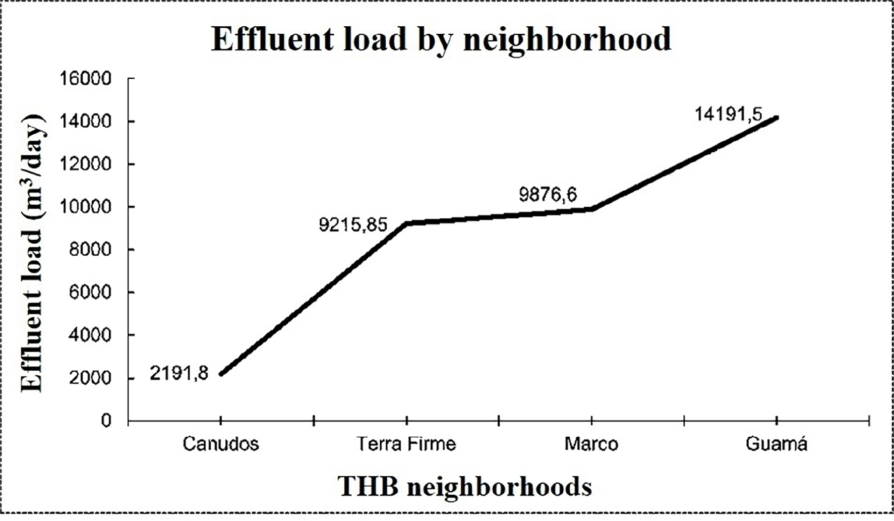
Due to the potential impact on water sources, identifying the neighborhoods that generate the most effluents is crucial for developing effective waste management strategies. Improper disposal is one of the leading causes of soil pollution, which can contaminate water tables and groundwater sources (GOUVEIA, 2012). By calculating sewage discharge per capita, it was possible to identify that the neighborhood of Guamá generates the most effluents per day, with a capacity to discharge 14,191.5 m3 of effluents. Interestingly, 37.5% of the residents interviewed in this neighborhood could not identify the type of sewerage system they had. 31.25% stated that it was a Drainage Network, 18.75% a Septic Tank, and 12.5% a Sewer Network. This lack of awareness about the type of sanitary service they have for collecting effluents is concerning, as it can contribute to environmental problems for the Tucunduba River without proper control or provision of sanitation services.
In a study conducted by Aguiar (2000) on the Tucunduba River, it was observed that the absence of sewage collection, particularly in the lower areas of the basin, contributes to environmental degradation. In these areas, blackwater flows into the Tucunduba stream through various sources, such as side ditches of the streets, canals, and the microdrainage network, ultimately compromising the water table. This contamination makes the water unsuitable for other uses and can promote the spread of waterborne diseases, including tinea versicolor, gastrointestinal diseases, cholera, worms, and hepatitis.
In the neighborhoods of Terra Firme and Marco, it is estimated that 9,216 m3/day and 9,877 m3/day of effluents are produced, respectively, requiring treatment or proper disposal (Figure 5).
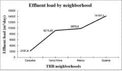
It is concerning, given that only 17.4% of residents reported having access to a Sewer Network. However, interviews with residents indicated that there is no predominant type of sewerage system in these neighborhoods. Specifically, 30.4% of Terra Firme residents reported using a Septic Tank, 26.1% reported using a Drainage Network, 21.7% were unable to answer, and 13% reported disposing of their effluents in the open. This lack of uniformity in the type of sewerage system used can lead to long-term environmental and public health problems in these river areas.
In the neighborhood of Canudos, 50% of participants reported using the Sewerage System for sewage disposal, while the other 50% stated that they did not know the type of sewerage system they had.
Studies have shown that in the year 2000, the primary diseases affecting the population living along the Tucunduba River were gastrointestinal diseases (46% of the population studied), schistosomiasis, and leptospirosis (23%). These data were obtained before implementing the Tucunduba Basin Integrated Sanitation Project (AGUIAR, 2000). However, Rebelo et al. (2018) research indicates that the same diseases continue to affect the population in similar proportions to those recorded before the project. The study also revealed that the habits of children bathing and using the Tucunduba River as a leisure area persist, which can contribute to the spread of these diseases.
The fact that Belém is ranked as the 4th worst city in terms of basic sanitation in the country is reflected in the population’s limited access to sewerage systems. With regards to sewage treatment, Belém has indicators that are below the national average, with only 2.82% of the sewage generated in the municipality being treated (INSTITUTO TRATA BRASIL, 2021). In addition, flooding is a major problem in Belém during the rainy season, which increases the risk of contamination for the population living in flooded areas. The World Health Organization (WHO) has emphasized that the lack of basic sanitation policies increases public health treatment expenses.
The National Sanitation Information System (SNIS) data indicates that approximately BRL 14 million were spent on treating waterborne diseases in the North region of Brazil in 2018 (SNIS, 2019). Additionally, it is worth noting that according to the Pan American Health Organization (BRASIL, 2004), cities with complete sewerage networks have better human development indices and fewer people requiring healthcare services.
CONCLUSION
The results show that urban expansion, combined with the lack of municipal environmental management, has contributed to the main environmental problems observed, such as the loss of vegetation cover, urban effluent discharge, and inadequate disposal of solid waste. These issues directly impact the quality of life of residents around the basin, especially in peripheral neighborhoods where essential services are neglected.
Effective watershed management requires an integrated approach involving the managing body and the local population. All users of these areas have the right to be informed and participate in the decision-making process of the public policies implemented in their territory. One tool to achieve this is the creation of river basin committees, which can manage water resources in an integrated way with public participation. Given that the municipality of Belém is divided into 14 river basins and currently lacks such committees, their establishment would be a critical step toward sustainable watershed management.
ACKNOWLEDGEMENTS
The authors would like to thank Coordenação de Aperfeiçoamento de Pessoal de Nível Superior (CAPES) for a scholarship. We are also grateful to Universidade Federal do Pará for technical support and infrastructure.
REFERENCES
- AGUIAR, S. A. Degradação socioambiental: um estudo sobre a população residente na proximidade da foz do igarapé Tucunduba (Belém - Pará). 2000. 45f. Monografia (Especialização em Educação Ambiental) - Núcleo de Meio Ambiente, Universidade Federal do Pará, Belém, 2000.
- ALMEIDA, L. Q. Vulnerabilidades socioambientais de rios urbanos : bacia hidrográfica do rio Maranguapinho, região metropolitana de Fortaleza, Ceará. 2010. 278f. Tese (Doutorado em Geografia, Área de Concentração em Organização do Espaço). Instituto de Geociências e Ciências Exatas, Universidade Estadual Paulista, Rio Claro, 2010.
- AMORIM, Samuel Maria de. Avaliação de indicadores de saúde ambiental em área urbana em uma situação de macrodrenagem, Belém-Pará. Cadernos Saúde Coletiva, v. 15, n. 4, p. 543-558, 2007.
- ARAÚJO, Lincoln Eloi de et al. Impactos Ambientais em Bacias Hidrográficas - Caso da Bacia do Rio Paraíba. Revista Tecnológica, v. 13, n. 2. p 109-115, 2009.
- BAUER, Martin W.; GASKELL, George. Pesquisa qualitativa com texto, imagem e som: um manual prático. Petrópolis: Editora Vozes, 2002. 516p.
- BRASIL. Ministério da Saúde. Organização Pan-Americana da Saúde. Avaliação de impacto na saúde das ações de saneamento: marco conceitual e estratégia metodológica. Organização Pan-Americana da Saúde. Brasília, DF, 2004. 116p.
- CHOI, Woonsup; DEAL, Brian M. Assessing hydrological impact of potential land use change through hydrological and land use change modeling for the Kishwaukee River basin (USA). Journal of Environmental Management, v. 88, n. 4, p. 1119-1130, 2008.
- CHRISTOFOLETTI, A. Geomorfologia. 23. ed. São Paulo: Edgard Blücher, 1980. 101p.
- COMPANHIA DE DESENVOLVIMENTO E ADMINISTRAÇÃO DA ÁREA METROPOLITANA DE BELÉM (CODEM). Bacias hidrográficas. Prefeitura Municipal de Belém. 2014. Available online from: Accessed at: 25 sep. 2022.
- CRUZ, Gilson Campos Ferreira. The urban area of the Verde River Basin and the environmental impacts caused by the urbanization of Ponta Grossa - PR - Brasil. Brazilian Journal of Development, v. 6, n. 11, p. 87916-87934, 2020.
- FARIAS, Ariadne; MENDONÇA, Francisco. The Urban Environmental System perspective on socio-environmental risks of urban flooding. Sociedade & Natureza, v. 34, e63717, 2022.
- FEDERAL INTERAGENCY STREAM RESTORATION WORKING GROUP (FISRWG). Stream corridor restoration: Principles, processes, and practices. United States Environmental Protection Agency. 1998. Available online from: . Accessed at 25 oct. 2023.
- FERREIRA, C. F. Produção do espaço urbano e degradação ambiental: um estudo de caso sobre a várzea do Igarapé do Tucunduba Belém-Pará. 1995. 120f. Dissertação (Mestrado em Geografia Física) Coordenadoria de Pós-Graduação em Geografia Física, Universidade de São Paulo, São Paulo, 1995.
- GORAYEB, A. Análise integrada da paisagem na bacia hidrográfica do rio Caeté - Amazônia Oriental - Brasil. 2008. 203f. Tese (Doutorado em Geografia) - Universidade Estadual Paulista, Programa de Pós-Graduação em Geografia, Rio Claro, 2008.
- GOUVEIA, Nelson. Resíduos sólidos urbanos: impactos socioambientais e perspectiva de manejo sustentável com inclusão social. Ciência & saúde coletiva, v. 17, p. 1503-1510, 2012.
-
INSTITUTO BRASILEIRO DE GEOGRAFIA E ESTATÍSTICA (IBGE). Censo Brasileiro de 2010. Sinopse do Censo Demográfico 2010. 2010. Available online from: < https://www.ibge.gov.br/censo2010/apps/sinopse/index.php?dados=21&uf=15>. Accessed at 13 nov. 2022.
» https://www.ibge.gov.br/censo2010/apps/sinopse/index.php?dados=21&uf=15 - INSTITUTO TRATA BRASIL. Região Norte do Brasil carece de investimentos em saneamento básico. Trata Brasil. 2021. Available online from: . Acessed at 10 may 2022.
- MARINHO, A. V. R.; SARAIVA, J. S.; RODRIGUES, J. E. C. Caracterização socioambiental da bacia urbana do Tucunduba, Belém-PA. Revista do Instituto Histórico e Geográfico do Pará, v. 2, n. 2, p. 96-107, 2015.
- MATOS, Fernando Cardoso et al. Análise temporal da expansão urbana no entorno do Igarapé Tucunduba, Belém, PA, Brasil. Revista Biociências, v. 17, n. 1, 2011.
- MAY, Tim. Pesquisa social: questões, métodos e processos. 3. ed. Porto Alegre: Artmed, 2004. 167p.
- MONTEIRO, Marcela Cunha; JIMÉNEZ, José Antonio; PEREIRA, Luci Cajueiro Carneiro. Natural and human controls of water quality of an Amazon estuary (Caeté-PA, Brazil). Ocean & coastal management, v. 124, p. 42-52, 2016.
- SISTEMA NACIONAL DE INFORMAÇÕES SOBRE SANEAMENTO BÁSICO (SNIS). Diagnóstico do manejo de Resíduos Sólidos Urbanos - 2018. Ministério da Integração e do Desenvolvimento Regional. 2018. Available online from: . Accessed at 06 jul. 2021.
- ORGANIZATION FOR ECONOMIC COOPERATION AND DEVELOPMENT ( OECD). Indicators to measure decoupling of environmental presures from economic growth. OECD Publications, Paris. 2002. Available online from: . Acessed at 10 sep. 2019.
- PELIZZOLI, M. L. A emergência do paradigma ecológico: Reflexões ético filosóficas para o séc. XXI. Petrópolis, Rio de Janeiro: Vozes, 1999. 160p.
- PORTO, Klayre Garcia; FERREIRA, Idelvone Mendes. Gestão das bacias hidrográficas urbanas e a importância dos ambientes ciliares. Geografia em Questão, v. 5, n. 2, 2012.
- REBÊLO, Marcos Vinicius da Silva et al. Avaliação do impacto sobre a saúde humana ocasionado por obras de macrodrenagem do Igarapé Tucunduba, Belém/PA/Impact assessment on human health from macrodrenage works of Igarapé Tucunduba, Belém/PA. Brazilian Applied Science Review, v. 2, n. 5, p. 1839-1847, 2018.
- RICHARDSON, Roberto Jarry. Pesquisa Social: métodos e técnicas. São Paulo: Atlas, 1999.
- RODRIGUES, P. R. S. Análise espacial de suscetibilidade à Inundação da Bacia Hidrográfica Do Tucunduba-Belém-Pa. 2019. 83f. Trabalho de Conclusão de Curso (Bacharelado em Engenharia Ambiental & Energias Renováveis) - Universidade Federal Rural da Amazônia, Belém, 2019.
- SALLES, Mario Henrique Dourador et al. Avaliação simplificada de impactos ambientais na bacia do Alto Sorocaba (SP). Revista de estudos ambientais, v. 10, n. 1, p. 6-20, 2008.
- SARDINHA, Diego de Souza; CONCEIÇÃO, Fabiano Tomazini da; GODOY, Letícia Hirata. Índice simplificado na avaliação de impacto ambiental nos recursos hídricos da bacia hidrográfica do Ribeirão do Meio, Leme, São Paulo, Brasil. Augmdomus, v. 2, p.82-97, 2010.
- SILVA, A. L. A. Uso da água na Bacia Urbana do Igarapé do Tucunduba- Belém-PA. 2016. 118f. Dissertação (Pós-Graduação em Geografia), Instituto de Filosofia e Ciências Humanas, Universidade Federal do Pará, Belém, 2016.
- SILVA, B. A. W.; AZEVEDO, M. M.; MATOS, J. S. Gestão Ambiental de Bacias Hidrográficas Urbanas. Revista Vera Cidade, v. 3, n. 5, 2006.
- SOUZA, Tania Machado Knaack de; OTTONI, Adacto Benedicto. Análise crítica das causas e soluções sustentáveis para o controle de enchentes urbanas: o caso prático da bacia hidrográfica da praça da bandeira (estudo de caso). Revista Nacional de Gerenciamento de Cidades, v. 3, n. 17, 2015.
- TARGA, Marcelo dos Santos et al. Urbanização e escoamento superficial na bacia hidrográfica do Igarapé Tucunduba, Belém, PA, Brasil. Revista Ambiente & Água, v. 7, p. 120-142, 2012.
- VON SPERLING, Marcos. Estudos e modelagem da qualidade da água de rios. DESA/UFMG, v. 7, 2007.
- YASSUDA, Eduardo Riomey. Gestão de recursos hídricos: fundamentos e aspectos institucionais. Revista de Administração pública, v. 27, n. 2, p. 5-18, 1993.
Edited by
-
Editors in Charge
Alexandra Maria OliveiraAlexandre Queiroz Pereira