
 Urbanity and Residential Land Prices: A State-of-the-Art Review
Abstract
Through a review of the state of the art, this research seeks to understand the relationships between socio-spatial attributes that confer urbanity and the price of urban residential land. The concept of urbanity, widely advocated in urban planning, is associated with specific forms of social interaction and spatial attributes. The research aims to identify which attributes impact preferences for residential location, specifying the most recurrent methods and statistical models in literature. Synthesizing the results found in the listed studies, a magnitude indicator is developed to access the impact of each attribute on prices, and the thematic summarization method is used. The conclusion reached is that urbanity is appreciated and positively impacts the real estate market, especially regarding accessibility to employment and consumption centres, as along with functional and social diversity. However, this appreciation may exclude portions of the population unable to pay for the advantages of these urbanity-rich locations.
Key-words:
urbanity; residential land prices; spatial configuration; urban form; land use
Resumo
Mediante revisão do estado da arte, busca-se compreender as relações entre atributos socioespaciais conferentes de urbanidade e o preço do solo residencial urbano. O conceito de urbanidade, amplamente defendido na teoria e no planejamento urbano, está associado a formas de interação social e atributos espaciais específicos. A pesquisa visa identificar quais atributos impactam as preferências pela localização residencial, especificando também métodos e modelos estatísticos mais recorrentes na literatura. Para a síntese dos resultados encontrados nos estudos elencados, é elaborado um indicador de magnitude do impacto de cada atributo sobre os preços e utilizado o método de sumarização temática. Conclui-se que a urbanidade é apreciada e impacta positivamente o mercado imobiliário, especialmente quanto à acessibilidade a centros de emprego e consumo, diversidade funcional e social. Tal apreciação, não obstante, pode excluir parcelas da população incapazes de pagar pelas vantagens dessas localizações ricas em urbanidade.
Palavras-chave:
urbanidade; preço do solo residencial; configuração espacial; forma urbana; uso do solo
1 Introduction
The notion of urbanity - understood as the manifestation of human interactions fostered by specific combinations of spatial attributes - has been widely developed both as a theoretical construct (Aguiar, 2012; Holanda, 2002; Marcus, 2010; Lees, 2010; Montgomery, 1998; Moraes Netto, 2017) and as a foundation for urban planning and design (Kashef, 2016; Martino et al., 2021; Yu et al., 2017). These spatial attributes are expected to influence the pricing of urban residential properties, shaping distinct submarkets according to preferences for particular spatial structures (Kang, 2018; Schirmer et al., 2014; Zhang et al., 2021). This article presents a state-of-the-art review, guided by the question “How do spatial attributes that enhance human interactions and confer urbanity relate to the unequal pricing of urban residential properties?” It examines which spatial attributes affect inequalities in residential prices, emphasizing those related to urbanity and identifying the methods and statistical models employed. The discussion proceeds by defining the socio-spatial dimensions associated with urbanity, outlining the methodological approach and synthesis strategy, and presenting the review results regarding the influence of urbanity-related attributes on property prices. Finally, it synthesizes how these variables operate across different socio-spatial contexts, highlighting their social implications and potential relevance for housing policy.
1.1 Socio-spatial attributes impacting urban property prices
1.1.1 Land and property prices and urban spatial structure
Neoclassical urban economics posits that land value decreases with distance from the city centre, following Alonso’s (1964) model, which associates centrality and accessibility with higher profitability and, consequently, higher land prices. Central areas typically exhibit greater accessibility, density, and land-use diversity - the components of spatial capital (Marcus, 2010, 2024; Marcus; Colding, 2014) and urbanity (Aguiar, 2012; Holanda, 2002, 2012; Krafta, 2014; Montgomery, 1998). Peripheral areas, in contrast, tend to display lower levels of these attributes and reduced exposure to negative externalities such as pollution and congestion (Neuman, 2005).
Yet neoclassical theory overlooks local particularities and neighbourhood externalities that influence prices (Grieson; White, 1989; Strange, 1992). In residential contexts, prices also reflect spatial and social factors such as built form, socioeconomic composition, and proximity to amenities or disamenities (Schirmer et al., 2014; Lee, 2016; Zhang et al., 2021; Paixão, 2015). While dense and diverse environments may attract certain social groups, their associated negative externalities can discourage others (Neuman, 2005).
Broadly, the literature distinguishes two classes of socio-spatial attributes affecting residential property prices: location and neighbourhood. The former relates to spatial configuration, whereas the latter includes urban form, functional diversity, and social diversity. Except for the latter, these factors are encapsulated by Marcus’s (2010) concept of spatial capital, from which urbanity emerges as the behavioural manifestation of human interactions enabled by this spatial potential.
The urban spatial structure plays a key role in defining differential land prices, thereby affecting real estate prices and conditioning the residential supply. However, neoclassical literature is partial in that it overlooks supply-side dynamics that actively seek to produce spatial differentiations as a strategy for enhancing the value of certain urban areas. In this sense, while spatial centrality fosters the concentration of specific services, market strategies reinforce this spatialization, with master plans, developers, and commercial capital acting in concert to produce urban synergies (Smolka, 1987). In other words, environments endowed with urban goods, services, and amenities that simultaneously attract a social demand profile capable of bearing the high cost of location, and that, in turn, reinforce that cost.
This process has intensified since the crisis of the Fordist mode of production, as real estate assets have increasingly become investment objects for surpluses generated in other economic sectors (Harvey, 2013). Given that these assets depreciate just in the long term, such investments are considered secure only when it is perceived that a given location will incorporate prestigious attributes unlikely to be threatened in the foreseeable future. Consequently, urban conventions are formed among the agents who produce space (Abramo, 2007a), crystallizing in certain areas or urban development corridors (Villaça, 2001) those attributes perceived as positive - and, likely, producers of urbanity - which define areas regarded as safe for investment while simultaneously excluding the majority unable to afford the high prices of land.
1.1.2 Urbanity
The city should be understood as a complex system whose behaviours emerge from the interactions among agents. Classical and contemporary studies (Batty, 2005; Bettencourt, 2013; Jacobs, 2011 [1961]; Portugali, 2016; Salingaros, 1998) emphasize that urban structure does not result from isolated components, but from interactive relationships that provide coherence and meaning to the system. The evolution of cities is incremental and adaptive, resembling living organisms endowed with properties of openness and emergence (Allen; Strathern, 2003). Jacobs (2011) anticipated this perspective by showing that the diversity of agents and activities creates a complex order sustained by everyday human interactions, from which local resilience arises. Diverse neighbourhoods tend to adapt more effectively to demographic and economic transformations, whereas homogeneous ones prove more fragile (Gospodini, 2006; Montgomery, 1998).
Complexity Theory deepens this understanding by introducing the concepts of self-organization, emergence, and systemic learning (Gunderson; Holling, 2001; Lim; Kain, 2016; Scheurer, 2007; Page, 2011). Interactions among urban micro-agents promote adaptive processes that enhance innovation and social productivity (Marcus, 2015; Arbesman et al., 2009). Urban networks of public spaces structure the flows of information, energy, and matter, influencing the evolution and resilience of the system (Salingaros, 1998; Marcus; Colding, 2014). Urban resilience, in turn, is grounded on four interdependent attributes - diversity, density, accessibility, and learning (Marcus; Colding, 2014) - whose balance enables adaptive capacity and the emergence of urbanity.
Urbanity, therefore, may be defined as the degree and manner in which individuals interact within urban space (Aguiar, 2012; Krafta, 2014), with these interactions underpinning the positive outcomes linked to productivity, innovation, and resilience. Urbanity depends directly on urban form, and Marcus (2010, 2024) associates it with the convergence of three morphological dimensions - accessibility, differentiation of forms, and density - that together define what he terms spatial capital. This concept seeks to explain how urban form generates opportunities for interaction while also translating into economic value (Marcus, 2010; Marcus et al., 2019). Accordingly, locations richer in spatial capital and urbanity tend to concentrate interactions and attract economic functions that benefit from them, rendering land more competitive and expensive. At the same time, they foster social and cultural development by offering accessibility to social differences - that is, encounters among people with diverse backgrounds. Thus, the theory of spatial capital provides an analytical starting point for classifying urbanity and understanding its effects on property prices and urban socioeconomic dynamics.
However, Marcus’s (2010, 2024) theory of spatial capital is based on a deterministic assumption of the influence of urban form on the potential for interaction, disregarding that in many contexts - particularly within the changing realities of Global South cities - certain fixed combinations of forms may accommodate highly diverse social contents. In other words, where (form) matters, but who interacts (social aspects) and what is performed (functional aspects) are also crucial to the quality of the exchanges that sustain urbanity (Aguiar, 2012; Holanda, 2002, 2012; Lees, 2010).
Building upon the previous discussion, urbanity can be more precisely defined as the emergent quality of urban environments that sustain intense, diverse, and reciprocal human interactions. The concept has a long intellectual lineage, from Simmel’s (2014[1903]) reflections on metropolitan sociability and Lefebvre’s (2002[1970]) notion of the urban as a social production of space, to Jacobs’s (2011) idea of the city as a generator of organized complexity. In contemporary urban morphology, urbanity is understood as a relational property of urban form - an expression of how spatial configuration, land-use diversity, and social heterogeneity interact to enable encounters and exchanges (Marcus, 2010, 2024; Krafta, 2014; Holanda, 2002, 2012). Following this perspective, urbanity is not reducible to physical form alone; rather, it emerges from the interdependence among three analytical levels - spatial patterns, spatial life, and social life (Holanda, 2002) - which together determine the intensity and quality of urban interactions. High levels of urbanity indicate environments where spatial accessibility, functional differentiation, and social diversity converge, fostering innovation, resilience, and social learning. Thus, urbanity operates simultaneously as a spatial condition, a social process, and an urban outcome, bridging the physical and socio-economic dimensions of the city.
In synthesizing spatial attributes that differentially impact urban property prices, the relationships between urbanity and this economic variable can manifest in multiple ways, although some recent studies have suggested positive social appreciation of the phenomenon (Barreca et al., 2020a, 2020b; Nadai; Lepri, 2018). Thus, a brief consideration is pertinent on how both classes of socio-spatial attributes relate to residential property pricing. Furthermore, upon confirming the social valuation of urbanity, with positive impacts on prices, it is important to consider the detrimental repercussions on groups that cannot sustain the costs of such favourable locations, effects that transcend mere accessibility inconveniences - commuting cost and time (Coelho et al., 2022; Dattwyler et al., 2019).
1.1.3 Location attributes
Urban spatial configuration plays a crucial role in shaping property prices, primarily synthesized by two key indicators: accessibility and centrality. Accessibility refers to the ease of reaching various urban destinations (Hansen, 1959), while centrality measures the importance of a street or segment within the broader system of spatial connections (Krafta, 1994). Both indicate locational advantage, which attracts tertiary activities reliant on visibility and higher profitability per land unit (Alonso, 1964). Consequently, this dynamic elevates land prices and intensifies urban land use (Porta et al., 2009).
Furthermore, proximity to amenities, facilities, employment centres, and consumption hubs significantly influences residential location choices, contributing to land appreciation. People often prefer living near workplaces (Zolfaghari et al., 2012), areas fulfilling daily needs (Barreca et al., 2020b; Schirmer et al., 2014), or natural amenities (Kang, 2019; Law, 2017). Such privileged locations tend to become denser and more diverse, increasing property prices - although, in some cases, the associated negative externalities may discourage certain buyers, partially offsetting price gains.
1.1.4 Neighbourhood attributes
The neighbourhood context of a property can be defined through attributes of urban form (density and morphological diversity), functional diversity, and social diversity. Density can be measured either as the ratio between the number of people living, working, or consuming in a space and its area (Clark; Moir, 2015), or as the built surface per unit of land (Pont; Haupt, 2021). Functional diversity, according to UN-Habitat (2015), refers to the coexistence of various compatible land uses within a given area. Higher density increases the flow of people through limited space, reinforcing the concentration of activities that benefit from this movement and generate additional interaction potential.
Although high density and functional diversity typically indicate competitive and expensive locations - bringing people closer to workplaces and services and fostering vibrant environments - their effects on residential prices are not always positive (Kang, 2018; Lee, 2016). Preferences for these characteristics can differ considerably among social groups (Zhang et al., 2021) or between residents of apartments and single-family homes (Guo et al., 2016).
Social diversity, in turn, refers to the presence of people from different socioeconomic, ethnic, gender, and age groups sharing the same urban space (Martino et al., 2021). Such coexistence fosters human skills like negotiation, tolerance, and civility - key aspects of urbanity (Aguiar, 2012; Holanda, 2012) - and can also enhance employment and personal development opportunities for vulnerable populations (Gomes-Ribeiro; Queiroz-Ribeiro, 2021). Nonetheless, the relationship between social diversity and property prices varies widely: in Latin America and Canada, socially mixed areas often face devaluation (Marmolejo-Duarte; Souza, 2011; Grant; Perrot, 2009), whereas in Japan, such diversity tends to be more positively regarded (Lim; Kain, 2016).
2 Materials and Methods
The review covered the period from January 2014 to December 2023 to encompass the most recent discussions on the topic. No restrictions regarding theoretical frameworks were applied; however, only studies published in Spanish, English, and Portuguese in peer-reviewed journal articles, books, or conference proceedings were considered. An aggregative strategy was adopted, in which the results of primary studies are aggregated to obtain the review's results. This approach seeks to connect two or more aspects of a phenomenon without concern for the objectives, motivations, or methodologies of the primary studies that produced the results (Morandi; Camargo, 2014).
The main question driving the review, outlined in the Introduction, was unfolded into two specific questions:
-
How does the variation in configurational, formal, functional, and socioeconomic attributes relate to the variation in urban residential property prices?
-
How does urbanity relate to the differentiation of urban residential property prices?
These specifications were useful for capturing both studies concerned with the general issue of how different attributes impact prices (often considered in isolation or limited groupings) and the specific question of how urbanity is valued (or devalued) within the real estate market1. It is noteworthy that out of the 36 studies selected in the third stage of the review, only three explicitly mention the impacts of urbanity on land prices. Given the high significance of their results, this indicates a limited development of the topic in the literature.
For the selection of studies that address the two questions, the attributes potentially impacting residential land prices were grouped into five categories, associated with the search terms listed in Table 1. The category "Residential land price" corresponds to the dependent variable, while "Spatial centrality,"2 "Urban Form," "Land uses/Functional diversity," "Socioeconomics/Social diversity," and "Urbanity" represent the spatial attributes or explanatory variables. It should be noted that the search terms were restricted to the title, abstract, and keywords of the studies. Finally, the survey was limited to the databases Web of Science, Scopus, and Scielo.
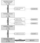
The study selection involved three stages. The first resulted in an inventory of all works that met the specifications of the search protocol. A total of 623 were identified through Scopus, 488 with Web of Science, and six using Scielo. With the assistance of the reference manager Zotero, version 6.0.30, studies found in more than one database were aggregated, and duplicates were removed. Thus, a total of 889 publications were identified at the end. During the first stage, the titles and abstracts of the studies were read, and those not related to the review questions were excluded. Ultimately, 164 studies were included for the second stage.
The second stage of selection involved a re-reading of the abstract and a superficial reading of the other sections of the study, with an emphasis on the methods employed. At this stage, another forty studies were excluded for various reasons such as unavailability of the full text, excessively specific or broad objectives, or objectives not aligned with the review's aim. From the remaining 124 publications, those whose scope was limited to a small number of explanatory attributes of price variation, neglecting other locational or spatial attributes, were also excluded. To achieve this, we employed an elimination technique, i.e., the 23 explanatory attributes listed in the 124 studies and directly related to the guiding questions of the review were grouped into six classes3, as shown in Table 2. Studies that did not cover at least four classes or five attributes (distributed across at least three classes) were excluded. This measure was justified in view of the objective of this article, which is oriented around attributes that manifest themselves in combination, in order to confer urbanity to the surroundings.
The mentioned eliminatory process resulted in the exclusion of another 85 studies, leaving 39 for the third stage of selection. In this stage, after a thorough reading of the full publications, three more studies were eliminated due to discrepancies with the review's objectives. Consequently, the results from 36 studies originating from fourteen countries across four continents, encompassing both developed and developing nations, were analysed. This enables a global unveiling of the relationships between prices and socio-spatial attributes. The analysis will be conducted using the thematic summarization method, which aims to quantify the results in a straightforward manner by compiling the significant conclusions of the studies to address the review's questions. Prior to this, Figure 1 illustrates the methodological steps outlined above.
For each study, positive (+), negative (-), neutral (+/-), or zero (0) signs were assigned according to the direct, inverse, ambivalent, or non-significant statistical relationships found between residential property prices and each explanatory attribute, in that order. Then, an indicator of the magnitude of the importance of each socio-spatial attribute on property prices was devised. With this aim in mind, the signs found in the studies (+1, 0, or -1) for each attribute were summed. The result of the sum was then divided by the number of occurrences of the attribute in the universe of studies and multiplied by 100, resulting in a percentage value reflecting the degree of relationship (direct or inverse) between property prices and the attribute according to the results of each study and their frequencies. This percentage was subsequently multiplied by the ratio of the number of occurrences of the attribute to the sum of the occurrences of all attributes, so that the result (magnitude) reflected the importance of the attribute within the universe of studies. Equations 1, 2, and 3 summarize the calculation described:
In which,
Then,
M indicates the importance magnitude of the attribute; n is the number of occurrences of the attribute in the universe of studies; F corresponds to the sum of the occurrences of all attributes; r indicates the degree of relationship between property prices and the attribute according to the results of each study and their frequencies; and s is the sum of the signs, for the respective attribute, found in the studies.
3 Results of the state-of-the-art review
3.1 Employed methods and models
Regarding geographic distribution, among the 36 studies identified, thirteen (36.1%) refer to the Global South, but only one to the Latin American context (Morales et al., 2020).
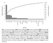
Almost the totality of studies, 35 (97.2%), explore the relationship between spatial attributes and land price using Hedonic Price Models (HPMs), a technique that investigates the value that each attribute or group of attributes holds for consumers interested in purchasing a certain commodity. This commodity is characterized as heterogeneous, i.e., a collection of characteristics, the prices of which sum up to the final price of the commodity (Xiao, 2016). HPMs are anchored in various econometric models, ranging from traditional Ordinary Least Squares (OLS) to more complex specifications, such as X-Gradient Boosting Decision Trees (XGBDT) (Chen et al., 2023) or Random Forest (Zhang et al., 2021). Additionally, while OLS is predominant, a significant proportion of studies incorporate the dimension of spatial and/or temporal dependence, utilizing modelling techniques such as Spatial Lag Model (SLM) (Seo et al., 2014, and others); Spatial Error Model (SEM) (Kasraian et al., 2023, and others); Geographically Weighted Regression (GWR) (Wang; Chen, 2020, and others); Spatial Autoregressive Model (SAR) (Vinci et al., 2022, and others); Difference in Differences (DiD) (He, 2020, and others); and so on. Lastly, a few studies focus on the nonlinear or stratified behaviour of relationships, adopting functional specifications such as Quantile Regression (QR) (Lee, 2016, and others).
Figure 2 displays the volume of studies by employed method, noting that most studies utilized more than one technique, typically comparing their effectiveness. It is evident that OLS predominates, present in 26 studies (72.2%), followed by the spatial models SLM and SEM, each appearing in eight studies (22.2%), and by GWR, in seven publications (19.4%). QR, DiD, and SAR appear in only three studies each (8.3%), while more modern models such as the Spatial Durbin Model (SDM) and Multilevel Hedonic Price Model (MLM) are present in only two publications each (5.6%). The remaining methods appear only once (2.8%).
3.2 The impact of attributes contributing to urbanity on residential land prices
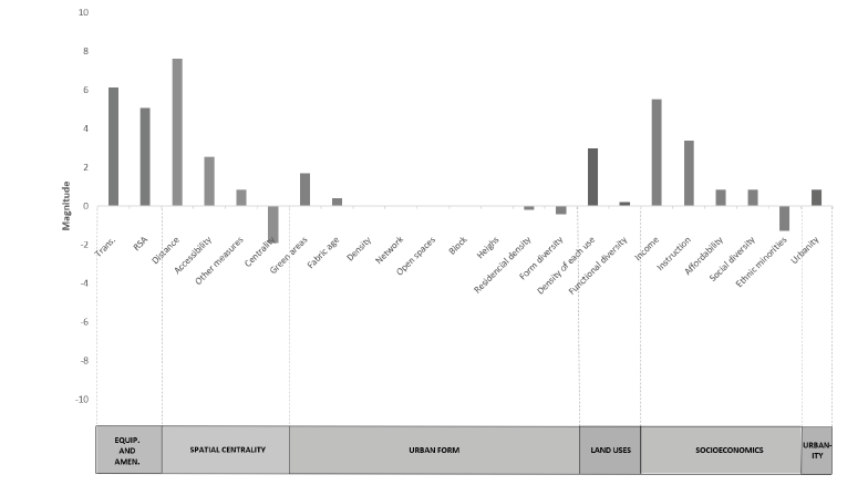
In Figure 3 and Table 3, the importance magnitude of each attribute is displayed, considering the direction of the relationship (direct or inverse), weighted by the frequency of significant occurrences and the frequency of the attribute in the universe of selected studies.
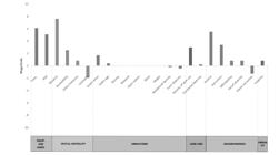
Magnitudes of the relationships between explanatory locational attributes and residential land prices from the studies included in the analysis. RSA: access to retail, services and amenities.
3.2.1 Location attributes
The most significant class of attributes influencing residential land prices is Access to equipment and amenities. Accessibility to “Transport” infrastructure shows the second-highest magnitude (positive, 6.14), indicating that proximity to subway systems - and, to a lesser extent, to train and bus stops - is generally valued. For subways, the appreciation effect is consistently observed across diverse contexts, such as Toronto (Zhang et al., 2021), Tehran (Soltani et al., 2021), Kolkata (Chakrabarti et al., 2022), Seoul (Kang, 2018; Lee, 2016), South Korean metropolitan regions (Ahn et al., 2020), Wuhan (Li; Huang, 2020; Tan et al., 2019), Shanghai (Guan; Peiser, 2018; Wang et al., 2016), and Hong Kong (He, 2020).
Proximity to bus stops, however, may heighten noise and discomfort, generating mixed findings: positive effects in Toronto and Salt Lake City (Tian et al., 2017; Zhang et al., 2021), but negative in Xiamen (Yang et al., 2020). Conversely, Bus Rapid Transit (BRT) systems tend to raise prices in Brisbane (Mulley et al., 2017) and Auckland (Filippova; Sheng, 2020). Light Rail Transit (LRT) also produces appreciation in London’s Docklands (Song et al., 2019) and Phoenix (Seo et al., 2014). Importantly, in Beijing (Duan et al., 2021) and Austin (Chen et al, 2023), the relationship between price and public transport access varies by social group: poorer households dependent on transit value such proximity, whereas wealthier groups - more reliant on private mobility - may devalue it. In Austin, areas predominantly inhabited by minority ethnic groups experience higher prices when near public transportation stations/stops, in contrast to predominantly white areas.
“Retail, service, and amenities” availability is also strongly appreciated (magnitude 5.08). The possibility of meeting daily needs “at the doorstep” - including access to green and outdoor spaces - positively affects prices in a wide range of contexts: Columbus (Wang; Chen, 2020), London (Law, 2017; Song et al., 2019), Oslo (Heyman; Sommervoll, 2019), major Italian cities (Nadai; Lepri, 2019), Greek cities (Vinci et al., 2022), Khulna (Rahman et al., 2021), Kolkata (Chakrabarti et al., 2021), Seoul (Kang, 2018), Beijing (Duan et al., 2021; Li et al., 2017), Wuhan (Li; Huang, 2020), Xiamen (Yang et al., 2020), the Pearl River Delta (Wang et al., 2022), Hong Kong (He, 2020), and Shanghai (Guan; Peiser, 2020; Wang et al., 2016).
Nevertheless, differential responses appear between dwelling types: in Adelaide and Wuhan, Guo et al. (2016) and Li and Huang (2016) found that single-family house residents are more sensitive to negative externalities in dense commercial areas, leading to depreciation, whereas apartment dwellers tend to value such environments.
Although parks and water bodies are typically appreciated, exceptions arise in Phoenix (Seo et al., 2014), Tehran (Soltani et al., 2021), South Korean metropolitan areas (except near coastlines) (Ahn et al., 2020), and Kolkata (Chakrabarti et al., 2022). These results are generally attributed to crowding, emergence of undesirable activities, insecurity, or deficient maintenance.
The second most relevant class is Spatial Centrality. Distance to employment centres emerges as the strongest single determinant of residential prices (magnitude 7.63), revealing a consistent preference for central or employment-proximate locations (Ahn et al., 2020; Chen et al., 2023; Duan et al., 2021; Guan; Peiser, 2018; Filippova; Sheng, 2020; Guo et al., 2016; Hawkins; Habib, 2018; Kang, 2018, 2019; Kasraian et al., 2023; Morales et al., 2020; Mulley et al., 2017; Li et al., 2019; Seo et al., 2014; Rahman et al., 2021; Song et al., 2019; Tan et al., 2019; Vinci et al., 2022; Wang et al., 2016; Yang et al., 2020; Zhang et al., 2021). Only in Columbus (Wang; Chen, 2020) and Tehran (Soltani et al., 2021) does distance from the CBD correlate with higher prices, reflecting preferences for suburban lifestyles.
“Accessibility,” indicating geometric proximity or spatial advantage, is also positively related to prices in nearly all studies where it appears (Chakrabarti et al., 2022; He, 2020; Kang, 2018; Law, 2017; Morales et al., 2020; Tian et al., 2017), with the sole exception of Wuhan (Tan et al., 2019). Its lower magnitude (2.54) reflects its relatively limited use in the reviewed literature compared to linear distance measures.
“Centrality,” understood not only as proximity to key arterial roads and broader urban-regional connections but also to the negative externalities they produce, exhibits an overall negative magnitude (-1.91). Positive price-centrality relationships were found only in less developed socio-spatial contexts where large non-motorized populations rely on immediate proximity to clustered commercial and service activities, such as Guatemala City (Morales et al., 2020) and Khulna (Rahman et al., 2021). In most other contexts - London, Oslo, Seoul, and others - the association is negative (Filippova; Sheng, 2019; Heyman; Sommervoll, 2019; Kang, 2018; Song et al., 2019; Tan et al., 2019; Wang; Chen, 2020).
3.2.2 Neighbourhood attributes
Among the neighbourhood attributes, the class with the greatest impact on prices is Socioeconomics/Social Diversity. The "Income” of the surrounding area is, after distance and transport, the most relevant factor (magnitude of 5.51), a fact evident considering that poorer neighbourhoods tend to have cheaper properties. In no case was an opposite relationship found (Duan et al., 2021; Guo et al., 2016; Hanka et al., 2014; Hawkins; Habib, 2018; He, 2020; Kasraian et al., 2023; Morales et al., 2020; Seo et al., 2014; Rahman et al., 2021; Vinci et al., 2022; Wang; Chen, 2020; Wang et al., 2022; Zhang et al., 2021). The same direction is shown by "Instruction" (magnitude of 3.39), meaning that more educated neighbours imply more expensive residences (Ahn et al., 2020; Mulley et al., 2017; Filippova; Sheng, 2020; Song et al., 2019; Tian et al., 2017; Wang; Chen, 2020; Wang et al., 2022; Zhang et al., 2021).
Predominantly analysed in US-based research, a high proportion of "Ethnic minorities", not surprisingly, impedes residential appreciation (magnitude of -1.27) in Austin (Chen et al., 2023), Columbus (Wang; Chen, 2020), Louisville (Hanka et al., 2014), and Salt Lake City (Tian et al., 2017). In this case, the only possible exception may be Southern California, where Hipp and Singh (2014) comment on a recent increase in tolerance towards these groups. "Social diversity" and "Affordability," finally, although not appearing frequently, are attributes valued in virtually all occurrences (both variables with a magnitude of 0.85) (Hipp; Singh, 2019; and Zhang et al., 2021, for social diversity, and Wang; Chen, 2020; and Zhang et al., 2021, for affordability). The magnitude of the latter indicator may suggest non-linear income growth in relation to prices, i.e., the higher the household income, the greater the property's affordability (lower prices relative to income), a fact that would disproportionately burden the housing budget of poorer families.
Land Uses/Functional Diversity class shows positive results in most studies. "Density of each land use" has a magnitude of 2.97, generally demonstrating the high value placed on areas that concentrate certain uses (almost always commercial). This phenomenon holds true in Toronto (Hawkins; Habib, 2018; Kasraian et al., 2022), in the largest Italian cities (Nadai; Lepri, 2019), in Seoul (Kang, 2019), in Beijing (Li; Chen; Zhao, 2019), in Wuhan (Li; Huang, 2020), and in Xiamen (Yang et al., 2020). Conversely, in Columbus, the disproportion of land uses, with a predominance of either commercial or residential functions, tends to devalue residential properties (Wang; Chen, 2020). In Khulna, the concentration of retail areas depreciates properties, whereas the presence of agricultural areas has the opposite effect (Rahman et al., 2020).
"Functional diversity," although with a positive magnitude (0.21) and thus frequently in direct relation to prices, exhibits a more complex behaviour. It is generally perceived as an asset in Tehran (Soltani et al., 2021), Seoul (Lee, 2016), and Wuhan (Li; Huang, 2020). In Toronto, however, Zhang et al. (2021) point out that distinct income groups perceive this attribute differently: wealthier households value homogeneous surroundings, while poorer households prefer functionally diverse areas, presumably for the convenience of access to goods and services. In Adelaide, Guo et al. (2016) explain that a similar differentiation arises from typological choices: house dwellers primarily focus on the social and environmental costs of the neighbourhood, seeking socially homogeneous and environmentally pleasant locations. Conversely, apartment dwellers appreciate greater access to various activities nearby. Differently, in some very dense Asian cities like Seoul (Jang; Kang, 2015; Kang, 2018) and the Pearl River Delta (Wang et al., 2022), diversity seems to deter potential buyers, leading to property devaluation.
Lastly, it is concluded that Urban form is the least impactful class on prices, and the analysis of its attributes' behaviour requires caution. With a magnitude of 1.69, the presence of "Green areas" is generally appreciated (Seo et al., 2014; Tan et al., 2019; Tian et al., 2017; Wang et al., 2016). The "Average fabric age," in turn, shows a single positive result in Southern California, possibly associated with the “vintage effect” of certain historic locations (Hipp; Singh, 2014). Regarding this attribute, no negative correlations with prices were found, although three studies yielded non-significant results (Guan; Peiser, 2018; Lee, 2016; Nadai; Lepri, 2019), making its magnitude positive (0.42), but of questionable generality.
On the other hand, "Diversity of built forms" (magnitude of -0.42) (Hipp; Singh, 2014, for Southern California) and “Residential Density" (magnitude of -0.21) are elements generally undervalued. However, the second attribute shows a negative sign in only one study (Kang, 2018, for Seoul), is not significant in two others (Guan; Peiser, 2018; Li; Huang, 2020), and presents a weakly positive sign in the study on Austin (Chen et al., 2023). Regarding the two cities mentioned, the causes of the divergent relationships are diametrically opposed and worth noting: the high density of the South Korean capital, sometimes producing a sense of crowding, makes less dense residential neighbourhoods preferred (Kang, 2018). Conversely, in Austin - a notably low-density city - higher residential densities are valued over other land uses, although not higher densities overall (except in lower-income neighbourhoods) (Chen et al., 2023).
Other formal attributes such as built or populational “Density," "Network", "Open spaces," "Block size/shape," and "Building height” were not relevant in explaining residential property prices (magnitude zero). For "Density" and "Building height," this is due to the significant variation in the direction of the relationships. In the first case, prices tend to be higher in proportion to density in Southern California (Hipp; Singh, 2014), Toronto (Hawkins; Habib, 2018; Kasraian et al., 2023), major Italian cities (Nadai; Lepri, 2019), Greek cities (Vinci et al., 2022), Adelaide (Guo et al., 2016), the largest South Korean cities (Ahn et al., 2020), and Shanghai (Guan; Peiser, 2018). Conversely, density appears to devalue residential properties in Phoenix (Seo et al., 2014), Tehran (Soltani et al., 2021), Seoul (Jang; Kang, 2015; Kang, 2018; Lee, 2016), Hong Kong (He, 2020), and Auckland (Filippova; Sheng, 2020). In the second situation, while taller buildings seem to spatially coincide with more valuable properties in Seoul (Lee, 2016), the opposite is observed in the Pearl River Delta (Wang et al., 2022). The explanatory power of the form/density attributes of the "Network," "Open Spaces," and "Block size/shape" was ultimately deemed irrelevant in all studies.
It is noteworthy that there does not seem to be an automatic association between certain sociocultural configurations and density. The examined studies reveal that, on one hand, in urban organizations as diverse as those in Canada (Toronto), China (Shanghai), Greece, Italy, South Korea, and Australia (Adelaide), higher urban densities appear to be appreciated, at least by certain social groups. On the other hand, in equally diverse urban organizations such as those in the United States (Phoenix), Iran, South Korea (Seoul), China (Beijing, Wuhan, and Hong Kong), and New Zealand (Auckland), there is a suggested aversion to more densely built environments.
3.3 The impact of urbanity on residential land prices
Incorporating, to some extent, the other attributes (generally of positive magnitude), it is not surprising that the Urbanity class/attribute relates positively to prices in the three studies that considered it, expressing a magnitude of 1.279. Although not constructing a specific indicator, Nadai and Negri (2019) measure various neighbourhood attributes, based on Jacobs' theorization (Jacobs, 2011), and correlate it with land prices using the machine learning technique 'Gradient Boosted Trees'. They conclude that environments rich in urbanity are appreciated in the eight largest Italian cities. In the areas where the component attributes of this quality are present in greater intensity, prices are higher.
In Italy as well, Barreca, Curto, and Rolando (2020b) reveal a correlation between urbanity and pre-owned residential property prices in Turin, although spatial variations related to the social content of the area are evident. For example, socially vulnerable neighbourhoods, even if vibrant, contain poorly valued properties due to other factors such as stigmatization, low accessibility, violence etc. Regarding new or completely renovated properties, a correlation of the same nature is verified (Barreca et al., 2020a). Furthermore, areas with a higher concentration of retail and restaurants coincide with those with greater activity in the residential development industry because such locations are more desired by solvent demand.
Finally, in Scandinavia, Marcus et al. (2019) do not explicitly employ the notion of urbanity, but they reveal that urban areas richer in spatial capital exhibit higher residential property prices (in Norway) or higher land taxes (in Sweden), indicating that the formal dimensions conducive to urbanity are also valued as a residential asset in these countries. It should be noted that this study deals with general land price/value rather than residential properties. However, residential properties may become more expensive due to increased land competition resulting from heightened demand in these areas.
4 Final remarks
Among the studies examining the influence of socio-spatial attributes related to urbanity on residential prices, almost all relied on traditional hedonic models (97.2%), predominantly using non-spatial linear regressions (OLS, 72.2%), while spatial models such as SLM, SEM, and GWR appeared in roughly one-fifth of the cases. Only a minor share adopted alternative spatial or longitudinal approaches.
Regarding explanatory factors, the access to services and urban amenities are generally associated to increased residential prices, whereas centrality tended to reduce them. Urban form attributes such as a higher proportion of green areas and an older urban fabric were associated with appreciation, while residential density and built-form diversity indicated depreciation. Other morphological variables - including population or building density, block geometry, and building height - exhibited weak or heterogeneous effects. Functional attributes, such as land-use density and functional diversity, and socioeconomic characteristics like income, education, affordability, and social diversity tended to raise prices, whereas a higher proportion of racial minorities negatively affected them.
Although few studies explicitly addressed urbanity or spatial capital, all identified a positive relationship between these dimensions and land prices or land-related taxes, a pattern consistent across Mediterranean and Scandinavian contexts. Broadly, evidence suggests that the presence of attributes constitutive of urbanity is positively related to residential prices.
Urbanity, understood as the behavioural expression of spatial capital - a morphological synthesis of accessibility, density, and functional and social diversity - is generally appreciated and reflected in higher residential values. As defined by Aguiar (2012), Holanda (2002; 2012), and Krafta (2014), such configurations foster virtuous interactions among diverse individuals, promote well-being, and stimulate opportunities, creativity, and innovation (Bettencourt, 2013b; Marcus, 2015; Arbesman et al., 2009), while also enabling environments rich in redundancy and social learning (Marcus; Colding, 2014).
The literature reviewed therefore indicates that socio-spatial attributes associated with urbanity are valued by the residential market and contribute to price increases. Nonetheless, it is important to recognize that supply-side agents - public authorities, developers, and investors - are not passive responders to demand. Rather, they actively mobilize such preferences, creating market signals that reinforce conventions around areas well-endowed with services and amenities (or urbanity), thereby promoting synergies that sustain long-term valorisation and ensure capital circulation (Smolka, 1987; Abramo, 2007a).
Consequently, the desirability and competitiveness of these spaces generate exclusionary dynamics affecting social groups unable to afford them, who are thus deprived of the virtuous externalities of interaction. As Aguiar (2012) notes, urbanity stands in contrast with socio-spatial segregation. Although only the study by Morales et al. (2020) was conducted in a Latin American metropolis, in this regional context these groups are particularly sensitive to exclusion from urbanity. Abramo (2007b) and Gobatto et al. (2016) show that social housing complexes or informal settlements in Brazil tend to be located in segregated areas (i.e., with low global accessibility), as a result of market dynamics that raise land prices to unsustainable levels in more integrated surroundings. Their exclusion is further intensified by the under-provision of urban services and amenities, which, in the specifically Brazilian case, is aggravated by the prohibition of commercial activities within social housing estates. For this reason, and supported by the conclusions of Gobatto et al. (2016), it can be argued that low-income groups attempt to mitigate their accessibility deficits by informally or semi-formally creating a form of proto-urbanity at the margins of official planning. A clear example is the commercially vibrant favelas. Similarly, in many social housing estates, the proliferation of shops, bars, and food stalls occupying ground floors and parking areas illustrates how residents generate local amenities in response to formal urban voids.
This reinforces the need for inclusive housing policies - through direct provision or subsidies - capable of countering peripheralization and segregated residential allocation for lower-income groups (Coelho et al., 2022; Dattwyler et al., 2019). By accessing the benefits of urbanity, these groups would avoid the vicious cycle in which exclusion limits opportunities for employability and personal growth (Gomes-Ribeiro; Queiroz-Ribeiro, 2021), undermining the formation of human capital, fundamentally based on sharing and innovation (Marcus, 2015; Arbesman et al., 2009).
Acknowledgments
The authors thank the Coordination for the Improvement of Higher Education Personnel (CAPES) for the doctoral sandwich scholarship at Chalmers University of Technology granted during the preparation of this article.
References
- ABRAMO, P. A cidade caleidoscópica: coordenação espacial e convenção urbana. São Paulo: Bertrand Brasil, 2007a.
- ABRAMO, P. A cidade com-fusa: a mão inoxidável do mercado e a produção da estrutura urbana nas grandes metrópoles latino-americanas. Revista Brasileira de Estudos Urbanos e Regionais, Natal, v. 9, n. 2.
- AGUIAR, D. Urbanidade e a qualidade da cidade. In: AGUIAR, D.; NETTO, V. M. (orgs.). Urbanidades. Rio de Janeiro: Folio Digital: Letra e Imagem, 2012, p. 61-79.
-
AHN, K; JANG, H.; SONG, Y. Economic impacts of being close to subway networks: A case study of Korean metropolitan areas. Research in Transportation Economics, Amsterdam, v. 83, p. 1-7, nov. 2020. Disponível em: https://www.sciencedirect.com/science/article/abs/pii/S0739885920300986 Acesso em: 01 set. 2023.
» https://www.sciencedirect.com/science/article/abs/pii/S0739885920300986 - ALLEN, P. M.; STRATHERN, M. Evolution, Emergence, and Learning in Complex Systems. Emergence: complexity and organization [s.l.], v. 5, p. 9-33, 2003.
- ALONSO, W. Location and Land Use: toward a general theory of land rent. Cambridge: Harvard University Press, 1964.
- ARBESMAN, S., KLEINBERG, J. M., STROGATZ, S. H. Superlinear scaling for innovation in cities. Physical Review E, College Park, v. 79, p. 1-5, 2009.
-
BARRECA, A.; CURTO, R.; ROLANDO, D. Is the Real Estate Market of New Housing Stock Influenced by Urban Vibrancy? Complexity, Hoboken, v. 2020, p. 1-22, 2020a. Disponível em: https://www.hindawi.com/journals/complexity/2020/1908698/. Acesso em: 01 set. 2023.
» https://www.hindawi.com/journals/complexity/2020/1908698 - BARRECA, A.; CURTO, R.; ROLANDO, D. Urban vibrancy: an emerging factor that spatially influences the real estate market. Sustainability, Basel, v. 12, n. 1, p. 346-379, 2020b.
- BATTY, M. Cities and Complexity: Understanding Cities with Cellular Automata, Agent-Based Models, and Fractals. Cambridge: MIT Press, 2005.
- BETTENCOURT, L. M. A. The kind of problem a city is: New perspectives on the nature of cities from complex systems theory. Santa Fe: Santa Fe Institute, 2013.
-
CHAKRABARTI, S.; KUSHARI, T.; MAZUMDER, T. Does transportation network centrality determine housing price? Journal of Transport Geography, Amsterdam, v. 103, p. 1-13, jul. 2022. Disponível em: https://www.sciencedirect.com/science/article/abs/pii/S096669232200120X Acesso em: 01 set. 2023.
» https://www.sciencedirect.com/science/article/abs/pii/S096669232200120X -
CHEN, Y.; JIAO, J.; FARAHI, A. Disparities in affecting factors of housing price: a machine learning approach to the effects of housing status, public transit, and density factors on single-family housing price. Cities, Tacoma, v. 140, p. 1-11, 2023. Disponível em: https://www.sciencedirect.com/science/article/pii/S0264275123002445 Acesso em: 01 set. 2023.
» https://www.sciencedirect.com/science/article/pii/S0264275123002445 - CLARK, G.; MOIR, E. Density: drivers, dividends and debates. London: Urban Land Institute, 2015.
- COELHO, K.; MAHADEVIA, D.; WILLIAMS, G. Outsiders in the periphery: studies of the peripheralisation of low income housing in Ahmedabad and Chennai, India. International Journal of Housing Policy, v. 22, n. 4, p. 543-569, 2022.
- DATTWYLER, R. H.; RIVAS, L. D. S.; LINK, F. New neoliberal public housing policies: between centrality discourse and peripheralization practices in Santiago, Chile. Housing Studies, v. 34, n. 3, p. 489-518, 2019.
-
DUAN, J.; TIAN, G.; YANG, L.; ZHOU, T. Addressing the macroeconomic and hedonic determinants of housing prices in Beijing Metropolitan Area, China. Habitat International, Amsterdam, v. 113, p. 1-11, 2021. Disponível em: https://www.sciencedirect.com/science/article/abs/pii/S0197397521000631 Acesso em: 01 set. 2023.
» https://www.sciencedirect.com/science/article/abs/pii/S0197397521000631 -
FILIPPOVA, O.; SHENG, M. Impact of bus rapid transit on residential property prices in Auckland, New Zealand. Journal of Transport Geography, Amsterdam, v. 86, p. 1-12, jun. 2020. Disponível em: https://www.sciencedirect.com/science/article/abs/pii/S0966692319306623 Acesso em 01 set. 2023.
» https://www.sciencedirect.com/science/article/abs/pii/S0966692319306623 - GOBATTO, F.G.; SCHEIBE, C.; MARASCHIN, C.; PICCININI, L.; ESCOBAR, F. B. A localização dos empreendimentos habitacionais de baixa renda em Porto Alegre: uma análise configuracional. In: CONGRESSO LUSO-BRASILEIRO PARA O PLANEJAMENTO URBANO, REGIONAL, INTEGRADO E SUSTENTÁVEL, 7., 2016, Maceió. Anais [...] Maceió: Viva Editora, 2016, p. 1-12.
- GOMES-RIBEIRO, M.; QUEIROZ-RIBEIRO, L. C. Segregação socioespacial e desigualdades de renda da classe popular na metrópole do Rio de Janeiro, Brasil. Eure, Santiago, v. 47, n. 142, p. 27-48, set., 2021.
- GOSPODINI, A. Portraying, classifying and understanding the emerging landscapes in the post-industrial city. Cities, Tacoma, v. 23, n. 5, p. 311-330, 2006.
- GRANT, J. L.; PERROTT, K. Producing diversity in a new urbanism community: Policy and practice. The Town Planning Review, Liverpool, v. 80, n. 3, p. 267-289, 2009.
- GRIESON, R. E.; WHITE, J. R. The existence and capitalization of neighborhood externalities: a reassessment. Journal of Urban Economics, Amsterdam, v. 25, n. 1, p. 68-76, jan. 1989.
- GUAN, C.; PEISER, R. B. Accessibility, urban form, and property value: a study of Pudong, Shangai. The Journal of Transport and Land Use, Minneapolis, v. 11, n. 1, p. 1057-1080, 2018.
- GUNDERSON, L. H.; HOLLING, C. S. Panarchy: Understanding Transformations in Systems of Humans and Nature. Washington, D.C.: Island Press, 2001.
- GUO, Y.; AGRAWAL, S.; PEETA, S.; SOMENAHALLI, S. Impacts of Property Accessibility and Neighborhood Built Environment on Single-Unit and Multiunit Residential Property Values. Transportation Research Record, Washington D.C., v. 2568, p. 103-112, 2016.
- HANKA, J, M.; AMBROSIUS, J. D.; GILDERBLOOM, J. I.; WRESINSKI, K. E. Contemporary neighborhood housing dynamics in a mid-sized US city: the policy consequences of mismeasuring the dependent variable. Housing and Society, Routledge, v. 42, n. 1, p. 40-68, 2014.
- HANSEN, W. G. How Accessibility Shapes Land Use. Journal of the American Institute of Planners, Chicago, v. 25, n. 2, p. 73-76, 1959.
- HARVEY, D. Os limites do capital. Tradução: Magda Lopes. São Paulo: Boitempo Editorial, 2013.
-
HAWKINS, J.; HABIB, K. N. Spatio-Temporal Hedonic Price Model to Investigate the Dynamics of Housing Prices in Contexts of Urban Form and Transportation Services in Toronto. Transportation Record, Thousand Oaks, v. 2672, n. 6, p. 1-10, jul. 2018. Disponível em: https://journals.sagepub.com/doi/abs/10.1177/0361198118774153 Acesso em: 01 set. 2023.
» https://journals.sagepub.com/doi/abs/10.1177/0361198118774153 - HE, S. Y. Regional impact of rail network accessibility on residential property price: modelling spatial heterogeneous capitalisation effects in Hong Kong. Transportation Research Part A:, Amsterdam, v. 135, p. 244-263, mai. 2020.
-
HEYMAN, A. V.; SOMMERVOLL, D. E. House prices and relative location. Cities, Tacoma, v. 95, p. 1-14, dez., 2019. Disponível em: https://www.sciencedirect.com/science/article/pii/S0264275118312241 Acesso em: 01 set. 2023.
» https://www.sciencedirect.com/science/article/pii/S0264275118312241 - HIPP, J. R.; SINGH, A. Changing Neighborhood Determinants of Housing Price Trends in Southern California, 1960-2009. City & Community, Washington D.C., v. 13, n. 3, p. 254-274, set. 2014.
- HOLANDA, F. O espaço de exceção. Brasília: Editora da Universidade de Brasília, 2002.
- HOLANDA, F. Urbanidade: arquitetônica e social. In: AGUIAR, D.; NETTO, V. M. (orgs.). Urbanidades. Rio de Janeiro: Folio Digital: Letra e Imagem, 2012, p. 163-187.
- JACOBS, J. Morte e vida de grandes cidades. Tradução: Carlos S. M. Rosa. São Paulo: Editora WMF Martins Fontes, 2011.
- JANG, M.; KANG, C. Retail accessibility and proximity effects on housing prices in Seoul, Korea: a retail type and housing submarket approach. Habitat International, Amsterdam, v. 49, p. 516-528, 2015.
-
KANG, C. Valuing Spatial Access to Types of Retail and Effects on the Housing Price in Seoul, Korea. Journal of Urban Planning and Development, Reston, v. 144, n. 2, p. 1-13, 2018. Disponível em: https://ascelibrary.org/doi/10.1061/%28ASCE%29UP.1943-5444.0000448 Acesso em: 01 set. 2023.
» https://ascelibrary.org/doi/10.1061/%28ASCE%29UP.1943-5444.0000448 -
KANG, C. Spatial Access to Metro Transit Villages and Housing Prices in Seoul, Korea. Journal of Urban Planning and Development, Reston, v. 145, n. 3, p. 1-12, 2019. Disponível em: https://ascelibrary.org/doi/abs/10.1061/%28ASCE%29UP.1943-5444.0000516 Acesso em: 01 set. 2023.
» https://ascelibrary.org/doi/abs/10.1061/%28ASCE%29UP.1943-5444.0000516 - KASHEF, M. Urban livability across disciplinary and professional boundaries. Frontiers of Architectural Research, Beijing, n. 5, p. 239-253, 2016.
-
KASRAIAN, D.; LI, L.; RAGHAV, S.; SHALABY, A.; MILLER, E. J. Regional transport accessibility and residential property values: the case study of the Greater Toronto and Hamilton area. Case Studies on Transport Policy, Amsterdam, v. 11, p. 1-15, mar. 2023. Disponível em: https://www.sciencedirect.com/science/article/pii/S2213624X22002218 Acesso em: 01 set. 2023.
» https://www.sciencedirect.com/science/article/pii/S2213624X22002218 - KRAFTA, R. Modelling intraurban configurational development. Environment and Planning B, Thousand Oaks, v. 21, p. 67-82, 1994.
- KRAFTA, R. A new definition (and) assessment of urbanity. In: FUTURE OF PLACES INTERNATIONAL CONFERENCE ON PUBLIC SPACE AND PLACE MAKING, 2., 2014, Buenos Aires. Proceedings […] Buenos Aires: UN-Habitat, Project for Public Spaces, Ax:son Johnson Foundation. p. 1-10.
- LAW, S. Defining Street-based Local Area and measuring its effect on house price using a hedonic price approach: the case study of metropolitan London. Cities, Tacoma, v. 60, p. 166-179, fev. 2017.
- LEE, J. Measuring the value of apartment density? The effect of residential density on housing prices in Seul. International Journal of Housing Markets and Analysis, Leeds, v. 9, n. 4, p. 483-501, 2016.
- LEES, L. Planning urbanity? Environment and Planning A, Thousands Oaks, v. 42, p. 2302-2308, 2010.
- LEFEBVRE, H. A revolução urbana. Belo Horizonte: Ed. UFMG, 2002.
- LI, S.; CHEN, L.; ZHAO, P. The impact of metro services on housing prices: a case study from Beijing. Transportation, Berlin, v. 46, p. 1291-1317, 2019.
-
LI, J.; HUANG, H. Effects of transit-oriented development (TOD) on housing prices: a case study in Wuhan, China. Research in Transportation Economics, Amsterdam, v. 80, p. 1-14, mai. 2020. Disponível em: https://www.sciencedirect.com/science/article/abs/pii/S0739885920300020 Acesso em: 01 set. 2023.
» https://www.sciencedirect.com/science/article/abs/pii/S0739885920300020 - LIM, H. K.; KAIN, J. Compact Cities are Complex, Intense and Diverse but: Can We Design Such Emergent Urban Properties. Urban Planning, Lisboa, v. 1, n. 1, p. 95-113, mar. 2016.
- MARCUS, L. Spatial Capital: A Proposal for an Extension of Space Syntax into a More General Urban Morphology. Journal of Space Syntax, London, v. 1, n. 1, p. 30-40, 2010.
- MARCUS, L. Interaction Rituals and Co-presence - Linking humans to space in space syntax theory. In: SPACE SYNTAX SYMPOSIUM, 10., 2015, LONDON. Proceedings […] London: Space Syntax Laboratory, The Bartlett School of Architecture, University College of London, 2015. p. 109:01-109:10.
- MARCUS, L. Measures and meanings of spatial capital: contributions to a theory of land, Cambridge; London: The MIT Press, 2024.
- MARCUS, L.; COLDING, J. Toward an integrated theory of spatial morphology and resilient urban systems. Ecology and Society, [s. l.], v. 19, n. 4, 2014.
- MARCUS, L., HEYMAN, A., HELLERVIK, A., STAVROULAKI, G. Empirical Support for a Theory of Spatial Capital. Housing prices in Oslo and land values in Gothenburg. Space Syntax Symposium, 12., Beijing: Space Syntax Laboratory, 2019 p. 492-02:01-492-02:15.
- MARMOLEJO-DUARTE, C.; SOUZA, N. J. B. D. Estructura urbana y segregación socioresidencial: un análisis para Maceió - Alagoas, Brasil. Papeles de Población, Ciudad de México, n. 70, p. 247-286, out./dez. 2011.
- MARTINO, N.; GIRGLING, C.; LU, Y. Urban form and livability: socioeconomic and built environment indicators. Buildings and Cities, [S.l.], v. 2, n. 1, p. 220-243, 2021.
- MONTGOMERY, J. Making a city: Urbanity, vitality and urban design. Journal of Urban Design, London, v. 3, n. 1, p. 93-116, 1998.
- MORAES NETTO, V. A cidade como resultado: consequências de escolhas arquitetônicas. In: SABOYA, R. T.; VARGAS, J. C. B.; SANTOS, T. C. C.; MORAES NETTO, V. Efeitos da arquitetura: os impactos da urbanização contemporânea no Brasil. Brasília: FRBH, 2017.
- MORALES, J.; STEIN, A.; FLACKE, J.; ZEVENBERGEN, J. Predictive land value modelling in Guatemala City using a geostatistical approach and Space Syntax. International Journal of Geographical Information Science, Abingdon-on-Thames, v. 34, n. 7, p. 1451-1474, 2020.
- MORANDI, M. I. W. M.; CAMARGO, L. F. R. Revisão sistemática da literatura. In: DRESCH, A.; LACERDA, D. P.; ANTUNES, J. A. V. J. (orgs.). Design Science Research: método de pesquisa para avanço da ciência e tecnologia. 1ª ed. Porto Alegre: Bookman, 2014. p. 141-172.
- MULLEY, C.; SAMPAIO, B.; MA, L. South Eastern Busway Network in Brisbane, Australia Value of the Network Effect. Transportation Research Record, Washington D.C., n. 2647, p. 41-49, 2017.
-
NADAI, M.; LEPRI, B. The economic value of neighborhoods: Predicting real estate prices from the urban environment. Arxiv: computer science, computers and society. 2018. Disponível em: https://arxiv.org/abs/1808.02547 Acesso em: 01 set. 2023.
» https://arxiv.org/abs/1808.02547 - NEUMAN, M. The compact city fallacy. Journal of Planning Education and Research, Thousand Oaks, v. 25, p. 11-26, 2005.
- PAGE, S. E. Diversity and Complexity. Princeton: Princeton University Press, 2011.
- PAIXÃO, L. A. R. Índices de Preços Hedônicos para imóveis: uma análise para o município de Belo Horizonte. Economia Aplicada, São Paulo, v. 19, n. 1, p. 5-29, 2015.
- PONT, M. B.; HAUPT, P. Spacematrix: Space, Density and Urban Form. Rotterdam: nai010 publishers, 2021.
- PORTA, S.; STRANO, E.; IACOVIELLO, V.; MESSORA, R.; LATORA, V.; CARDILLO, A.; WANG, F.; SCELATTO, S. Street centrality and densities of retail and services in Bologna, Italy. Environment and Planning B, Thousand Oaks, v. 36, p. 450-465, 2009.
-
PORTUGALI, J. What Makes Cities Complex? Tel Aviv: Environment Simulation Lab (ESLab), Department of Geography, Tel Aviv University, 2016. Disponível em: http://www.spatialcomplexity.info/files/2013/10/Portugali.pdf Acesso em: 06 fev. 2023.
» http://www.spatialcomplexity.info/files/2013/10/Portugali.pdf -
RAHMAN, M. M.; HOSSAIN, T.; CHOWDHURY, R. H.; UDDIN, M. S. Effects of Transportation Accessibility on Residential Housing Rent: evidence from metropolitan city of Khulna, Bangladesh. Journal of Urban Planning and Development, Reston, v. 147, n. 2, p. 1-15, 2021. Disponível em: https://ascelibrary.org/doi/abs/10.1061/%28ASCE%29UP.1943-5444.0000668 Acesso em: 01 set. 2023.
» https://ascelibrary.org/doi/abs/10.1061/%28ASCE%29UP.1943-5444.0000668 - SALINGAROS, N. Theory of the urban web. Journal of Urban Design, Abingdon-on-Thames, v. 3, n. 1, p. 53-71, fev. 1998.
-
SCHEURER, J. Compact city policy: how Europe rediscovered its history and met resistance. The Urban Reinventors, Berlin, n. 2, nov., 2007. Disponível em: http://www.urbanreinventors.net/paper.php?issue=2&author=scheurer Acesso em: 18 out. 2022.
» http://www.urbanreinventors.net/paper.php?issue=2&author=scheurer - SCHIRMER, P. M.; EGGERMOND, M. A. B.; AXHAUSEN, K. W. The role of location in residential location choice models: a review of literature. The Journal of Transport and Land Use, Minneapolis, v. 7, n. 2, p. 3-21, 2014.
- SEO, K.; GOLUB, A.; KUBY, M. Combined impacts of highways and light rail transit on residential property values: a spatial hedonic price model for Phoenix, Arizona. Journal of Transport Geography, Amsterdam, v. 41, p. 53-62, dez. 2014.
- SIMMEL, G. The Metropolis and Mental Life. In: GIESEKING, J. J.; MANGOLD, W.; KATZ, C. et al. The People, Place, and Space Reader. 1a ed. Abingdon-on-Thames: Rotledge, 2014. Cap. 36.
- SMOLKA, M. O. O capital incorporador e seus movimentos de valorização. Cadernos PUR/UFRJ, Rio de Janeiro, ano 2, n. 1, p. 47-78, 1987.
- SOLTANI, A.; PETTIT, C. J.; HEYDARI, M.; AGHAEI, F. Housing price variations using spatio‑temporal data mining techniques. Journal of Housing and Building Environment, Delft, v. 36, p. 1199-1227, 2021.
- SONG, Z.; CAO, M.; HAN, T.; HICKMAN, R. Public transport accessibility and housing value uplift: evidence from the Docklands light railway in London. Case Studies on Transport Policy, Amsterdam, v. 7, p. 607-616, 2019.
- STRANGE, W. Overlapping neighborhoods and housing externalities. Journal of Urban Economics, Amsterdam, v. 32, n. 1, p. 17-39, jul. 1992.
-
TAN, R.; ZHOU, K.; XU, H. Effects of Urban Road Centrality on Property Values: spatial hedonic analysis of the housing market in Wuhan, China. Journal of Urban Planning and Development, Reston, v. 145, n. 2, p. 1-16, mar. 2019. Disponível em: https://ascelibrary.org/doi/10.1061/%28ASCE%29UP.1943-5444.0000507 Acesso em: 01 set. 2023.
» https://ascelibrary.org/doi/10.1061/%28ASCE%29UP.1943-5444.0000507 - TIAN, G.; WEI, Y. D.; LI, H. Effects of accessibility and environmental health risk on housing prices: a case of Salt Lake County, Utah. Applied Geography, Amsterdam, v. 89, p. 12-21, dez. 2017.
-
UN HABITAT. Habitat III Issue Papers: Issue Paper on Urban and Spatial Planning and Design. New York: UN Habitat, 2015. Disponível em: https://habitat3.org/wp-content/uploads/Habitat-III-Issue-Paper-8_Urban-and-Spatial-Planning-and-Design-2.0.pdf Acesso em: 21 nov. 2022.
» https://habitat3.org/wp-content/uploads/Habitat-III-Issue-Paper-8_Urban-and-Spatial-Planning-and-Design-2.0.pdf - VILLAÇA, F. Espaço intra-urbano no Brasil. São Paulo: Studio Nobel; FAPESP; Lincoln Institute, 2001.
-
VINCI, S.; BARTOLACCI, F.; SALVIA, R.; SALVATI, L. Housing markets, the great crisis, and metropolitan gradients: insights from Greece, 2000-2014. Socio-Economic Planning Sciences, Amsterdam, v. 80, p. 1-12, mar. 2022. Disponível em: https://www.sciencedirect.com/science/article/pii/S0038012121001634 Acesso em: 01 set. 2023.
» https://www.sciencedirect.com/science/article/pii/S0038012121001634 - WANG, C.; CHEN, N. A geographically weighted regression approach to investigating local built-environment effects on home prices in the housing downturn, recovery, and subsequent increases. Journal of Housing and the Built Environment, Berlin, v. 35, p. 1283-1302, abr. 2020.
- WANG, Y.; FENG, S.; DENG, Z.; CHENG, S. Transit premium and rent segmentation: A spatial quantile hedonic analysis of Shanghai Metro. Transport Policy, Amsterdam, v. 51, p. 61-69, 2016.
- WANG, Y.; WU, K.; ZHAO, Y.; WANG, C.; ZHANG, H. Examining the Effects of the Built Environment on Housing Rents in the Pearl River Delta of China. Applied Spatial Analysis and Policy, Berlin, v. 15, p. 289-313, 2022.
- XIAO, Y. Urban morphology and housing market. Springer: New York, 2017.
-
YANG, L.; CHU, X.; GOU, Z.; YANG, H.; LU. Y.; HUANG, W. Accessibility and proximity effects of bus rapid transit on housing prices: heterogeneity across price quantiles and space. Journal of Transport Geography, Amsterdam, v. 88, p. 1-13, out. 2020. Disponível em: https://www.sciencedirect.com/science/article/abs/pii/S0966692320303264 Acesso em: 01 set. 2023.
» https://www.sciencedirect.com/science/article/abs/pii/S0966692320303264 - YU, Y.; YEH, A.; YU, Z.; VAN NES, A.; JIANZHENG, L. “Form Syntax” as a contribution to geodesign: A morphological tool for urbanity-making in urban design. Urban Design International, London, v. 22, p. 73-90, 2017.
-
ZHANG, Y.; ZHANG, D.; MILLER, E. J. Spatial Autoregressive Analysis and Modeling of Housing Prices in City of Toronto. Journal of Urban Planning and Development, Reston, v. 147, n. 1, p. 1-16, jan. 2021. Disponível em: https://ascelibrary.org/doi/10.1061/%28ASCE%29UP.1943-5444.0000651 Acesso em: 01 set. 2023.
» https://ascelibrary.org/doi/10.1061/%28ASCE%29UP.1943-5444.0000651 - ZOLFAGHARI, A.; SIVAKUMAR, A.; POLAK, J. W. Set Pruning in Residential Location Choice Modelling: A Comparison of Sampling and Choice Set Generation Approaches in Greater London. Transportation Planning and Technology, v. 35, n. 1, p. 87-106, 2012.
-
Availability of research data
The data underlying the research are already duly presented and available throughout the text.
-
JEL Codes:
R14, R31, C31
-
Códigos JEL:
R14, R31, C31
-
1
It is worth noting that this study does not consider the intrinsic characteristics of the properties themselves, such as floor area, number of bedrooms, construction quality, and so on.
-
2
We propose the broader term "spatial centrality" instead of "spatial configuration" to encompass measures beyond strictly configurational ones, as those proved to be predominant in the evaluated studies.
-
3
These classes correspond to the explanatory variable classes used for selecting search terms, as discussed earlier and shown in Table 1, with the addition of the "Access to equipment and amenities" class, which emerged prominently in explaining the variation in residential property prices throughout the review.
-
4
Road or straight-line distance, in meters, between the property / property zone and the CBD or subcentres.
-
5
Built or populational.
-
6
Total length of roads, road density, or intersection density.
-
7
Degree of “accessibility” of the residential stock in the analysed area in terms of affordability for the resident population.
-
8
Distance means closer proximity to central areas.
-
9
Nadai and Negri (2019) and Barreca, Curto, and Rolando (2020a, 2020b) employ the term “urban vitality” instead of “urbanity” to define a specific convergence of certain morphosocial attributes (density, diversity etc.), which is why we prefer to requalify the phenomenon they considered as “urbanity”.
The data underlying the research are already duly presented and available throughout the text.

 Authors’ elaboration.
 Authors’ elaboration.
 Authors’ elaboration.