A protocol for collecting coastal observations of oil spills from Instagram: case studies from the Brazilian coast
ABSTRACT
Oil spills cause extensive negative impacts on marine ecosystems. However, detecting and monitoring these incidents remains challenging, primarily due to the lack of real-time data for tracking and mapping oil along the coastlines. While some previous studies have utilized social media to extract georeferenced images of oil spills, there currently exists no standardized protocol for researchers to compile oil observations from these platforms. This study offers a comprehensive protocol for searching, filtering, and georeferencing oil spill observations based on Instagram. We analyzed social media posts regarding oil spills on the Brazilian coast that were shared during the 2019/2020 oil spill disaster (from August 2019 to August 2020) and included more recent observations from January 2022 to October 2023. A total of 312 oil spill observations were recorded in 170 localities for 2019/2020, and 162 observations were noted in 111 localities for 2022/2023. These records closely align themselves with previous observations in the literature. Our findings show that Instagram serves as a cost-effective and real-time tool for monitoring large-scale and sporadic oil spills. Despite some challenges associated with investigations using social media, our study highlights its potential to enhance the coastal surveillance of oil spills.
Keywords:
Oil spill monitoring; Oil slicks; Social media; Crowdsourcing; Coastal surveillance
INTRODUCTION
Marine oil spills represent one of the most significant environmental impacts, extensively damaging ecosystems, biodiversity, human health, and the economy (Beyer et al., 2016; Singh et al., 2020). As oil exploration and port activities increase, oil spills have become a central concern in marine pollution (Bhattacharjee and Dutta, 2022). These oil spills can greatly damage fish and other aquatic animals, degrade oceans and coastal habitats, and harm human health and organ systems (Bhattacharjee and Dutta, 2022). The primary cause of these spills is operational tanker discharges, which account for approximately 40% of all incidents (Dong et al., 2022; Suneel et al., 2019). Other significant causes include platform accidents and ship collisions, which contribute an additional 5-10% of oil spills (Zhang et al., 2019).
Monitoring programs play a crucial role in connecting the scientific, legal, operational, and financial aspects of oil spills (Asif et al., 2022). Brazil has a database documenting oil spill incidents along its coast and in high seas from 1960 to 2022 (OillSpillBR, https://oilspill.com.br/brazil/). This database contains information about locations, possible causes, and sources, with a total of 247 recorded incidents. However, regular monitoring and detection of oil in marine environments offer significant environmental challenges. These challenges in oil monitoring mainly arise due to the vastness of the ocean and the illegal nature of spills (Blondeau-Patissier et al., 2023). Citizen science and crowdsourcing via human sensors have emerged as alternative monitoring tools to address gaps during and after oil spills (Aulov and Halem, 2012; Ivanda et al., 2021; Souto and Batalhão, 2022).
In voluntary citizen science initiatives, coastal observations of oil spills can be shared by citizens via image records and geographic information (Souto and Batalhão, 2022). Additionally, involuntary oil spill records can be collected from spontaneous posts shared by citizens on social media (Aulov and Halem, 2012; Ivanda et al., 2021). Popular social media platforms, such as Facebook, Instagram, and YouTube, host public posts. These posts often include photos and/or videos and provide information about when and where they were created. For instance, it is possible to extract geographic information by examining geotags, which are metadata used for spatial identification. These social media data have been valuable for monitoring various environmental risks (Aulov and Halem, 2012; Carneiro et al., 2024; Houston et al., 2015). However, using social media as a data source in environmental monitoring also has challenges and limitations. Previous authors have emphasized some concerns about this approach, such as data quality, reliability, privacy, and availability (Di Minin et al., 2015; Ghermandi et al., 2023; Toivonen et al., 2019).
The social media investigations related to oil spills remain limited, with only a few previous studies focused on obtaining oil spill records, such as those by Aulov and Halem (2012) and Ivanda et al. (2021). A pioneering study by Aulov and Halem (2012) used Twitter (now known as X) and Flickr to gather observations of oil spills. The social media observations, satellite data, and measurement sensors were integrated into a geophysical model to analyze the oil spill due to the 2010 Deepwater Horizon incident in the Gulf of Mexico. Social media was used as real data to compare and validate the oil trajectory in GNOME software, which is designed to predict oil dispersion. In their investigation, the authors searched for public content on social media using the keywords “oil spill” and “tar balls.” They focused exclusively on observations along the coast of the Gulf of Mexico from April to October 2010, resulting in a total of 190 records (Aulov and Halem, 2012).
Oil images sourced from Twitter were also used to develop a global-scale oil detection tool via artificial intelligence algorithms (Ivanda et al., 2021). This study used the hashtags #OilSpill, #OilPollution, #OilSpillResponse, and #NewOilSpill to search for relevant observations. Potential incident locations were identified based on municipality and country names provided by users in each tweet. Each filtered Twitter image was then assigned latitude and longitude data based on this location information. The validity of the Twitter records was confirmed using satellite images. A total of 39 images were collected from Twitter and validated with satellite imagery. The authors used data set augmentation to enlarge the number of images to 166 images related to spills and the same number related to no spills. The machine learning models achieve accuracy values from 0.87 to 0.94. However, due to the limited volume of images, the authors recommend increasing the dataset with additional images from future spills to achieve more accurate and reliable results (Ivanda et al., 2021).
On the coast of Brazil, the 2019/2020 oil spill was the most extensive registered in tropical oceans (IBAMA, 2020). In August 2019, reports emerged regarding the appearance of oil of unknown origin on the beaches of the northeastern coast of Brazil (IBAMA, 2020). The oil was subsequently washed ashore multiple times and spread widely, affecting the entire northeastern region and reaching parts of the southeastern coast (totaling 3,600 km of coastline). This event affected 11 states. However, most of the oil residue was collected (~ 5380 tons) near nine states (99.8%) in Northeastern Brazil (IBAMA, 2019; Soares et al., 2022). Investigations that applied geochemical and biomarker analysis indicated that the oil originates from the Venezuelan oil basin (Lourenço et al., 2020; Oliveira et al., 2020). One hypothesis regarding the origin of this mysterious oil spill is that the oil was spilled (intentionally or not) from ships in transit off the Brazilian coast on the international route of the South Atlantic (Fioravanti, 2019; Lemos et al., 2024; Nobre et al., 2022; Zacharias et al., 2021a, 2021b).
Although not at the intensity of the 2019/2020 events, oil spills continue to occur off the Brazilian coast (Andrade and Coutinho, 2022; Martins et al., 2024). Almost two years after this incident, oil residues reappeared on some beaches in Northeastern Brazil (Azevedo et al., 2022; Bérgamo et al., 2023; Martins et al., 2024). In January and February 2022, oil was recorded in the state of Ceará (Azevedo et al., 2022; Soares et al., 2023); reappearing again from August to October 2022 in Ceará, Rio Grande do Norte, and Pernambuco (Bérgamo et al., 2023; Mello et al., 2023). In September 2023, oil tarballs were observed in Bahia (Martins et al., 2024). The geochemical fingerprint of the oil spilled in 2023 in Bahia showed no correlation with those of previous events, including the one in 2019, the one in early 2022, and the spill in late 2022 (Martins et al., 2024).
This research used the oil spill events in Brazil in 2019/2020 and 2022/2023 to develop a comprehensive method for collecting high-quality observations of oil spills from public posts on Instagram. Previous studies have shown that social media can serve as an inexpensive, georeferenced, and real-time source of images related to oil spills (Aulov and Halem, 2012; Ivanda et al., 2021). However, no protocol exists for researchers who aim to gather oil spill observations from social media. Implementing a standardized data collection protocol could significantly enhance the development of a cost-effective methodology for monitoring oil spills along the coast, thereby improving oil spill assessments.
The current protocol to collect social media observations belongs to the multiscale oil spill detection and modeling system (CNPq: 440814/2020-0). By integrating this project with the other projects approved in the CNPq/MCTI call 06/2020 in response to the oil spill incident in 2019/2020, the multi-user system for detecting, forecasting, and monitoring oil spills at sea (SisMOM) project was created (Zacharias et al., 2024). It aims to tackle the oil spills in Brazil via an integrated approach that uses satellite data, artificial intelligence, high-resolution modeling, surveillance aircraft, and coordination among Brazilian agencies (Nobre et al., 2022; Zacharias et al., 2024). In the coming years, SisMOM will face several challenges, including (i) addressing gaps in environmental surveillance within Brazilian jurisdictional waters and along international shipping routes, (ii) enhancing real-time monitoring of oil spills to mitigate environmental and socioeconomic impacts, and (iii) developing a high-resolution modeling system (Nobre et al., 2022). Therefore, this study focused on contributing to and providing scientific support for SisMOM Goal 2, which aims to develop a cost-effective methodology for tracking and mapping oil spills along the Brazilian coast.
METHODS
ETHICAL ISSUES
The social media data in this investigation adhered to the ethical standards of disclosing no personal data that may be present in posts. The social media users were anonymized by removing or hiding web links from posts, usernames, faces, tattoos, birthmarks, or any other information that could facilitate user tracking and personal identification in the shared data (Di Minin et al., 2021). The datasets in this study were obtained solely via publicly available social media posts.
SEARCHING FOR OIL SPILLS OBSERVATIONS
A total of 50 hashtags in the Portuguese language related to oil spills were used for searches on Instagram (Supplementary Materials 1 and 2). It is important to note that hashtag searches on Instagram can differ based on singular and plural forms and the presence or absence of accents. Therefore, these variations were taken into account when applicable.
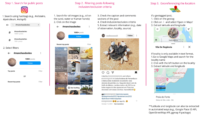
The searches were conducted from August 1, 2023, to December 15, 2023. Observations of oil spills were collected over two periods: from August 1, 2019, to August 31, 2020, and from January 1, 2022, to October 31, 2023. Initially, searches focused on recent observations from 2022 to 2023, using 50 pre-defined hashtags. From these, five hashtags were selected for further investigation related to the 2019/2020 oil spill, such as the hashtags #ManchasDeOleo and #ManchasDeÓleo (‘oil slicks’ in English). These hashtags were chosen based on their effectiveness in retrieving relevant data; in other words, they have less public content available but returned more observations of oil spills in Brazil (Supplementary Materials 1 and 2). The hashtag search filters on Instagram displayed “Top Posts” and “Recent Top Posts” based on the platform algorithm in the search period (Figure 1). Both filters were employed for searches corresponding to each hashtag in this study.
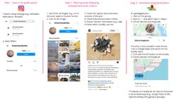
Steps for extracting oil spill records from Instagram. Adapted from Chowdhury et al. (2024).
FILTERING AND GEOREFERENCING OIL SPILL OBSERVATIONS
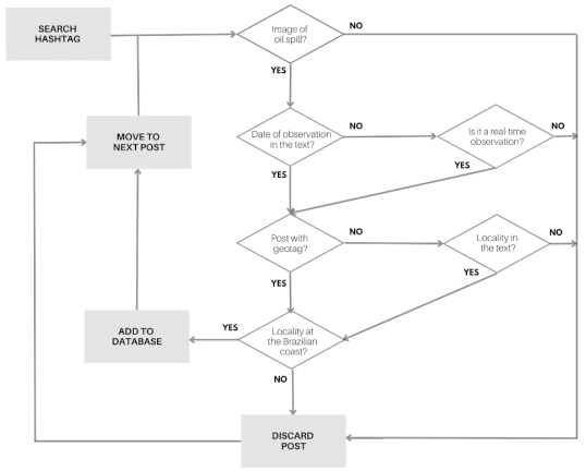
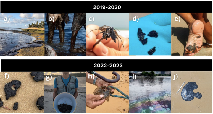
The Instagram posts were manually filtered via a binary classification to determine whether they depicted a record of oil image on the coast of Brazil. Only those posts that met all the inclusion criteria were included in the databases (Figure 2; Table 1). The first inclusion criterion was the image of oil on the sand, water, biota, or human body (e.g., hands, legs, and feet) (Figure 3). Posts containing images other than that (e.g., oil on the road or oil paintings) were excluded. The next step involved searching for the observation date provided by the users in the caption or comments section. When available, this date was extracted. If the observation date was absent from either the caption or comments, it was assumed that Instagram posts are typically on personal mobile devices as quick reactions to ephemeral moments. Therefore, the posting date would likely be very close to the actual observation date, indicating that it was a real-time recording or nearly so. The following criteria were used to exclude specific oil spill images from the analysis: a) posts with clues or evidence suggesting that the observation was not made in real-time (such as posts about environmental education or scientific dissemination about oil spills in general) and b) posts that contained memory-related terms or hashtags about a past moment (such as #tbt, which stands for “throwback Thursday” and indicates that the post references past events).
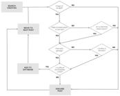
Summary of the methodology applied to search and filter oil spill observations on the coast of Brazil presented on Instagram posts and the inclusion/exclusion criteria.

Examples of images of posts from Instagram included in the database about oil observations along the coast of Brazil. a) Piatã Beach, Salvador, Bahia (11/10/2019); b) Paiva Beach, Cabo de Santo Agostinho, Pernambuco (22/10/2019); c) Tabatinga Beach, Conde, Paraíba (28/10/2019); d) Grussaí Beach, São João da Barra, Rio de Janeiro (23/11/2019); e) Porto de Galinhas Beach, Ipojuca, Pernambuco (21/06/2020); f) Delegado Beach, Arraial d’Ajuda, Bahia (25/08/2022); g) Maria Farinha Beach, Recife, Pernambuco (18/10/2022); h) Jacaraípe Beach, Serra, Espírito Santo (03/12/2022); i) Botafogo Beach, Rio de Janeiro (12/02/2023); j) Cumurupim Beach, Nísia Floresta, Rio Grande do Norte (26/09/2023).
Inclusion and exclusion criteria for filtering oil spill observations in Brazil from Instagram.
Then, we filtered those posts that included geospatial information along the coast of Brazil, with a minimum precision at the municipal level. The information regarding the observation location was extracted from the text of captions and comments or from geotags (location IDs with coordinates that users explicitly provide when posting). Geospatial data available only in text format is informative rather than definitive, so general areas were used to address the absence of specific coordinates for these observations. These general areas were then converted into approximate GPS coordinates using Google Maps (https://maps.google.com). Posts outside the coast of Brazil were discarded. Posts containing records of oil observations without detailed geographic information, for example, containing only the beach’s generic name (e.g., #praiadoforte), were also discarded.
The next step involved eliminating reposts and duplicates of the same observation to ensure that each record was represented exclusively by a single observation. At this stage, records from different localities, as well as records from the same locality but on different dates, were considered separate. Overall, two researchers independently reviewed each post to verify the oil spill record, confirm its location and timeframe, and remove duplicates and reposts. In addition to collecting spatiotemporal information, information about the potential sources of the oil spill was also extracted whenever available. Users who reported oil spill observations along the coast of Brazil were classified according to the profiles and channels outlined by Lemos et al. (2021). These classifications include independent media, traditional media, non-profit organizations, companies, influencers, independent users, official profiles, and political profiles. The social media users were anonymized to protect user privacy (Di Minin et al., 2021; Ghermandi et al., 2023).
For each post included in the database, the following information was recorded:
-
Name: The name of the locality.
-
Geotag: A web link to access the geotag (if available).
-
LATLONG: Geographic coordinates of the occurrence, including latitude and longitude.
-
Date of Upload: The date the post was created.
-
Observation Date: The date of observation (if available).
-
Source: The source of the oil spill (if available).
-
User: The name of the user who posted the image.
-
Profile: Classification of the user profile.
-
Hashtag: Any hashtag(s) in the post.
-
Data: Information on whether the spatiotemporal data were collected from the original post or the comments section.
-
URL: A web link to access the post.
RESULTS
2019/2020 OIL SPILLS
The hashtags #OleoNoNordeste and #ÓleoNoNordeste (‘oil in the northeast’) were linked to a significant number of records regarding the 2019/2020 oil spills in Brazil. These hashtags accounted for 91 and 85 records of the oil spill observations, respectively (Supplementary Material 1). The hashtags #ManchasDeÓleo and #ManchasdeOleo (‘oil slicks’) accounted for 67 and 49 records, respectively. A total of four posts were tagged with more than one of the hashtags used in the searches.
After removing reposts and duplicates (35 records), 312 records of oil observations related to the 2019/2020 oil spills on the Brazilian coast were included in the database (Supplementary Material 3). In total, 218 oil spill records were documented in 2019 and 94 in 2020. A total of 101 users contributed to these observations, most of which referring to independent media (32 users) and independent users (20 users).
Out of the total, 290 observation records derived from the images and texts available in the posts, whereas 22 came exclusively from the comments section. Examples of the images from the posts included in the database are shown in Figure 3. The oil slicks along the Brazilian coast in this study period showed various shapes and consistencies, such as emulsified oil covering broad areas (Figure 3a) and discrete oil accumulations (Figure 3e).
The exact date of observation was recorded in 137 records, with 119 of these observations occurring on the same date or within two days prior to the posting date. Only 37 geolocations were extracted from geotags; most (275 localities) were estimated solely based on text provided by users. Potential sources of oil spills were mentioned in 10 posts.
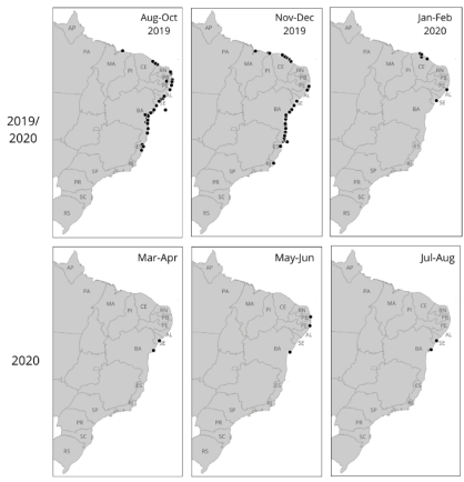
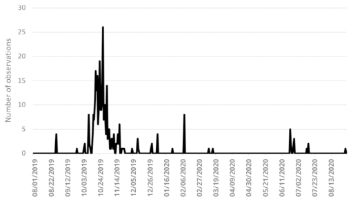
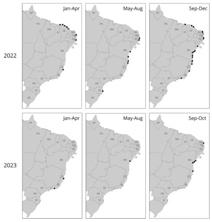
Oil spill observations were recorded for 11 states, 68 municipalities, 138 sandy beaches, three mangroves, and one archipelago along the Brazilian coast from August 30, 2019, to August 30, 2020, totaling 170 localities (Figure 4). The northernmost observation was recorded in Maranhão in September 2019 at coordinates 2°22’43.5” S; 43°16’44.3” W, while the southernmost observation took place in Rio de Janeiro in November 2019 at 21°37’34.4” S; 41°01’08.9” W (Figure 5).
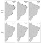
Maps of the distribution of oil observations (black dots) on the Brazilian coast extracted from Instagram from 1 August 2019 to 31 August 2020. Coastal states of Brazil: AP (Amapá); PA (Pará); MA (Maranhão); PI (Piauí); CE (Ceará); RN (Rio Grande do Norte); PB (Paraíba); PE (Pernambuco); AL (Alagoas); SE (Sergipe); BA (Bahia); ES (Espírito Santo); RJ (Rio de Janeiro); SP (São Paulo); PR (Paraná); SC (Santa Catarina); and RS (Rio Grande do Sul).
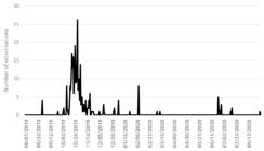
Frequency of oil observations on the Brazilian coast extracted from Instagram between 01 August 2019 and 31 August 2020.
The first record was obtained on August 30, 2019, in the state of Paraíba. From August to October 2019, a total of 209 records were collected along the Northeast coast of Brazil and the state of Espírito Santo, in the Brazilian Southeast. A similar pattern was observed from November to December 2019, during which 73 oil spill observations were recorded in the Brazilian Northeast and Southeast, particularly in the states of Ceará and Bahia. In January and February 2020, a total of 13 records were collected for the states of Ceará, Alagoas, and Sergipe. Additionally, two records were noted in Bahia and Sergipe in March 2020. In June 2020, 11 observations were documented for Alagoas, Pernambuco, and Bahia, followed by two records in Bahia and Sergipe in July and August 2020. Some users speculated about the possible origins of the oil spill that affected the beaches of the Brazilian Northeast and Southeast in 2019/2020, suggesting sources such as a Greek ship, a Greenpeace vessel, or a ship from Venezuela.
2022/2023 OIL SPILLS
The hashtags #ManchasDeOleo and #ManchasDeÓleo (meaning ‘oil slicks’) accounted for a significant portion of oil observation records related to the 2022/2023 oil spills along the coast of Brazil, contributing 61 and 27 records, respectively (Supplementary Material 2). Other notable hashtags included #OleoNasPraias (‘oil on the beaches;’ 16 records), #OleoNaPraia (‘oil on the beach;’ 13 records), and #ManchaDeOleo (‘oil slick;’ 11 records). A total of nine posts used more than one of the investigated hashtags.
After removing reposts and duplicates (eight records), 162 records of oil spill observations from the Brazilian coast from 2022 to 2023 were included in the database (Supplementary Material 4). In total, 2022 had more oil spill records along the Brazilian coast than 2023, with 143 reports in 2022 when compared to only 19 in 2023. These observations were reported by 79 users. Most observations came from independent media sources (44 users) and non-profit organizations (17 users).
Out of the total observations, 134 were extracted from images and texts available in the posts, whereas 23 were derived solely from the comments section. Figure 3 provides examples of the post images in the database. The oil slicks along the Brazilian coast in this study period showed various shapes and consistencies, such as highly weathered oil with a nearly solid consistency (Figure 3f) and liquid oil (Figure 3i).
The exact date of observation was present in 81 records, 54 of which occurred on the same date or up to two days before the posting date. Only 15 geolocations were taken from geotags; most (147 geolocations) were estimated based solely on text provided by users. Furthermore, the potential sources of oil spills were mentioned in three posts.
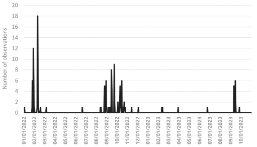
Oil spill observations were collected for 10 states, 48 municipalities, 88 sandy beaches, two mangroves, and one bay along the Brazilian coast from January 2, 2022, to September 26, 2023, totaling 111 localities (Figure 6). The northernmost observation was recorded in Piauí in October 2022 (2°48’27.9” S; 41°43’35.3” W), whereas the southernmost occurred in Santa Catarina in June 2022 (27°34’26.7” S; 48°31’09.3” W; Figure 7).
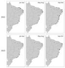
Maps of the distribution of oil observations (black dots) on the Brazilian coast that were extracted from Instagram from 1 January 2022 to 31 October 2023. Coastal states of Brazil: AP (Amapá); PA (Pará); MA (Maranhão); PI (Piauí); CE (Ceará); RN (Rio Grande do Norte); PB (Paraíba); PE (Pernambuco); AL (Alagoas); SE (Sergipe); BA (Bahia); ES (Espírito Santo); RJ (Rio de Janeiro); SP (São Paulo); PR (Paraná); SC (Santa Catarina); and RS (Rio Grande do Sul).
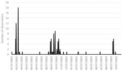
Frequency of oil observations on the Brazilian coast extracted from Instagram from 01 January 2022 to 31 October 2023.
During January and February of 2022, oil spill observations were recorded along the entire coast of Ceará, in the Brazilian Northeast, totaling 59 records. In August 2022, an oil spill was also observed on the coasts of Bahia and Pernambuco, with 22 records. Additionally, in September and October 2022, the oil spill was recorded not only in Bahia and Pernambuco but also on other beaches along the Northeast coast, including the states of Sergipe, Rio Grande do Norte, Piauí, and Ceará, amounting to 28 records in total.
The only record of the oil spill in the southern region of Brazil was extracted from the state of Santa Catarina, specifically in the Mangrove of Itacorubi, Florianópolis, on June 21, 2022. On the Southeast coast, records were obtained in the state of Rio de Janeiro, with two incidents in Guanabara Bay - one on October 4, 2022, and another on February 10, 2023. Additionally, another record was noted at Botafogo Beach on February 12, 2023, in which the source of the observed oil slicks was identified as a spill from a vessel. In Espírito Santo, also on the Southeast coast, oil spill observations were recorded in the municipality of Linhares on February 18, 2022, at Jacaraípe Beach on December 4, 2022, and again in Linhares on March 30, 2023. The latter spill in Linhares was potentially linked to a small oil production well.
On June 24, 2023, an oil spill was observed in the Madre de Deus Mangrove in Bahia, likely due to a spill from the Petrobras Transport refinery. In September 2023, 14 oil spill records were documented along the coast of Bahia. On September 15, oil contamination was noted at Barra Beach in Salvador, Bahia, which was possibly caused by an oil tanker. Additionally, an oil spill was reported at Camurupim Beach in Rio Grande do Norte on September 26, 2023.
DISCUSSION
Instagram serves as a cost-effective, large-scale, and real-time tool for providing georeferenced observations of oil spills. Social media platforms offer a rich data source. However, the large data volume can make it difficult to extract useful information. These platforms can be used to gather insights about human perceptions and communications related to coastal oil spills (Almeida et al., 2022; Lemos et al., 2021; Starbird et al., 2015; Sutton et al., 2013; Yin et al., 2015). Despite this potential, they have been underutilized for tracking and mapping oil spill observations (Aulov and Halem, 2012; Ivanda et al., 2021). Using an extensive list of hashtags, this is the first initiative to outline a detailed method for searching and collecting georeferenced images of oil spills using social media platforms.
Among the most popular social media platforms worldwide, Instagram enables its users to capture specific characteristics of time and space via photographs or videos. The mobile, social, and visual aspects are fundamental to this platform, providing a large volume of georeferenced images and texts that are often generated in real time (Leaver et al., 2020). Previous studies have shown the potential of Instagram in providing georeferenced and real-time coastal observations (Aulov et al., 2014; Nascimento et al., 2024a; Rocha et al., 2024; Sullivan et al., 2019). This platform has also been used to understand how the 2019 oil spill influenced social attitudes in Brazil (Almeida et al., 2022) and to monitor the Brazilian Navy tagging on posts during this event (IBAMA, 2020). In this study, it was shown for the first time the contribution of Instagram to tracking large-scale oil spills, as well as sporadic occurrences of oil on the Brazilian coast.
The data extracted from Instagram were consistent with previous oil spill observations in the literature (Azevedo et al., 2022; Bérgamo et al., 2023; Martins et al., 2024; Mello et al., 2023; Soares et al., 2020, 2022, 2023). Similar to previous observations (IBAMA, 2020; Soares et al., 2022), oil spills were recorded in 11 states in 2019/2020, primarily along the Northeast coast. The largest volume of data from social media was collected during the acute phase of oil arrival, specifically from September to December 2019. The highest volume of oil and the greatest number of affected sites were recorded in this period (Nobre et al., 2022; Soares et al., 2022; this study). The initial detection of oil along the coast occurred in the municipalities of Conde and Pitimbu, in the State of Paraíba, on August 30, 2019 (Lemos et al., 2024). This finding was consistent with information obtained from Instagram. Additionally, oil fragments were intermittently observed in 2020 (Reddy et al., 2022; Soares et al., 2022), a trend also noted in this study. The filtering criteria applied for extracting social media data effectively captured the distribution trend of actual oil observation records along the Brazilian coast during the 2019/2020 oil spill. This methodology also proved successful for recent observations of oil spills in 2022/2023 (Azevedo et al., 2022; Soares et al., 2023).
From the end of January to the first half of February 2022, oil spill observations were reported on beaches in the state of Ceará, in Northeast Brazil, via Instagram. This aligns with previous records (Azevedo et al., 2022; Soares et al., 2023). Additionally, as noted on social media, oil reappeared along the Northeast coast from August to November 2022 (Bérgamo et al., 2023; Mello et al., 2023). During this period, oil samples, including tarballs with barnacles of the species Lepas spp., were collected from the beaches of Pernambuco from August to September 2022 (Bérgamo et al., 2023) and from Ceará and Rio Grande do Norte from September to October 2022 (Mello et al., 2023). In this study, an image shared by an independent user also showed Lepas spp. attached to a tarball in October 2022 (Figure 1). This result highlights the potential of social media to contribute to the observation of poorly documented records since this event has never been seen or reported before in the Atlantic Ocean (Mello et al., 2023).
Oil tarballs had been observed in Bahia, in Northeastern Brazil, in September 2023 (Martins et al., 2024). Using social media, oil was also recorded in Bahia and Rio Grande do Norte from September 10 to 26, 2023. An analysis of saturated and aromatic compounds, along with ocean surface circulation patterns, indicates that the oil was discharged close to the Brazilian shore to the east or southeast of Salvador, Bahia, by a tanker on an international route in the South Atlantic (Martins et al., 2024). Probabilistic simulations conducted over the past 30 years show that the Brazilian Equatorial and Northeast coasts are particularly vulnerable to oceanic dumping by ships along the South Atlantic route (Zacharias et al., 2023). Additionally, the Southeast coast is considered a petroleum “hot spot” in Brazil due to numerous platforms and heavy ship traffic (Gusmão et al., 2000), also making this region particularly vulnerable to oil spills, as observed herein.
In addition to correlating with records in the literature, this study on social media has served as a valuable source of new observations regarding chronic oil contamination off the Brazilian coast (Andrade and Coutinho, 2022; Lourenço et al., 2023). Independent media profiles, non-profit organizations, and individual users reported most oil spill observations. This suggests that social media platforms may contain important information about oil spills that have yet to reach mainstream media and official communication channels. However, further research is needed to assess the effectiveness of Instagram for the early detection of oil spills.
Visual data, such as photographs, is valuable for enhancing our understanding of geographic information and can aid in preventing and mitigating damage caused by oil spills (Souto and Batalhão, 2022). The oil slicks along the Brazilian coast in this study showed various shapes and consistencies in both investigations, indicating they originated from different periods of exposure to the physical and chemical weathering of the oil, such as unweathered liquid oil and tarballs (NOAA, 2013). Each phase of oil decomposition requires different mitigation techniques, such as mechanical recovery and manual collection of tars (IBAMA, 2020). Therefore, observations of oil spills collected from social media can also be valuable for enhancing cleaning processes. However, relying solely on images and geotag data are insufficient for gathering spatiotemporal information from Instagram. This study also emphasizes the importance of text data in collecting relevant information from social media. For instance, approximately 90% of the geographic information was obtained exclusively from user-generated text found in captions and comments.
While it does not require citizen engagement or the collection of participatory records, the amount of data gathered from spontaneous social media posts can exceed that from voluntary initiatives, showing an advantage of the current methodology (Nascimento et al., 2024b). This study included 170 locations of oil spills in Brazil during the 2019/2020 oil spill; this data volume is nearly double the registrations from a previous initiative that aimed to gather voluntary observations of oil spills in Brazil during the same period (Souto and Batalhão, 2022). However, collecting historical data from social media may encounter challenges due to limitations within the platform system, such as difficulties loading search results (Nascimento et al., 2024b). Consequently, we expect that real-time social media monitoring will more effectively collect substantial amounts of accurate data about oil spills.
Social media has proven to be helpful in collecting images and spatiotemporal information about oil spills in Brazil. However, when using these platforms, it is important to consider uncertainties regarding the dates and locations of observations (Chowdhury et al., 2024; Sullivan et al., 2019). One limitation of spatiotemporal data extracted from social media in coastal areas is the biases toward urban areas and the summer/vacation season (Ghermandi and Sinclair, 2019; Nascimento et al., 2024a). A possible way to mitigate these data biases and uncertainties is by combining social media data with ground-truthing sources to validate records from social media (Di Minin et al., 2015; Ghermandi et al., 2023; Ivanda et al., 2021).
Another challenge in social media investigations is finding a balance between being transparent about the method used and protecting the privacy of social media users (Di Minin et al., 2021; Ghermandi et al., 2023). In this study, only publicly available posts were used. Data were anonymized. In Brazil, the General Protection Law safeguards citizens against unauthorized data storage in the digital environment, thus ensuring privacy and freedom. This law defines anonymized data as information that has been processed to eliminate any possibility of directly or indirectly identifying individuals, thereby making it non-personal. In this study, data minimization and anonymization strategies were used to reduce the risk of user re-identification. For instance, sensitive data displayed in graphical content (Figure 1) was suppressed, and original web links were also removed (see Supplementary materials; Nascimento et al. 2024a). Additionally, generalization techniques were applied by replacing specific information with broader categories, which decreased identifiability while preserving the analytical usefulness of the data, particularly in user profile classifications collected for this study. Furthermore, tokenization was used to replace personal data, such as usernames, with a non-personal “token” to safeguard the information during data analysis.
Given the vast volume of information continuously posted on social media about various topics, finding valuable data related to oil spills from ordinary unstructured posts is both essential and challenging. Many social media posts lack coherence and proper punctuation and may contain grammatical errors. Readers may be able to infer the authors’ intentions based on contextual cues and event circumstances, but computational algorithms struggle to do the same (Guo et al., 2023). The manual filtering process is the most effective method to minimize false classification and remove irrelevant posts (Chowdhury et al., 2024; Guo et al., 2023). However, the process of compiling extensive social media data is time-consuming and involves multiple steps. In disasters and emergencies, timely access to information is crucial. Automation could significantly reduce the time required for this task (e.g., Ivanda et al., 2021). Data can be compiled more efficiently via social media Application Programming Interfaces (API), but it is important to note that Instagram provides no such access for research. As an alternative for platforms that offer no free API access, web scraping tools can be used to obtain machine-readable data, such as Instaloader for Instagram (Camargo et al., 2023). The manual protocol developed here can serve as a foundation for a future automated coastal surveillance system using social media.
CONCLUSIONS AND RECOMMENDATIONS
This study emphasizes the potential of Instagram as a tool for enhancing coastal surveillance systems for oil spills. Despite some limitations in the used method, social media has proven to be a valuable source of oil spill records during large-scale oil spills and sporadic occurrences along the Brazilian coast. The data collected from Instagram aligned itself with previous observations in the literature and showed unpublished records. However, this research is based on only two case studies in Brazil. To further develop and operationalize this monitoring system via social media, it will be necessary to compile additional oil spills to improve the methodology. Automating the manual processes in this study is essential to transform this monitoring system into a scalable solution. Future automated investigations may focus on hashtags with less public data that have generated a higher volume of positive posts related to oil spill observations, such as #ManchasDeOleo and #ManchasDeÓleo. While automating the data collection process may offer challenges, future research could also include data from additional social media platforms, such as Facebook and YouTube, to compare their capabilities and contributions. The data collected from social media can be combined with satellite imagery, ocean modeling, oil fingerprinting, and ecological information. This integration can enhance the assessment of potential oil spill sources and help anticipate future scenarios, supporting the goals of the SisMOM project.
DATA AVAILABILITY STATEMENT
We confirm that the data supporting the findings of this study are available within its supplementary materials.
SUPPLEMENTARY MATERIAL
Supplementary materials include a list of hashtags used to search for oil spill observations on Instagram, along with the approximate number of publicly available posts and the number of records featured in the baseline for each hashtag related to the oil spill incidents from 2019-2020 and 2022-2023 (refers to Supplementary Material 1 and 2, respectively). Additionally, these materials provide a compilation of oil spill observations along the Brazilian coast for the incidents occurring in 2019-2020 and 2022-2023 (see Supplementary Material 3 and 4, respectively).
Supplementary Material 1
Supplementary Material 2
Supplementary Material 3
Supplementary Material 4
ACKNOWLEDGMENTS
We are grateful to all anonymous users who contributed data for this study through social media. We extend our thanks to CAPES (Coordination for the Improvement of Higher Education Personnel) for granting the doctoral scholarship, as well as to CNPq (National Council for Scientific and Technological Development) and the Brazilian Navy for the financial support of the Multiscale Oil Spill Detection and Modeling System project. Additionally, we appreciate the valuable feedback from the five anonymous reviewers on the manuscript.
REFERENCES
-
Almeida, J. A., Guedes-Santos, J., Vieira, F. A., Azevedo, A. K., Souza, C. N., Pinheiro, B. R., Correia, R. A., Malhado, A. C. M. & Ladle, R. J. 2022. Public awareness and engagement in relation to the coastal oil spill in northeast Brazil. Anais da Academia Brasileira de Ciências, 94(suppl 2). DOI: https://doi.org/10.1590/0001-3765202220210395
» https://doi.org/10.1590/0001-3765202220210395 -
Andrade, J. B. D. & Coutinho, R. 2022. Oil spill on the Brazilian coast. Anais da Academia Brasileira de Ciências, 94(suppl 2). DOI: https://doi.org/10.1590/0001-37652021202220220905
» https://doi.org/10.1590/0001-37652021202220220905 -
Asif, Z., Chen, Z., An, C. & Dong, J. 2022. Environmental impacts and challenges associated with oil spills on shorelines. Journal of Marine Science and Engineering, 10(6), 762. DOI: https://doi.org/10.3390/jmse10060762
» https://doi.org/10.3390/jmse10060762 -
Aulov, O. & Halem, M. 2012. Human sensor networks for improved modeling of natural disasters. Proceedings of the IEEE, 100(10), 2812-2823. DOI: https://doi.org/10.1109/JPROC.2012.2195629
» https://doi.org/10.1109/JPROC.2012.2195629 - Aulov, O., Price, A. & Halem, M. 2014. AsonMaps: A platform for aggregation visualization and analysis of disaster related human sensor network observations. In: International ISCRAM Conference (11th ed., pp. 802-806).
-
Azevedo, R. N., Bezerra, K. M., Nascimento, R. F., Nelson, R. K., Reddy, C. M., Nascimento, A. P., Oliveira, A. H. B., Martins, L. L. & Cavalcante, R. M. 2022. Is there a similarity between the 2019 and 2022 oil spills that occurred on the coast of Ceará (Northeast Brazil)? An analysis based on forensic environmental geochemistry. Environmental Pollution, 314, 120283. DOI: https://doi.org/10.1016/j.envpol.2022.120283
» https://doi.org/10.1016/j.envpol.2022.120283 -
Bhattacharjee, S. & Dutta, T. 2022. Chapter 1 - An overview of oil pollution and oil-spilling incidents. In: Das, P., Manna, S. & Pandey, J. K. (Ed.). Advances in oil-water separation (pp. 3-15). Elsevier. DOI: https://doi.org/10.1016/B978-0-323-89978-9.00014-8
» https://doi.org/10.1016/B978-0-323-89978-9.00014-8 -
Bérgamo, D. B., Craveiro, N., Magalhães, K. M., Yogui, G. T., Soares, M. O., Zanardi-Lamardo, E., Rojas, L. A. V., Lima, M. C. S. & Rosa Filho, J. S. 2023. Tar balls as a floating substrate for long-distance species dispersal. Marine Pollution Bulletin, 196, 115654. DOI: https://doi.org/10.1016/j.marpolbul.2023.115654
» https://doi.org/10.1016/j.marpolbul.2023.115654 -
Beyer, J., Trannum, H. C., Bakke, T., Hodson, P. V. & Collier, T. K. 2016. Environmental effects of the Deepwater Horizon oil spill: a review. Marine Pollution Bulletin, 110(1), 28-51. DOI: https://doi.org/10.1016/j.marpolbul.2016.06.027
» https://doi.org/10.1016/j.marpolbul.2016.06.027 -
Blondeau-Patissier, D., Schroeder, T., Suresh, G., Li, Z., Diakogiannis, F. I., Irving, P., Witte, C. & Steven, A. D. 2023. Detection of marine oil-like features in Sentinel-1 SAR images by supplementary use of deep learning and empirical methods: Performance assessment for the Great Barrier Reef marine park. Marine Pollution Bulletin, 188, 114598. DOI: https://doi.org/10.1016/j.marpolbul.2023.114598
» https://doi.org/10.1016/j.marpolbul.2023.114598 - Camargo, L. D. S., Rocha, H., do Nascimento, L. S. & Hara, C. 2023. Coleta de dados do Instagram sobre ocorrências de caravelas-portuguesas na costa brasileira. In: Escola Regional de Banco de Dados (ERBD) (pp. 51-59). SBC.
- Carneiro, A., Nascimento, L. S., Noernberg, M. A., Hara, C. S. & Pozo, A. T. R. 2024. Social media image classification for jellyfish monitoring. Aquatic Ecology, 58(1), 3-15.
-
Chowdhury, S., Ahmed, S., Alam, S., Callaghan, C. T., Das, P., Di Marco, M., Di Minnin, E., Jaric, I., Labi, M. M., Rokonuzzaman, Md., Roll, U., Sbragaglia, V., Siddika, A. & Bonn, A. 2024. A protocol for harvesting biodiversity data from Facebook. Conservation Biology, 38(4), e14257. DOI: https://doi.org/10.1111/cobi.14257
» https://doi.org/10.1111/cobi.14257 -
Di Minin, E., Tenkanen, H. & Toivonen, T. 2015. Prospects and challenges for social media data in conservation science. Frontiers in Environmental Science, 3. DOI: https://doi.org/10.3389/fenvs.2015.00063
» https://doi.org/10.3389/fenvs.2015.00063 -
Di Minin, E., Fink, C., Hausmann, A., Kremer, J. & Kulkarni, R. 2021. How to address data privacy concerns when using social media data in conservation science. Conservation Biology, 35(2), 437-446. DOI: https://doi.org/10.1111/cobi.13708
» https://doi.org/10.1111/cobi.13708 -
Dong, J., Asif, Z., Shi, Y., Zhu, Y. & Chen, Z. 2022. Climate change impacts on coastal and offshore petroleum infrastructure and the associated oil spill risk: a review. Journal of Marine Science and Engineering, 10(7), 849. DOI: https://doi.org/10.3390/jmse10070849
» https://doi.org/10.3390/jmse10070849 -
Fioravanti, C. 2019. Os caminhos da mancha. Revista Pesquisa Fapesp, ed. 286. Available from: Available from: https://revistapesquisa.fapesp.br/2019/12/03/os-caminhos-da-mancha/ Access date: 2025 dec. 5.
» https://revistapesquisa.fapesp.br/2019/12/03/os-caminhos-da-mancha/ -
Ghermandi, A. & Sinclair, M. 2019. Passive crowdsourcing of social media in environmental research: A systematic map. Global environmental change, 55, 36-47. DOI: https://doi.org/10.1016/j.gloenvcha.2019.02.003
» https://doi.org/10.1016/j.gloenvcha.2019.02.003 -
Ghermandi, A., Langemeyer, J., Van Berkel, D., Calcagni, F., Depietri, Y., Vigl, L. E., Fox, N., Havinga, I., Jäger, H., Kaiser, N., Karasov, O., McPhearson, T., Podschun, S., Ruiz-Frau, A., Sinclair, M., Venohr, M. & Wood, S. A. 2023. Social media data for environmental sustainability: A critical review of opportunities, threats, and ethical use. One Earth, 6(3), 236-250. DOI: https://doi.org10.1016/j.oneear.2023.02.008
» https://doi.org10.1016/j.oneear.2023.02.008 -
Guo, K., Guan, M., Yan, H. 2023. Utilising social media data to evaluate urban flood impact in data-scarce cities. International journal of disaster risk reduction, 93, 103780. DOI: https://doi.org/10.1016/j.ijdrr.2023.103780
» https://doi.org/10.1016/j.ijdrr.2023.103780 - Gusmão, P., Santos, B. & Zani, M. 2000. Gestão territorial na zona costeira do sudeste brasileiro e a geografia da cadeia produtiva do petróleo. In: Encontro de geógrafos da América Latina, XIV, 8 (pp. 1-19).
-
Houston, J. B., Hawthorne, J., Perreault, M. F., Park, E. H., Hode, M. G., Halliwell, M. R., McGowen, S. E., Davis, R., Vaid, S., McElderry, J. A. & Griffith, S. A. 2015. Social media and disasters: a functional framework for social media use in disaster planning, response, and research. Disasters, 39(1), 1-22. DOI: https://doi.org/10.1111/disa.12092
» https://doi.org/10.1111/disa.12092 -
IBAMA (Instituto Brasileiro do Meio Ambiente e dos Recursos Naturais). 2019. Manchas de óleo no litoral Brasileiro - database. Available from: Available from: https://www.brasil.gov.br/manchanolitoral/ Access date: 2025 Dec. 5.
» https://www.brasil.gov.br/manchanolitoral/ -
IBAMA (Instituto Brasileiro do Meio Ambiente e dos Recursos Naturais). 2020. Incidente de poluição por óleo na costa brasileira. Rio de Janeiro, 2020. Available from: Available from: https://www.gov.br/ibama/pt-br/assuntos/fiscalizacao-e-protecao-ambiental/emergencias-ambientais/manchasdeoleo/arquivos/2023/20230118_Of_Ext_30_279_2020_CM_MMA_An_Incidente_Poluicao_Oleo_Relatorio_final.pdf/ Access date: 2022 Mar. 1.
» https://www.gov.br/ibama/pt-br/assuntos/fiscalizacao-e-protecao-ambiental/emergencias-ambientais/manchasdeoleo/arquivos/2023/20230118_Of_Ext_30_279_2020_CM_MMA_An_Incidente_Poluicao_Oleo_Relatorio_final.pdf/ - Ivanda, A., Mladenović, S., Šerić, L. & Braović, M. 2021. An assessment of social media oil spill reports using transfer learning on remotely sensed images. In: International Conference on Smart and Sustainable Technologies (SpliTech) (6th ed., pp. 1-6).
- Leaver, T., Highfield, T. & Abidin, C. 2020. Instagram: Visual social media cultures. Cambridge, John Wiley & Sons.
-
Lemos, A. L. M., Bitencourt, E. C. & Santos, J. G. B. 2021. Fake news as fake politics: the digital materialities of YouTube misinformation videos about Brazilian oil spill catastrophe. Media, Culture & Society, 43(5), 886-905. DOI: https://doi.org/10.1177/0163443720977301
» https://doi.org/10.1177/0163443720977301 -
Lemos, A., Andrade, L., Franklin, L., Bezerra, D., Ghisolfi, R., Maita, R. & Nobre, P. 2024. Ship route oil spill modeling: a case study of the Northeast Brazil event, 2019. Applied Sciences, 14(2), 865. DOI: https://doi.org/10.3390/app14020865
» https://doi.org/10.3390/app14020865 -
Lourenço, R. A., Combi, T., Alexandre, M. da R., Sasaki, S. T., Zanardi-Lamardo, E. & Yogui, G. T. 2020. Mysterious oil spill along Brazil’s northeast and southeast seaboard (2019-2020): Trying to find answers and filling data gaps. Marine Pollution Bulletin, 156, 111219. DOI: https://doi.org/10.1016/j.marpolbul.2020.111219
» https://doi.org/10.1016/j.marpolbul.2020.111219 -
Lourenço, R. A., Lassalle, G., Scafutto, R. D. P. M. & Souza Filho, C. R. 2023. Recurrent arrival of oil spill remnants along the Brazilian coast: In situ long-term weathering of the largest spill in Brazil’s history. Regional Studies in Marine Science, 66, 103175. DOI: https://doi.org/10.1016/j.rsma.2023.103175
» https://doi.org/10.1016/j.rsma.2023.103175 -
Martins, L. L., Pereira, V. B., Nascimento, A. P., Azevedo, R. N. A., Oliveira, A. H., Teixeira, C. E. P., Azevedo, D. A., Cruz, G. F., Cavalcante, R. M. & Giarrizzo, T. 2024. Forensic geochemistry reveals international ship dumping as a source of new oil spill in Brazil’s coastline (Bahia) in late 2023. Environmental Science & Technology, 58(21), 9328-9338. DOI: https://doi.org/10.1021/acs.est.4c01520
» https://doi.org/10.1021/acs.est.4c01520 -
Mello, L. C., Nascimento, A. P., Lopes, B. D., Lima, A. D., Bezerra, L. E., Mendes, L. D. F., Bastos, L. M., Nossol, A. B. S., Martins, M. M., Martins, L. L. & Cavalcante, R. M. 2023. Tarballs on the Brazilian coast in late 2022 sustain Lepas anatifera Linnaeus, 1758 (Crustacea: Cirripedia): Occurrence and risk of petroleum hydrocarbon ingestion. Science of the Total Environment, 896, 164981. DOI: https://doi.org/10.1016/j.scitotenv.2023.164981
» https://doi.org/10.1016/j.scitotenv.2023.164981 -
Nascimento, L. S., Noernberg, M. A., Bleninger, T. B., Lindner, A. & Nogueira Júnior, M. 2024a. Not such a rare species, after all? Insights into Drymonema gorgo Müller 1883 (Cnidaria, Scyphozoa), a large and little-known jellyfish from Brazil. Aquatic Ecology, 58(1), 17-30. DOI: https://doi.org/10.1007/s10452-023-10074-2
» https://doi.org/10.1007/s10452-023-10074-2 -
Nascimento, L. S., Nogueira Júnior, M., Hara, C. S. & Noernberg, M. A. 2024b. Passive citizen science: social media as a tool for marine wildlife observation. Marine Ecology Progress Series, 740, 219-233. DOI: https://doi.org/10.3354/meps14629
» https://doi.org/10.3354/meps14629 - NOAA (National Oceanic and Atmospheric Administration). 2013. Shoreline Assessment Manual (4th ed.). Seattle, Emergency Response Division, Office of Response and Restoration, National Oceanic and Atmospheric Administration.
-
Nobre, P., Lemos, A. T., Giarolla, E., Camayo, R., Namikawa, L., Kampel, M., Rudorff, N., Bezerra, D. X., Lorenzzetti, J., Gomes, J., Silva Jr., M. B., Lage, C. P. M., Paes, R. L., Beisl, C., Lobão, M. M., Bignelli, P. A., Moura, N., Galvão, W. S. & Polito, P. S. 2022. The 2019 northeast Brazil oil spill: scenarios. Anais da Academia Brasileira de Ciências, 94(suppl 2), e20210391. DOI: https://doi.org/10.1590/0001-3765202220210391
» https://doi.org/10.1590/0001-3765202220210391 -
Oliveira, O. M. C., Queiroz, S., Cerqueira, J. R., Soares, S. A. R, Garcia, K. S., Pavani Filho, A., Rosa, M. L. S., Suzart, C. M., Pinheiro, L. L. & Moreira, I. T. A. 2020. Environmental disaster in the northeast coast of Brazil: forensic geochemistry in the identification of the source of the oily material. Marine Pollution Bulletin, 160, 111597. DOI: https://doi.org/10.1016/j.marpolbul.2020.111597
» https://doi.org/10.1016/j.marpolbul.2020.111597 -
Reddy, C. M., Nelson, R. K., Hanke, U. M., Cui, X., Summons, R. E., Valentine, D. L., Rodgers, R. P., Chacón-Patiño, M. L., Niles, S. F., Teixeira, C. E. P., Bezerra, L. E. A., Cavalcante, R. M., Soares, M. O., Oliveira, A. H. B., White, H. K., Swarthout, R. F., Lemkau, K. L. & Radovic, J. R. 2022. Synergy of analytical approaches enables a robust assessment of the Brazil mystery oil spill. Energy & Fuels, 36(22), 13688-13704. DOI: https://doi.org/10.1021/acs.energyfuels.2c00656
» https://doi.org/10.1021/acs.energyfuels.2c00656 -
Rocha, H. F., Nascimento, L. S., Camargo, L., Noernberg, M. A., Ramirez, P. A. T. & Hara, C. S. 2024. Identifying Occurrences of the Cnidarian Physalia physalis in Social Media Data. Computer Science and Information Systems, (00), 64-64. DOI: https://doi.org/10.2298/CSIS240301064R
» https://doi.org/10.2298/CSIS240301064R -
Singh, H., Bhardwaj, N., Arya, S. K. & Khatri, M. 2020. Environmental impacts of oil spills and their remediation by magnetic nanomaterials. Environmental Nanotechnology, Monitoring & Management, 14, 100305. DOI: https://doi.org/10.1016/j.enmm.2020.100305
» https://doi.org/10.1016/j.enmm.2020.100305 -
Soares, M. O., Teixeira, C. E. P., Bezerra, L. E. A., Paiva, S. V., Tavares, T. C. L., Garcia, T. M., Araújo, J. T., Campos, C. C., Ferreira, S. M. C., Matthews-Cascon, H., Frota, A., Mont’Alverne, T. C. F., Silva, S. T., Rabelo, E. F., Barroso, C. X., Freitas, J. E. P., Melo Júnior, M., Campelo, R. P. S., Santana, C. S., Carneiro, P. B. M. & Cavalcante, R. M. 2020. Oil spill in South Atlantic (Brazil): environmental and governmental disaster. Marine Policy, 115, 103879. DOI: https://doi.org/10.1016/j.marpol.2020.103879
» https://doi.org/10.1016/j.marpol.2020.103879 -
Soares, M. O., Teixeira, C. E. P., Bezerra, L. E. A., Rabelo, E. F., Castro, I. B. & Cavalcante, R. M. 2022. The most extensive oil spill registered in tropical oceans (Brazil): the balance sheet of a disaster. Environmental Science and Pollution Research, 29(13), 19869-19877. DOI: https://doi.org/10.1007/s11356-022-18710-4
» https://doi.org/10.1007/s11356-022-18710-4 -
Soares, M. O., Brandão, D. B., Teixeira, C. E. P., Cavalcante, R. M., Oliveira, A. H. B., Bezerra, L. E. A. & Barros, E. L. 2023. Déjà vu: New oil spill poses cumulative risks to protected coastal environments in the South Atlantic. Marine Policy, 155, 105764. DOI: https://doi.org/10.1016/j.marpol.2023.105764
» https://doi.org/10.1016/j.marpol.2023.105764 -
Souto, R. D. & Batalhão, A. C. 2022. Citizen science as a tool for collaborative site-specific oil spill mapping: the case of Brazil. Anais da Academia Brasileira de Ciências, 94(suppl 2), e20211262. DOI: https://doi.org/10.1590/0001-3765202220211262
» https://doi.org/10.1590/0001-3765202220211262 -
Starbird, K., Dailey, D., Walker, A. H., Leschine, T. M., Pavia, R. & Bostrom, A. 2015. Social media, public participation, and the 2010 BP Deepwater Horizon oil spill. Human and Ecological Risk Assessment: An International Journal, 21(3), 605-630. DOI: https://doi.org/10.1080/10807039.2014.947866
» https://doi.org/10.1080/10807039.2014.947866 -
Sullivan, M., Robinson, S. & Littnan, C. 2019. Social media as a data resource for #monkseal conservation. PLOS One, 14(10), e0222627. DOI: https://doi.org/10.1371/journal.pone.0222627
» https://doi.org/10.1371/journal.pone.0222627 -
Suneel, V., Rao, V. T., Suresh, G., Chaudhary, A., Vethamony, P. & Ratheesh, R. 2019. Oil pollution in the Eastern Arabian Sea from invisible sources: a multi-technique approach. Marine Pollution Bulletin, 146, 683-695. DOI: https://doi.org/10.1016/j.marpolbul.2019.07.015
» https://doi.org/10.1016/j.marpolbul.2019.07.015 - Sutton, J., Spiro, E., Butts, C., Fitzhugh, S., Johnson, B. & Greczek, M. 2013. Tweeting the spill: online informal communications, social networks, and conversational microstructures during the Deepwater Horizon oilspill. International Journal of Information Systems for Crisis Response and Management, 5(1), 58-76.
-
Toivonen, T., Heikinheimo, V., Fink, C., Hausmann, A., Hiippala, T., Järv, O., Tenkanen, H. & Di Minin, E. 2019. Social media data for conservation science: A methodological overview. Biological Conservation, 233, 298-315. DOI: https://doi.org/10.1016/j.biocon.2019.01.023
» https://doi.org/10.1016/j.biocon.2019.01.023 - Yin, J., Feng, J. & Wang, Y. 2015. Social media and multinational corporations’ corporate social responsibility in China: the case of ConocoPhillips oil spill incident. IEEE Transactions on Professional Communication, 58(2), 135-153.
-
Zacharias, D. C., Gama, C. M., Fornaro, A. 2021a. Mysterious oil spill on Brazilian coast: analysis and estimates. Marine Pollution Bulletin, 165, 112125. DOI: https://doi.org/10.1016/j.marpolbul.2021.112125
» https://doi.org/10.1016/j.marpolbul.2021.112125 -
Zacharias, D. C., Gama, C. M., Rocha, R. P., Harari, J. & Fornaro, A. 2021b. Mysterious oil spill on the Brazilian coast - part 2: a probabilisc approach to fill gaps of uncertaines. Marine Pollution Bulletin, 173, 113085. DOI: https://doi.org/10.1016/j.marpolbul.2021.113085
» https://doi.org/10.1016/j.marpolbul.2021.113085 -
Zacharias, D. C., Crespo, N. M., da Silva, N. P., da Rocha, R. P., Gama, C. M., Silva, S. B. R. & Harari, J. 2023. Oil reaching the coast: Is Brazil on the route of international oceanic dumping?. Marine Pollution Bulletin, 196, 115624. DOI: https://doi.org/10.1016/j.marpolbul.2023.115624
» https://doi.org/10.1016/j.marpolbul.2023.115624 -
Zacharias, D. C., Lemos, A. T., Keramea, P., Dantas, R. C., da Rocha, R. P., Crespo, N. M., Sylaios, G., Jovane, L., Santos, I. G. S., Montone, R. C., Soares, M. O. & Lourenço, R. A. 2024. Offshore oil spills in Brazil: an extensive review and further development. Marine Pollution Bulletin, 205, 116663. DOI: https://doi.org/10.1016/j.marpolbul.2024.116663
» https://doi.org/10.1016/j.marpolbul.2024.116663 - Zhang, B., Matchinski, E. J., Chen, B., Ye, X., Jing, L. & Lee, K. 2019. Marine oil spills - Oil pollution, sources and effects. In: Sheppard, C. (Ed.). World seas: an environmental evaluation (pp. 391-406). Academic Press.