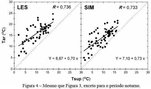
This study retrieved surface albedo (αs ) and land surface temperature Tsur using remote sensing data in order to provide information for studies of Urban Heat Island (UHI) in the city of Londrina (Paraná). We have used αs and Tsur data from the MODIS sensor, and in situ measurements of near-surface air temperature (Tair) acquired between June and August 2011 at 13 sites across the city area. The albedo and surface temperature data were used to calculate an urbanization index (UI), and further compared with Tair. In general, the data analysis of αs and Tsur was consistent with the in situ measurements, showing its applicability in the assessment of the spatial-temporal features of UHI. The urban area of Londrina showed UI values between 18 and 20, whilst vegetated areas had values between 14 and 16. The values are consistent with other studies, representing a useful methodology to assess the spatial-temporal evolution of urban areas. The index can also provide detailed information to assess the impact of land cover change on local and regional climate. Moreover, the results indicate that satellite data can greatly assist in the quantification of UHI when in situ air temperature data are unavailable.
Land surface albedo; Land surface temperature; Air temperature; Urban index; Urban heat island


