Do environmental and anthropogenic factors condition woody biomass recovery after forest harvesting in the Caatinga?
ABSTRACT
Sustainable management of native forests requires a clear understanding of the conditions that sustain productive capacity in harvested stands. Effective management planning therefore depends on understanding how spatial variation in environmental conditions and anthropogenic use within managed areas influence forest productivity. Using a case study approach, we evaluated how woody biomass recovery responds to local environmental and anthropogenic factors. Data were collected from seven annual production units, and linear models were applied to explain patterns of basal area recovery as a function of precipitation, soil depth and bulk density, plot elevation and slope, grazing indicators, and distance from plots to the farmstead. A significant pattern emerged: plots receiving higher mean annual precipitation and those located farther from the farmstead exhibited larger basal areas. In some cases, however, these relationships were not fully consistent, suggesting that additional environmental and anthropogenic factors contribute to biomass recovery following forest harvesting. Overall, our results support the hypothesis that regeneration and productivity in managed forests depend not only on individual attributes, such as mean precipitation or anthropogenic disturbances, but also on complex interactions among multiple edaphoclimatic and ecological factors, the intensity of human interventions, and their spatial variability across the management area.
Keywords:
Biomass production; Forest regeneration; Chronic anthropogenic disturbances; Sustainable forest management; Seasonally dry tropical forest.
RESUMO
A sustentabilidade do manejo de florestas nativas requer o conhecimento das condições que propiciam a manutenção da capacidade produtiva dos povoamentos explorados. Inicialmente, o planejamento do manejo exige compreender como a variação dos fatores ambientais e de uso antrópico das áreas manejadas influenciam a produtividade. Baseados em um estudo de caso, avaliamos como a recuperação da biomassa lenhosa é influenciada pela variação local de fatores ambientais e antrópicos. Coletamos dados em 7 unidades de produção anual e aplicamos modelos lineares para explicar os padrões de recuperação da área basal em função da variação da precipitação, da profundidade e densidade básica dos solos, da altitude e declividade das parcelas, do indicativo de pastejo e da distância das parcelas até a sede fazenda. Constatamos uma tendência significativa de que as parcelas com maiores valores de precipitação média anual e mais distantes da sede da fazenda tinham maiores áreas basais. Entretanto, em alguns casos, tais relações não foram totalmente claras, indicando que outros fatores ambientais e de uso antrópico podem ajudar a explicar a recuperação da biomassa após a exploração florestal. A partir dos resultados, sugerimos a plausibilidade da hipótese de que a regeneração e a produtividade das florestas manejadas dependem não somente de atributos individuais como a precipitação média ou de distúrbios antrópicos, mas também da interação complexa de múltiplos fatores edafoclimáticos, ecológicos, da intensidade das intervenções antrópicas e de como estes fatores variam em escala de área de manejo.
Palavras-chave:
Produção de biomassa; Regeneração florestal; Distúrbios antrópicos crônicos; Manejo florestal sustentável; Floresta tropical seca.
INTRODUCTION
The environmental sustainability of forest management in the Caatinga’s Seasonally Dry Tropical Forests (SDTFs) depends on post-harvest biomass recovery and on the physical, environmental, and anthropogenic drivers that shape this process (PAREYN et al., 2020).
At the regional scale, precipitation is a primary driver, influencing floristic, functional, and structural composition (PINHO et al., 2019), as well as woody biomass recovery following anthropogenic disturbances (SOUZA et al., 2019; PAREYN et al., 2020).
At finer spatial scales, however, local variations in topography (elevation and slope) (BALVANERA; QUIJAS; PÉREZ-JIMÉNEZ, 2011; SCHULZ et al., 2019) and edaphic properties such as particle size distribution, soil depth, and soil bulk density modify water availability across the landscape (PINHEIRO et al., 2016; QUEIROZ et al., 2020), resulting in spatial heterogeneity in woody vegetation productivity (MAIA et al., 2020; SOUZA et al., 2020).
Anthropogenic activities further constrain forest regeneration and woody biomass recovery (MARINHO et al., 2016; SANTANA; ENCINAS, 2016), particularly in areas exposed to chronic anthropogenic disturbances (CAD). These disturbances are characterized by the continuous extraction of small amounts of biomass through firewood harvesting and non-timber forest product collection, frequently combined with livestock grazing and/or fire (RIBEIRO et al., 2015; SFAIR et al., 2018).
Consequently, biomass recovery and productivity following the simple coppicing systems commonly applied in Caatinga management are determined by the combined effects of environmental conditions and anthropogenic pressures. These forests play a critical socioeconomic and environmental role by supplying firewood and charcoal for up to 80% of regional industrial energy demand, underscoring the importance of their long-term sustainability (COELHO JUNIOR et al., 2019).
Despite this relevance, forest management planning and regulation must operate under substantial uncertainty about how environmental and anthropogenic drivers interact to influence forest recovery. Although the influence of precipitation is well documented, relatively few studies have examined how local-scale variation in edaphic characteristics, topography, and anthropogenic disturbance affects forest regeneration and biomass recovery after coppicing (HARDESTY; BOX, 1988; MARINHO et al., 2016; SOUZA et al., 2019; PAREYN et al., 2020).
In this context, this study aimed to assess how basal area recovery of native vegetation in a Caatinga SDTF is influenced by local variation in soil depth and bulk density, mean annual precipitation, elevation, slope, livestock grazing, and distance between recovering stands and the farmstead.
MATERIALS AND METHODS
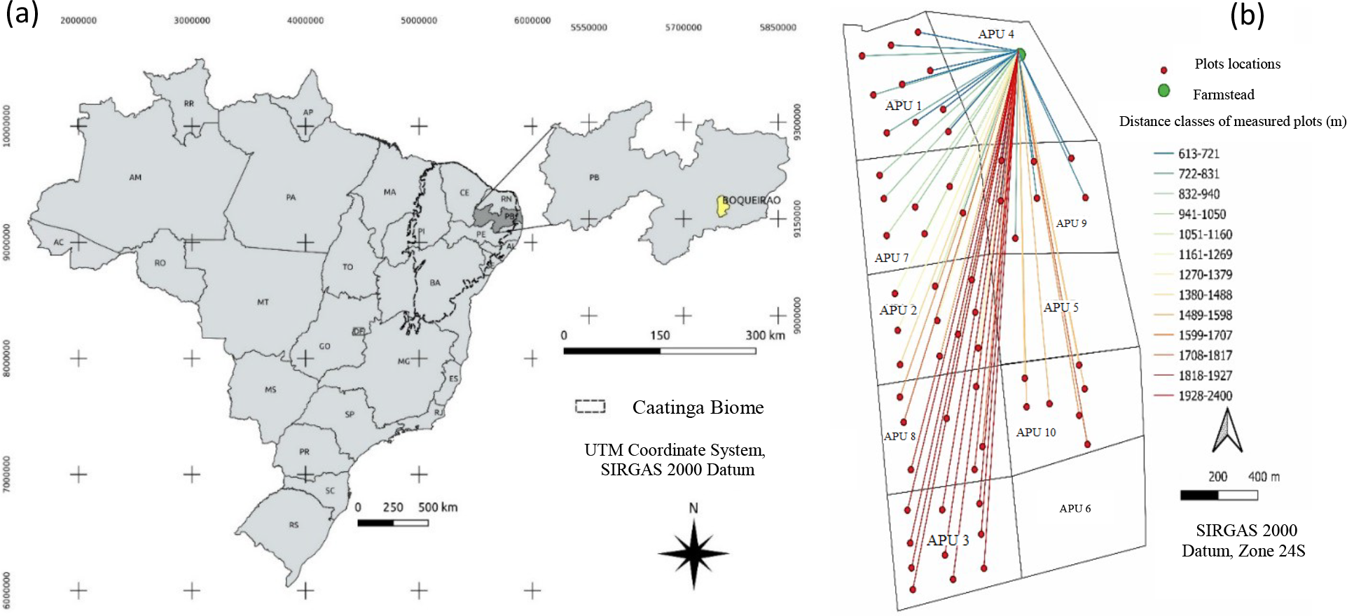
The study area is located in the municipality of Boqueirão, in Paraíba state (PB), Brazil, and comprises approximately 300 hectares of seasonally dry tropical forest under timber forest management (Figure 1).

(a) Geographic location of the forest management area studied; (b) spatial distribution of Annual Production Units (APUs), sampling plots and Euclidean distances between plot centers and the farmstead (meters), grouped into distance classes.
The study area is located in the "Crystalline Caatinga," the predominant type of SDTF within the Caatinga domain. The vegetation is physiognomically classified as shrub-arboreal, with an average height of 7 m and mean diameter at breast eight (DBH) of 15 cm. The most frequent morphospecies recorded were Aspidosperma pyrifolium Mart., Poincianella pyramidalis (Tul.) L.P.Queiroz, Croton sonderianus Muell. Arg, Bauhinia cheilantha (Bong.) Steud., Manihot glaziovii Muell. Arg., Myracrodruon urundeuva Allem., and Jatropha molíssima. Among these, A. pyrifolium, P. pyramidalis, M. urundeuva, B. cheilantha, and C. sonderianus exhibited the highest importance value indexes (QUEIROZ et al., 2006).
According to the exploratory inventory conducted for the forest management plan under evaluation, the initial woody biomass volume was estimated at 38.7 m3 ha⁻1, with a mean annual volume increment of 0.98 m3 ha⁻1 year⁻1 (PAREYN et al., 2020). Although pre-harvest basal area data were not available for the study area, a previous study carried out in Boqueirão (PB), in a forest classified as being in an intermediate successional stage, recorded a basal area of 6.1 m2 ha⁻1 (QUEIROZ et al., 2006). In the 2019 inventory conducted in the present study area, mean basal area was 2.5 m2 ha⁻1. This estimate excludes remnant individuals and was obtained from plots with recovery periods ranging from 11 to 17 years following harvesting. The forest management plan adopted a 10-year cutting cycle, resulting in the subdivision of the area into 10 Annual Production Units (APUs). Of these, seven APUs were harvested using a simple coppicing system and were included in the analyses (Table 1).
Annual Production Units (APUs) evaluated, including harvest year, effective woody biomass recovery time (ERT), and number of plots used in the analyses in Boqueirão, Paraíba, Brazil.
Climate and precipitation
The study area is located in the Brazilian semi-arid zone and is classified as climate type Bsh. Mean annual precipitation is 467 mm, with high interannual variability and a marked concentration between February and May (ALVARES et al., 2013).
Mean precipitation during the recovery period of each APU was estimated using data from a rainfall station located 9 km from the study area (station 735124, Latitude -7.5283, Longitude -35.9997), obtained from the HidroWeb portal (ANA, 2020). Annual precipitation varied substantially between 2002 and 2019, with an overall mean of 444 mm. For each APU, cumulative (Pac) and mean annual precipitation (Pma) APU (Table 2) were calculated based on the effective recovery time, defined as the interval between the year following woody vegetation cutting and the year 2019.
Effective recovery time and precipitation metrics for each Annual Production Unit (APU), calculated over the post-harvest recovery period in Boqueirão, Paraíba, Brazil.
Mean soil bulk density and depth
Soil bulk density was determined from samples collected in trenches excavated at the center of each plot. To capture vertical variability along the soil profile, samples were collected from successive depth intervals (0-10, 10-30, 30-50, 50-70, 70-90, and >90 cm), depending on the effective depth of each soil profile. Undisturbed samples were obtained using a volumetric cylinder (118.79 cm3) and oven-dried to constant mass. Bulk density for each layer was calculated following Van Lier (2019):
where p is soil bulk density (g.cm-3), ms the dry soil mass (g), and V the cylinder volume (cm-3).
Although bulk density was measured for each depth interval, mean bulk density across the entire soil profile was used in the statistical analyses. This approach was adopted because soil profiles varied in depth among plots and because mean bulk density showed strong correlations with bulk density measured in the 0-10 cm and 10-30 cm layers (Spearman correlation coefficients > 0.60).
Effective soil depth (cm) was measured using a tape measure graduated at 10 cm intervals and defined as the vertical distance from the soil surface to the occurrence of a restrictive layer or lithic contact.
Plot slope and elevation
Plot-level elevation and slope were derived from a Digital Elevation Model (DEM) obtained from the Shuttle Radar Topography Mission (SRTM) (USGS, 2018) with a spatial resolution of 30 m. DEM processing and data extraction were performed using QGIS software. Elevation (m) and slope (degrees) values were extracted for the center of each plot.
Indirect measures of anthropogenic disturbance
Anthropogenic disturbance was quantified using indirect indicators rather than direct measurements, since these disturbances are difficult to measure reliably at the plot scale (RIBEIRO et al., 2015).
Livestock grazing intensity was estimated by collecting dung in four systematically established 9 m2 (3 × 3 m) subplots centered on the soil sampling trench. Dung from cattle, goats, sheep, horses, and donkeys was collected, oven-dried, and weighed using a digital scale (MARINHO et al., 2016). Measurements from the four subplots were extrapolated to express grazing intensity in kilograms per hectare (kg ha⁻1).
In addition, the Euclidean distance from the center of each plot to the farmstead was calculated using the "Distance to Nearest Hub (Line to Hub)" algorithm implemented in QGIS software.
Basal area sampling
Basal area was assessed in 2019 by measuring all arboreal-shrub individuals with circumference at breast height (CBH) > 6.0 cm, following the guidelines of the Caatinga Forest Management Network. Measurements were conducted in seven randomly distributed 400 m2 plots within each APU. Circumference values were converted to DBH using the formula DBH = CBH / 3.1416.
Individual basal area was calculated from DBH values, or from equivalent DBH values for multi-stemmed individuals. Individual areas were summed to obtain total basal area (m2 400 m⁻2) and then scaled to express basal area per hectare (m2 ha⁻1).
Remnant individuals were excluded from basal area calculations because the simple coppicing system adopted in Caatinga forest management typically removes 70-100% of the woody biomass. Under this system, legally protected species, those not used for firewood or charcoal, and species providing non-timber products such as fruit or shade for livestock are retained (PAREYN et al., 2020).
Accordingly, only individuals originating from coppice resprouting or seed regeneration were included. Coppice resprouts were identified by visible cutting scars, while remnant individuals were identified based on diameter and height values that were markedly higher than the stand average.
Statistical analysis
Data analysis was conducted in two stages. First, differences in productivity among APUs were evaluated by subjecting basal area estimates (m2 ha⁻1) to analysis of variance (ANOVA), with APU treated as a categorical explanatory variable. Because model residuals met the assumption of normality, mean basal area values were compared using Tukey’s post hoc test (p < 0.05). In the second stage, relationships between basal area (response variable, Y) and continuous predictor variables (Xs) mean annual rainfall, elevation, slope, soil depth, mean soil bulk density, distance to the farmstead, and grazing indicator-were examined using general linear models (GLM). This approach is appropriate for modeling linear relationships involving continuous response variables with normally distributed errors (OLIVEIRA, 2024), a condition satisfied by our data.
Multicollinearity among predictors was assessed using the Variance Inflation Factor (VIF). Only predictors with VIF values < 4 were retained (RIBEIRO et al., 2015; MAIA et al., 2020). Elevation exhibited a VIF of 4.38 and was therefore excluded from subsequent analyses.
Model selection followed the principle of parsimony through comparison of nested models. Models were evaluated based on the significance of the F-statistic, the coefficient of determination (R2), and the number of parameters, with preference given to models that achieved a significant fit with higher explanatory power and fewer predictors (OLIVEIRA, 2024). The analysis followed these steps: 1) fitting the full model containing all predictor variables and estimating their VIFs; 2) removing elevation due to collinearity; 3) refitting the model and evaluating the F-statistic, R2, and number of parameters; and 4) sequentially removing non-significant predictors (mean soil bulk density, grazing indicator, and soil depth, in this order).
The final model was evaluated for the significance of the retained parameters (variance partitioning analysis) and for residual normality using the Shapiro-Wilk test (p < 0.05).
To satisfy the assumption of linearity between predictors and the response variables, all variables were log-transformed (log10) prior to model fitting (GOTELLI; ELLISON, 2011).
RESULTS AND DISCUSSION
Mean basal area (m2 ha⁻1) differed significantly among the APUs (F= 3.2685; p = 0.0099). In particular, APU 3 exhibited significantly higher basal area values than APU 9 (p =0.009545) (Figure 2).

Tukey’s post hoc comparison (p < 0.05) of mean basal area (m2.ha-1) across annual production units (APU1, APU2, APU3, APU10, APU7, APU8, APU9). APUs sharing the same letter do not differ significantly.
Variation in basal area and productivity was best explained by mean annual precipitation and distance from the plots to the farmstead (F = 3.49; p = 0.02303). Despite being statistically significant, the minimum adequate model explained a relatively small proportion of variance, with an adjusted R2 of 0.13 (Table 3).
ANOVA results for the minimum adequate model explaining basal area variation among APUs in Boqueirão, Paraíba, Brazil.
Although the explanatory power of the selected model was limited (13%), this result is consistent with previous studies conducted in Caatinga STDFs, which report a wide range of R2 values depending on the variables considered and the spatial scale of the analysis.
For example, Maia et al. (2020) found that models incorporating soil and climatic attributes explained between 18% and 21% of aboveground woody biomass variation. Conversely, Souza et al. (2019), incorporating land-use intensity, soil fertility, and rainfall variables, reported models explaining up to 62% of biomass recovery variance.
This variability in the inherent complex nature of biomass recovery in Caatinga SDTFs, which are driven by interacting environmental and anthropogenic factors, whose effects are often difficult to understand (SOUZA et al., 2019; PAREYN et al., 2020), particularly at local scales (MAIA et al., 2020).
In addition, the present study was designed as an exploratory case study. Rather than producing a highly predictive model, the aim was to identify key environmental and anthropogenic gradients potentially associated with post-harvest basal area recovery, thereby supporting hypothesis generation and guiding future research. Consequently, the interpretation of results is necessarily constrained by the specific local conditions of the study area.
Within this context, basal area tended to increase with higher mean annual precipitation and with increasing distance from the farmstead (Table 4).
Parameter estimates, standard errors, t-values, p-values, and confidence intervals obtained from the minimum adequate linear model.
Plots located in APUs receiving higher mean annual precipitation and those situated further from the farmstead exhibited higher basal area recovery. This pattern explains the significantly greater basal area observed in APU 3 compared with APU 9.
Among APUs with similar precipitation regimes, such as APUs 1, 2, and 3, distance from the farmstead emerged as a more influential factor, helping to explain similarities and differences in basal area recovery among these units.
The positive effect of mean annual precipitation on basal area recovery (β = 3.50719; p = 0.007612) reinforces rainfall as a primary driver of woody biomass recovery following simple coppicing, supporting the expectation of a positive relationship between increased post-intervention precipitation and managed vegetation growth rates.
Numerous studies in Caatinga SDTFs have documented strong positive relationships between precipitation and biomass accumulation after disturbance (RITO et al., 2017; SOUZA et al., 2019).
Salimon and Anderson (2018) analyzed long-term productivity data from 40 Caatinga SDTF sites and found that precipitation variability explained more than half of the observed variation in biomass productivity, with a 65% decrease in rainfall causing a 25% productivity loss in a single year.
Similarly, Pareyn et al. (2020) showed that rainfall was the primary determinant of biomass increment following coppicing, explaining nearly half of the observed variability across sites.
In addition to climatic control, distance from the farmstead exerted a significant positive effect on basal area recovery (β = 0.30100; p = 0.007612).
Areas closer to households and rural infrastructure (e.g., corrals) are typically exposed to higher chronic anthropogenic disturbance, including biomass extraction and livestock browsing, which limit regeneration capacity and productivity. This proximity is also linked to degradation of soil attributes essential for ecosystem functioning (RIBEIRO et al., 2015; SCHULZ et al., 2016; SFAIR et al., 2018).
Reduced woody biomass accumulation in these areas likely reflects adaptive resistance strategies developed by target species under altered environmental conditions. These strategies include reduced allocation to aboveground biomass and increased investment of photoassimilates in root system development, enhancing resource conservation. These responses not only constrain aboveground productivity but also modify individual architecture and overall forest stand structure (SANTANA; ENCINAS, 2016).
In this study, distance to the farmstead captures the spatial dimension of forest resource use and likely integrates the cumulative effects of long-term extraction and grazing. Areas closer to the farmstead are more accessible and generally less steep, conditions that facilitate anthropogenic use. We argue that more intense disturbance near the farmstead likely counteracted the positive effects that longer recovery periods and higher mean annual precipitation would otherwise exert on forest regeneration. This effect is particularly evident when comparing basal area recovery in APU 3 with that in APUs 1 and 2.
This interpretation is supported by previous studies. In extensive ranching systems in the Caatinga, livestock tend to graze more frequently in previously disturbed, degraded, or open areas. Animals preferentially forage near residences or corrals and in areas where vegetation structure has been altered to increase accessibility (JAMELLI; BERNARD; MELO, 2021).
Nevertheless, the absence of a detectable effect of the grazing indicator warrants discussion. Because grazing pressure was estimated using spot measurements of dung biomass an operationally simple field indicator it may not adequately reflect cumulative grazing intensity over time, leading to an underestimation of historical pressure. Future studies should therefore incorporate complementary indicators capable of capturing long-term grazing dynamics.
Accurate quantification of disturbance is essential for interpreting biomass recovery patterns. Caatinga trees and shrubs subjected to simple coppicing followed by intense grazing accumulate substantially less aboveground biomass than undisturbed individuals. While foliar biomass shows relatively higher resilience, stem biomass production declines markedly once livestock access resprouting vegetation (HARDESTY; BOX, 1988), ultimately reducing stand basal area (MARINHO et al., 2016).
The lack of significant effects of soil attributes such as effective depth and mean bulk density suggests that other edaphic factors play a more prominent role. In particular, particle size distribution and its influence on soil water retention capacity may be more relevant. Clay-rich soils typically retain more moisture due to their higher surface area, supporting greater vegetation productivity (QUEIROZ et al., 2020). Empirical evidence from the Caatinga indicates that clayey or organic-matter-rich soils promote greater species richness, regeneration potential, and biomass accumulation (MAIA et al., 2020; SOUZA et al., 2020).
With respect to soil depth, woody species in Caatinga SDTFs generally exhibit shallow and laterally homogeneous root systems, with approximately 65% of root biomass concentrated within the upper 30 cm of soil (COSTA et al., 2014). Although deeper water uptake occurs, moisture stored in the 0-20 cm soil layer can supply up to 80% of atmospheric evaporative demand (PINHEIRO et al., 2016; QUEIROZ et al., 2020).
Despite the overall trends identified by the model, it does not fully explain the lack of statistical differences in mean basal area between plots in APUs 2, 10, 7, and 8, and those in APU 9. Although plots in the former group experienced slightly higher mean annual precipitation and were located further from the farmstead, these factors alone were insufficient to generate significantly higher basal area values.
These results suggest that additional, unmeasured variables contribute to post-harvest forest regeneration. Potential drivers include spatial variation in soil texture and water-holding capacity (QUEIROZ et al., 2020), differences in species composition and resistance to chronic anthropogenic disturbance (SFAIR et al., 2018; PINHO et al., 2019), and the intensity and persistence of historical disturbance regimes (ARAÚJO FILHO et al., 2018; SOUZA et al., 2019).
Studies across the Caatinga domain consistently demonstrate that clay-rich or organic-matter-rich soils retain more moisture and support greater species richness and biomass production. Consequently, woody species responses to regional precipitation regimes are strongly mediated by the local spatial distribution of soil water availability (PINHO et al., 2019; SOUZA et al., 2020).
In this context, Maia et al. (2020) showed that soil texture modulates the effects of precipitation on species richness and aboveground biomass. Their results indicate that sites combining higher water availability with clay-rich soils exhibited both greater biomass accumulation and higher species richness.
Structurally and floristically simplified forest ecosystems in the Caatinga often shaped by long-term anthropogenic intervention are often dominated by a limited number of disturbance-tolerant species. These species may form nearly monodominant stands characterized by low biomass productivity (RIBEIRO et al., 2015; RITO et al., 2017; SCHULZ et al., 2019).
Evidence from functional ecology studies reinforces this pattern. Ribeiro et al. (2019), demonstrated that chronic anthropogenic disturbances act as ecological filters in Caatinga woody plant communities, reshaping functional composition and diversity through the selection of specific traits, such as low wood density. These disturbances reduce stand biomass and favor disturbance-adapted species associated with rapid resource acquisition strategies, while limiting the occurrence of acquisitive species.
Collectively, this evidence supports the hypothesis that chronic anthropogenic disturbances constrain biomass production and accumulation in Caatinga SDTFs, particularly under low mean annual precipitation conditions (<700 mm year⁻1), where vegetation is subject to co-limitation by drought stress and human disturbance (RIBEIRO et al., 2015; RITO et al., 2017; SOUZA et al., 2019).
These findings highlight the importance of local-scale interactions between anthropogenic activities and environmental attributes in determining woody vegetation responses and productivity (RITO et al., 2017; SOUZA et al., 2019). Accordingly, basal area recovery cannot be attributed to single drives such as precipitation or disturbance alone, but rather emerges from complex interactions among edaphoclimatic, ecological, and anthropogenic factors.
The results of this study have direct implications for forest management planning in the Caatinga, particularly following the enactment of Resolution No. 507/2024 of the National Environmental Council, which established new guidelines for environmental licensing. Under this regulation, managed forest areas may be incorporated into silvopastoral systems, allowing cattle grazing in areas subjected to simple coppicing, provided that technical carrying capacity criteria are respected.
Our findings suggest, however, that the management regime permitted by Resolution No. 507/2024 may compromise forest regeneration, reduce woody biomass productivity, and undermine the conservation objectives of managed forests.
Importantly, forest responses to harvesting interventions and subsequent grazing regimes are expected to vary according to local mean annual precipitation. Rainfall across the Caatinga is highly heterogeneous, both spatially and temporally, generating distinct precipitation zones that differ in vegetation growth patterns and responses to anthropogenic disturbance (PAREYN et al., 2020). In these contexts, regeneration impairment is likely more pronounced in areas experiencing lower rainfall (RITO et al., 2017).
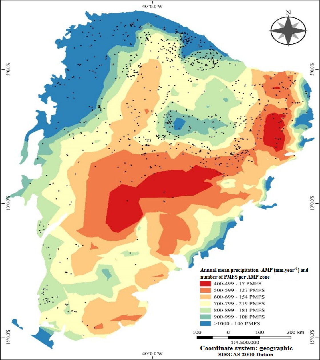
In this regard, analysis of the spatial distribution of Sustainable Forest Management Plans (PMFS) implemented between 1988 and 2018 reveals that regions with mean annual precipitation up to 700 mm year⁻1 accounted for 298 of the 952 PMFS implemented during this period (Figure 3). These areas also represent approximately 43% of the total Caatinga biome, underscoring their spatial significance and highlighting the need to carefully consider regeneration constraints when implementing forest management strategies in drier regions (Figure 3).
Sustainable Forest Management Plans (PMFS) implemented in the Caatinga between 1988 and 2018 (black dots on the map), grouped by mean annual precipitation zones (mm year⁻1).
CONCLUSIONS
The results of this case study indicate that woody biomass recovery in Caatinga Seasonally Dry Tropical Forests following forest management is governed by complex interactions among multiple edaphoclimatic and ecological factors, the intensity of anthropogenic interventions, and the spatial variability of these drivers at the management unit scale. Our findings provide additional evidence that post-harvest recovery depends not only on local mean annual precipitation but also on the anthropogenic use regimes imposed after forest harvesting.
Although domestic livestock grazing did not emerge as a significant predictor in the best-fitting model, we hypothesize that grazing and other chronic anthropogenic disturbances occurring after harvesting may impair regeneration and reduce the future productivity of Caatinga seasonally dry forests, particularly in drier regions (e.g., <700 mm year⁻1). This hypothesis warrants further investigation to allow a more comprehensive assessment of these interactions.
In addition, we propose that local variation in soil particle size distribution and water retention capacity may play an important role in shaping the productivity patterns of managed Caatinga SDTFs. Thus, while recent studies have advanced understanding of how biomass productivity responds to regional gradients in mean annual precipitation, future research integrating soil texture and water retention attributes will be essential to better quantify spatial variation in forest regeneration and productivity across the Caatinga.
ACKNOWLEDGMENTS
We thank the Brazilian Coordination for the Improvement of Higher Education Personnel (Coordenação de Aperfeiçoamento de Pessoal de Nível Superior - CAPES) for the financial support provided (Funding Code 001). We thank APNE - Associação Plantas do Nordeste, especially Frans Pareyn, Elmo C. Gomes, Marinho and José Luis for their logistical and technical support in carrying out the fieldwork. We also thank Maria Inês Heraclio do Rego and Jerônimo Heraclio for allowing access to the management plan at Fazenda Minas, in Boqueirão, Paraíba. We are also grateful to the reviewers for their valuable comments and suggestions, which contributed to improving the final version of this manuscript.
Data Availability:
The data that support the findings of this study can be made available, upon reasonable request, from the corresponding author.
REFERENCES
- ALVARES, C. A. et al. Köppen’s climate classification map for Brazil. Meteorologische Zeitschrift, 22: 711-728, 2013.
-
ANA - Agência Nacional das Águas. Sistema Nacional sobre Recursos Hídricos (SNIRH): Portal HidroWeb, 2020. Available at: https://www.snirh.gov.br/hidroweb/serieshistoricas Access on: Sep. 7, 2020.
» https://www.snirh.gov.br/hidroweb/serieshistoricas - ARAÚJO FILHO, R. N. et al. Recovery of carbon stocks in deforested caatinga dry forest soils requires at least 60 years. Forest Ecology and Management, 407: 210-220, 2018.
- BALVANERA, P.; QUIJAS, S.; PÉREZ-JIMÉNEZ, A. Distribution Patterns of Tropical Dry Forest Trees Along a Mesoscale Water Availability Gradient. Biotropica, 43: 414-422, 2011.
- COELHO JUNIOR, L. M. et al. Regional concentration of the gross production value of firewood in Paraíba. Floresta e Ambiente, 26: 20170887, 2019.
- COSTA, T. L. et al. Root and shoot biomasses in the tropical dry forest of semi-arid Northeast Brazil. Plant and Soil, 378: 113-123, 2014.
- GOTELLI, N. J.; ELLISON, A. M. Princípios de estatística em ecologia 1. ed. São Paulo, SP: ArtMed, 2011. 527 p.
- HARDESTY, L. H.; BOX, T. W. Defoliation Impacts on Coppicing Browse Species in Northeast Brazil. Journal of Range Management, 41: 66, 1988.
- JAMELLI, D.; BERNARD, E.; MELO, F. P. L. Habitat use and feeding behavior of domestic free-ranging goats in a seasonal tropical dry forest. Journal of Arid Environments, 190: 104532, 2021.
- MAIA, V. A. et al. Interactions between climate and soil shape tree community assembly and above-ground woody biomass of tropical dry forests. Forest Ecology and Management, 474: 118348, 2020.
- MARINHO, F. P. et al. Effects of past and present land use on vegetation cover and regeneration in a tropical dryland forest. Journal of Arid Environments, 132: 26-33, 2016.
-
OLIVEIRA, A. A. Princípios de Planejamento e Análise de Dados em Ecologia 2024. Available at: http://labtrop.ib.usp.br/doku.php?id=cursos:planeco:start Accessed on: Aug 1, 2024.
» http://labtrop.ib.usp.br/doku.php?id=cursos:planeco:start - PAREYN, F. G. C. et al. What controls post-harvest growth rates in the caatinga forest? Agricultural and Forest Meteorology, 284: 107906, 2020.
- PINHEIRO, E. A. R. et al. Importance of soil-water to the Caatinga biome, Brazil. Ecohydrology, 9: 1313-1327, 2016.
- PINHO, B. X. et al. Plant functional assembly is mediated by rainfall and soil conditions in a seasonally dry tropical forest. Basic and Applied Ecology, 40: 1-11, 2019.
- QUEIROZ, J. A. et al. Análise da Estrutura Fitossociológica da Serra do Monte, Boqueirão, Paraíba. Revista de Biologia e Ciências da Terra, 6: 251-259, 2006.
- QUEIROZ, M. G. et al. Spatial and temporal dynamics of soil moisture for surfaces with a change in land use in the semi-arid region of Brazil. Catena, 188: 104457, 2020.
- RIBEIRO, E. M. S. et al. Chronic anthropogenic disturbance drives the biological impoverishment of the Brazilian Caatinga vegetation. Journal of Applied Ecology, 52: 611-620, 2015.
- RIBEIRO, E. M. S. et al. Functional diversity and composition of Caatinga woody flora are negatively impacted by chronic anthropogenic disturbance. Journal of Ecology, 107: 2291-2302, 2019.
- RITO, K. F. et al. Precipitation mediates the effect of human disturbance on the Brazilian Caatinga vegetation. Journal of Ecology, 105: 828-838, 2017.
- SALIMON, C.; ANDERSON, L. How strong is the relationship between rainfall variability and caatinga productivity? A case study under a changing climate. Anais da Academia Brasileira de Ciências, 90: 2121-2127, 2018.
- SANTANA, O. A.; ENCINAS, J. I. Dendrophysiological plant strategies of Poincianella pyramidalis (Tul.) L.P. Queiroz after wood herbivory in semiarid region of Paraíba-Brazil. Acta Scientiarum - Biological Sciences, 8: 179-186, 2016.
- SCHULZ, K. et al. Grazing deteriorates the soil carbon stocks of Caatinga forest ecosystems in Brazil. Forest Ecology and Management, 367: 62-70, 2016.
- SCHULZ, K. et al. Grazing reduces plant species diversity of Caatinga dry forests in northeastern Brazil. Applied Vegetation Science, 22: 348-359, 2019.
- SFAIR, J. C. et al. Chronic human disturbance affects plant trait distribution in a seasonally dry tropical forest. Environmental Research Letters, 13: 025005, 2018.
- SOUZA, D. G. et al. Multiple drivers of aboveground biomass in a human-modified landscape of the Caatinga dry forest. Forest Ecology and Management, 435: 57-65, 2019.
- SOUZA, C. R. et al. Small-scale edaphic heterogeneity as a floristic-structural complexity driver in Seasonally Dry Tropical Forests tree communities. Journal of Forestry Research, 31: 2347-2357, 2020.
-
USGS - Unitade States Geological Survey. USGS EROS Archive - Digital Elevation - Shuttle Radar Topography Mission (SRTM) 1 Arc-Second Global 2018. Available at: https://doi.org/10.5066/F7PR7TFT Access on: Sep. 8, 2020.
» https://doi.org/10.5066/F7PR7TFT - VAN LIER, Q. J. Disponibilidade de água às plantas. In: VAN LIER, Q. J. (Ed.). Física do solo Viçosa, MG: Sociedade Brasileira de Ciência do Solo, 2019. s/v, cap. 8, p. 283-297.
Edited by
-
Editor in Chief:
Aurélio Paes Barros Júnior
-
Section Editor:
Poliana Coqueiro Dias