Abstract
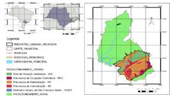
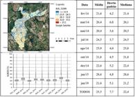
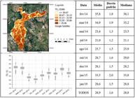
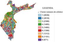
Global warming makes urban fabric benchmarking necessary for the development of policies that promote urban heat resilience. This research is aimed at identifying urban fabric patterns, which can promote the negative feedback of the urban climate system naturally. The method includes the use of Landsat-8 satellite images to estimate and to map the land surface temperatures and its spectral features (albedo, emissivity, fraction vegetation cover and normalised difference moisture index), the data integration at a cellular georeferenced space, correlation, autocorrelation and clusters analyses and the identification of local climate zones. The study area is São José dos Campos, SP, Brazil, where local climate zone 3, where compact, small buildings predominate. The biggest difference in surface temperature was 12 °C and was detected between areas with permeable and shaded surfaces, associated with the presence of trees, and fully impermeable surfaces with large buildings. The analyses showed the spatial dependence of surface temperature, despite seasonal variability, indicating that it can be used to identify factors which influence feedback processes of the urban climate system, which can help in the development of policies to promote urban adaptation and heat resilience.
Keywords:
Urban policy; Land surface temperature; Local climate zones; Benchmarking

 Thumbnail
 Thumbnail
 Thumbnail
 Thumbnail
 Thumbnail
 Thumbnail
 Thumbnail
 Thumbnail
 Thumbnail
 Thumbnail
 Thumbnail
 Thumbnail
 Thumbnail
 Thumbnail
 Thumbnail
 Thumbnail
 Thumbnail
 Thumbnail
 Thumbnail
 Thumbnail
 Thumbnail
 Thumbnail
 Thumbnail
 Thumbnail
 Thumbnail
 Thumbnail
 Thumbnail
 Thumbnail
 Thumbnail
 Thumbnail
 Fonte: adaptado de
  Fonte: adaptado de Instituto Brasileiro de Geografia e Estatística (
 Fonte: adaptado de
  Fonte: adaptado de


