 Use of GPR - Ground Penetration Radar for detecting underground water distribution networks - case study: technical cadastre of COMPESA - Companhia Pernambucana de Saneamento
Abstract:
This research study deals with improving the network cadastre of a sanitation company through the inclusion of three-dimensional data in the geographic database, which can represent the embryo of a 3D cadastre. To investigate the collection and inclusion of the depth of underground pipelines, a methodology was tested for obtaining 3D data using the Ground Penetrating Radar - GPR, regarding the triplication project of highway BR-232, located in Recife-PE. The study noted that the GPR survey also had some limitations, due to the pedological, geological and topographic characteristics of the site, and that the electromagnetic properties of the soil and minerals also need consideration, as well as the characteristics of the terrain to carry out the displacement of the equipment on the ground. The results demonstrated that, despite the limitations found in the GPR survey, where there were sections in which it was not possible to identify the pipelines, for the application analyzed and for the tested study area, the use of georadar in obtaining pipeline depth data was considered satisfactory.
Keywords:
3D Cadastre; Ground Penetration Radar - GPR; Cadastre of water supply networks
1. Introduction
Issues related to land administration are completely linked to the application of the cadastre. In general terms, this cadastre deals with the relationships between people and land, highlighting physical/positional, descriptive and legal characteristics, among others. The technical cadastres of service concessionaires are structured to describe the elements of their specific networks, relating them to their main characteristics (attributes), as well as associating these elements with the territorial possession situation that defines the rights, restrictions and responsibilities applicable to each parcel.
The cadastral community understands that the problem of most of the world’s population not having access to adequate land administration systems can be strongly related to the data collection process, where the use of highly accurate spatial information collection methods, that are expensive and time-consuming is over-valued. To overcome this, innovative spatial data collection methods must be employed (Rahmatizadeh et al. 2018).
To overcome this problem, the World Bank, together with the International Federation of Geometers - FIG (Fédération Internationale des Géomètres) suggest a Fit-For-Purpose land administration approach, allowing appropriate territorial administration systems to be built in a relatively short time, at affordable costs and with the option of updating when necessary (Lemmen et al. 2015).
Thus, defining data acquisition methods that are appropriate to the need of implementing or updating rights, restrictions and responsibilities related to land and properties, is essential for implementing land administration tools throughout the world.
Considering the Fit-For-Purpose approach and given the difficulties encountered in implementing land management, each government or institution may use a different method of collecting spatial data to achieve its goals and objectives of territorial administration, that is, to adapt to their specific purposes.
In addition to bi-dimensional territorial management, with the evolution of urban development a new issue arises: the increased demand for rights, restrictions and responsibilities (RRRs) of land and 3D properties. This occurs due to the increase in population density and, consequently, the expansion in the number of properties with more than one floor (vertical expansion of cities).
This fact also applies to tunnels, cables and ducts for infrastructure networks (water, electricity, telephone, gas, fiber optic cables, cable TV), hence knowledge about the behavior of these networks is extremely important for planning infrastructure projects, future installations of public equipment and new subdivisions, in addition to contributing to ordering the use of subsoil (Souza 2011).
As tools to help meet these demands, new procedures for acquiring, storing, processing and representing spatial data have been developed, resulting in new possibilities regarding the use of geospatial information, including the generation of models of three-dimensional (3D) objects.
As an alternative for acquiring information relating to the 3rd dimension (in this case, depth), there is the Ground Penetrating Radar - GPR, also known as ground sounding radar or georadar, which is characterized by being a geophysical tool with a wide range of applications.
Over the past 30 years, GPR has been successfully used to assist in solving problems in a variety of fields, such as archaeology, environmental site characterization, glaciology, hydrology, unexploded landmine/ammunition detection, sedimentology, and structural geology (Priyanka et al. 2022).
GPR has also been employed to detect underground infrastructure and can be used for applications such as subsurface stratigraphy, archeology and specific examinations (Senthil et al., 2021). According to Bachiri et al. (2021), research shows that Ground Penetrating Radar (GPR) can be an effective and efficient way to map buried pipeline systems.
In this sense, Cadastre research was also influenced by these issues, which has motivated researchers to verify the demands and impacts on the cadastral system of the so-called 3D Cadastre (Souza 2011).
As an example of institutions with a high demand for the 3D cadastre we have the public service concessionaires, such as Companhia Pernambucana de Saneamento - COMPESA, which has a 2D cadastre derived from information from archives, construction management and other sources. Regarding cadastres of infrastructure networks, more specifically cadastres of water and sewage networks, it is important to consider the inclusion of the third dimension to better characterize underground networks.
In this context, the research tested the hypothesis that the use of cadastral data in three dimensions makes it possible to provide more comprehensive information on utilities networks, such as the depth at which the network is located, reducing the amount of exploratory drilling and consequently the damage caused to the network.
Considering the studies cited in the literature review, the aim of this work was to test the use of GPR surveys to collect data on the depth of pipelines, a variable that can be used as preliminary data for a 3D cadastre.
2. Material and Methods
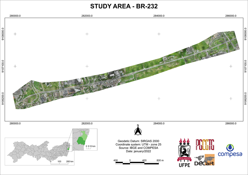
The research sought to test the application of GPR surveying to collect data of pipeline depths, as well as the inclusion of this data in the cadastre, as preliminary data for a 3D cadastre. The application was carried out in COMPESA’s technical cadastre, using a section of highway BR-232, in the city of Recife, as the study area. The choice of this study area was due to the demand for information on the existence and depth of pipelines, resulting from the project to triple highway BR-232. Figure 1 illustrates the location of this section.
Thus, having identified the need to characterize underground structures in a three-dimensional manner, and with GPR as one of the possibilities for collecting this data, a surveying was carried out to verify possible interferences in the triplication project of highway BR-232, resulting from the presence of the pipeline and COMPESA’s water network.
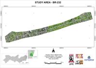
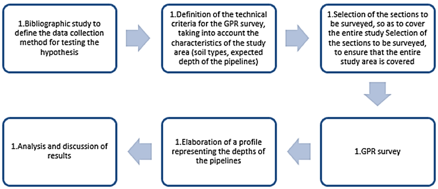
Figure 2 shows the stages in the development of the research, which will be detailed below.
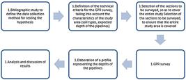
The files of the project initially planned for the triplication were compared with the networks already registered by Compesa, available in the technical cadastre sector. This analysis indicated the existence of underground pipes at the site (making it necessary to know their depth) and sections where the projection of the road (BR-232) to be triplicated was very close to the COMPESA’s pipeline.
Regarding the precision required for this survey, in sections where the underground pipes were closer to the surface and it was possible to identify them with high-frequency georadar antennas, the vertical positional precision - σV had to be ≤ 15 cm. In places where underground pipes were located at greater depths, requiring the use of lower frequency antennas, the vertical positional accuracy - σV had to be ≤ 25 cm.
The choice of vertical precision was based on the equipment’s precision (provided after consultation with some service providers), since when requiring better precision, it may not be achieved, which would make the survey unfeasible. In this way, the cadastre survey was based on the “Fit-For-Purpose” cadastre concept, adapting it to reality and needs.
The precision established for the depth meets the purpose of the survey, since in this case of large pipelines (with diameters of 1500 and 1200 mm), an uncertainty of up to 25 cm would not compromise decision-making regarding whether to relocate the pipes.
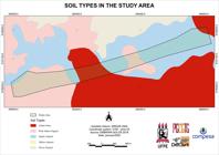
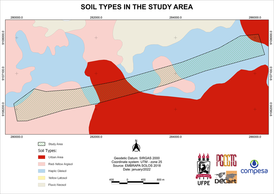
For this area, a map of soil types was also prepared (Figure 3), as the GPR survey is affected by soil types. The representation was based on the Agroecological Zoning of the State of Pernambuco (ZAPE) through the Map of recognition of low and medium soil intensity in the state of Pernambuco, produced by EMBRAPA (2018a). This map represents the spatial distribution of soils in the state of Pernambuco, according to the Brazilian Soil Classification System (EMBRAPA 2018b), on a scale of 1:100,000.
Figure 3 shows the following occurrences in the study area: Haplic Gleisol, Red Yellow Argisol and Urban area.
Gleisols comprise mineral hydromorphic soils, which have a gley horizon within 50 cm from the surface, or at a depth greater than 50 cm and less than or equal to 150 cm, as long as immediately below horizons A or E (with or without gleization), or a histic horizon with insufficient thickness to define the class of Organosols (Embrapa 2018).
The soils in this class are permanently or periodically saturated with water, unless artificially drained. The water remains internally stagnant or saturation occurs through lateral flow into the soil. In any circumstance, the water in the soil can elevate by capillary rise reaching the surface, that is, they are soils that are poorly or very poorly drained under natural conditions and that are occasionally formed in sloped areas under the influence of groundwater upwelling (Embrapa 2018).
Argisols are soils made up of mineral material, which are characterized by the presence of a low-activity clay textural B horizon, or high activity as long as it is combined with low base saturation or with an aluminum character. The textural B horizon (Bt) is located immediately below any type of surface horizon, except the histic one, without, however, meeting the requirements established to be classified in the classes of Luvisols, Planosols, Plintisols or Gleisols (Embrapa 2018).
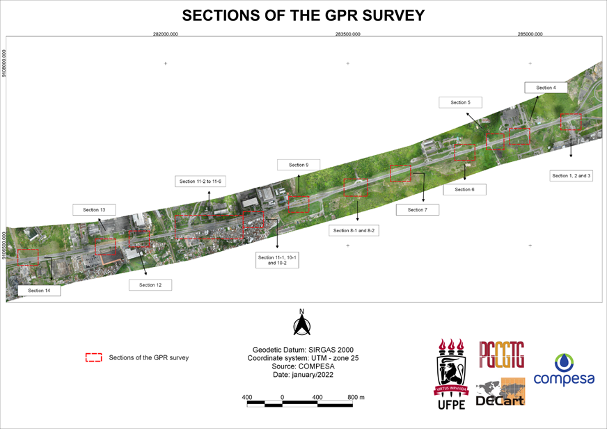
To begin the GPR mapping fieldwork, the specific non-continuous areas in which this mapping should be carried out were defined, so that the entire study section was still covered. These areas were called section 01 to section 14, as shown in Figure 4.
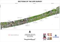
The definition of these survey sections by georadar considered the high cost of carrying out this survey in all sections of the pipeline (longitudinal and crossings along highway BR-232) and was because pipes commonly follow routing patterns without large planialtimetric oscillations. That is, considering small intervals between georadar sections, the pipes should not suffer large variations in depth. Furthermore, in this small interval, identifying the starting and ending points is sufficient to define its planimetric position.
When carrying out the field survey, GPR equipment equivalent to the SIR3000 system from GSSI (Geophysical Survey System Inc) was used, as well as a shielded antenna (not suffering interference from external noise) with a frequency of 400 MHz and a monostatic operating configuration. The survey was carried out by the company Plonus - Soluções em Engenharia e Meio Ambiente, supervised and managed within the scope of COMPESA by the author of the research.
Table 1 presents the relationship between the antenna frequency and the depth to be mapped for each application. The 400 mhz frequency was used in this research, following the equipment manufacturer’s guidelines for detecting utility networks.
The method of acquiring GPR images, called radargrams, made use of common offset, which consists of a constant distance technique where the geometry of the transmitting and receiving antennas remains fixed as the GPR moves at a constant speed.
Based on the probable position of the pipes, which were defined by the material available in the technical cadastre, GPR sections were defined and executed within each investigation area.
The visualization and processing of the data obtained were carried out using the RADAN 6.6 software, employing the tools of distance normalization, positioning correction, shadow remover, speed correction and gain adjustment.
Finally, complementing the mapping of underground pipes and aiming to have a complete base in case it becomes necessary to relocate the pipelines, a planialtimetric survey was also carried out along the pipelines, covering the elements that are part of the water supply system, roads, curbs, buildings, watercourses, drawing up of contour lines, etc.
3. Results and discussions
In this item, the results obtained in this research will be presented and discussed.
As a result of this stage, the data regarding the 3rd dimension was obtained (Z axis - depth) from the network cadastre, using the topographic survey associated with the mapping of underground pipelines using georadar. The mapping of underground pipelines by a non-destructive method using georadar, resulted in the radargrams of several points along the study section.
The GPR survey was carried out on the sections shown in Figure 3, and the results obtained are shown in Table 2, which indicates the depths of the points detected by the radar. Only in section 7 was this detection not possible, which can be explained by the characteristics of the soil, as will be detailed below.
The radargrams and analysis of all the sections are presented in Santos (2022). In this article, the results considered most significant are presented and discussed, to represent the methodology and results obtained.
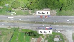
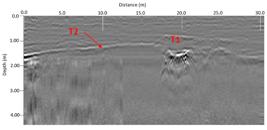
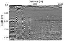
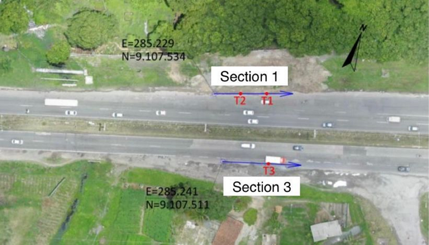
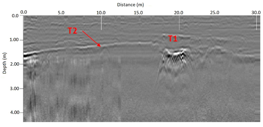
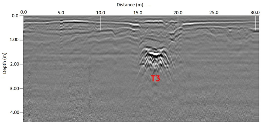
For sections 01 and 03, it appears that the spectral behavior of the responses obtained at points T1 and T3 are very similar, so that we can infer that the identified pipeline has the same characteristics, such as diameter and material, in addition to having the same depth, being then the same pipeline and consisting of a trajectory along highway BR-232. Figures 5 to 7 illustrate sections 01 and 03, exemplifying the results obtained.
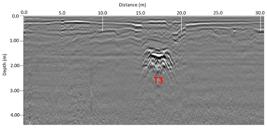
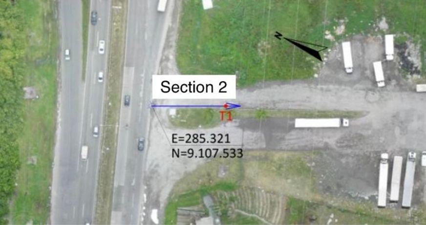
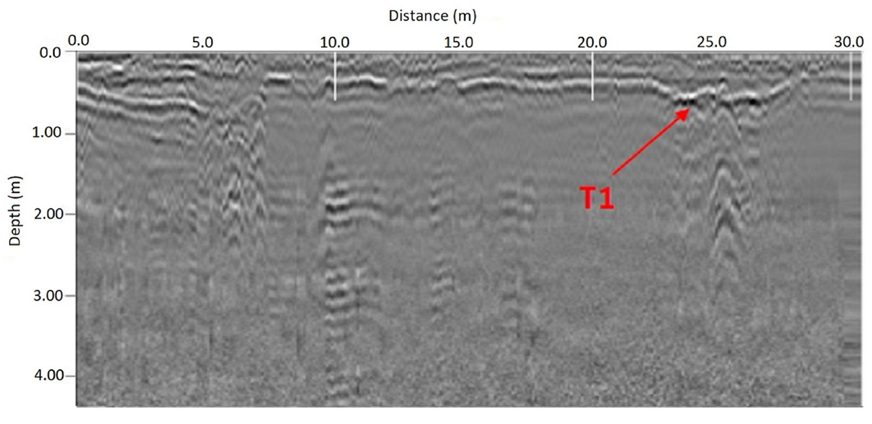
In relation to section 02, a pipeline hyperbola was identified, at a position 25.00m from the starting point of the section and at a depth of approximately 0.30m (T1).
However, despite the identification of point T1, the radargram of section 02 reveals an expected behavior for surveys carried out in places that have undergone a grounding process or soils with high humidity, resulting in an increase in electrical conductivity and consequently disturbances in the pulse. As a result, there is some interference in the radargram, making the interpretation of the patterns of the mapped features confusing.
This fact can be justified by the type of soil in which the GPR section in question is located. Section 02 is in the area covered by the Haplic Gleisol type, as seen in Figure 2, which is configured as a waterlogged soil, with excess humidity, as it is a hydromorphic soil. Figures 8 and 9 illustrate section 02 with the identified points and their respective radargram.
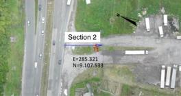
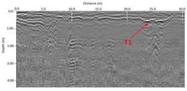
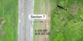
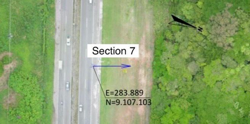
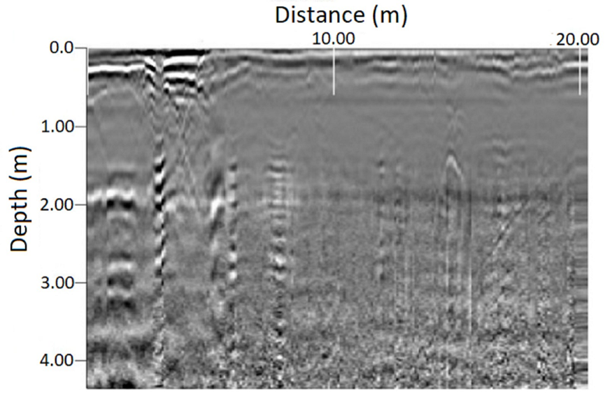
When analyzing Figures 10 and 11, the study observed that there were also sections of georadar mapping, in which the features of interest could not be identified.
The radargram in Figure 11 shows behavior that occurs in soils of landfill zones, with high humidity, extremely clayey soils, rich in iron minerals. This behavior can be justified by the occurrence of argisol-type soil in section 07.
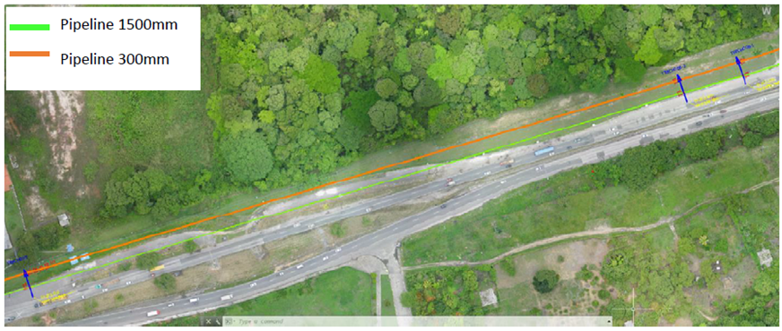
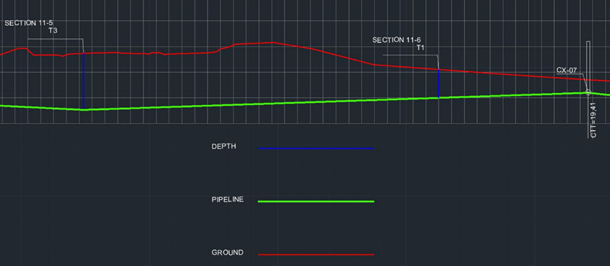
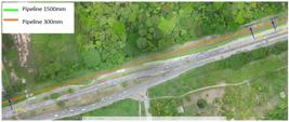
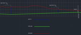
Finally, after completing the topographic survey of the area and having the cadastral planialtimetric information of the mapped section, a plan and profile were prepared indicating ground elevation, depth of pipeline, points identified by the GPR and boxes, which will be used to analyze the impact of the triplication of highway BR-232 over the network that makes up the area’s Water and Sanitation System, and a possible relocation project. Figures 12 and 13 illustrate, as examples, some georadar sections in the plan and one of the profile sections.
The data obtained is fundamental for evaluating the need for intervention in the network and subsequent development of the project, as both stages directly depend on the location and depth of the pipelines.
The need to verify the impact of the triplication project on COMPESA’s water network and to verify the cadastre of the pipelines is evident, considering the importance of the Tapacurá system, present on the site, which is responsible for approximately 36% of the volume of water distributed in the Metropolitan Region of Recife - RMR, covering the municipalities of Recife, São Lourenço da Mata, Camaragibe and Jaboatão dos Guararapes (Compesa 2016). It is essential that the highway R-232 triplication project is carried out without causing damage to this network, which could result in water waste and interruption of water supply to a large part of the population.
Subsequently, the data obtained from the GPR survey will integrate COMPESA’s technical cadastre, representing the three-dimensional characteristics inherent to the water supply network, and making the company’s cadastre increasingly more complete.
4. CONCLUSIONS
After understanding the structure of COMPESA’s technical cadastre system, a methodology was tested to obtain a three-dimensional component of the cadastre using GPR, with the objective of obtaining depths of underground pipelines (water network). This demonstrated the need and feasibility of using three-dimensional data in the technical cadastre, constituting information of great importance for the complete characterization of the cadastral object, whether above or below the ground, as well as for the necessary subsequent actions to be taken.
However, the study noted that the GPR survey also had some limitations, due to the pedological, geological and topographic characteristics of the site, and that the electromagnetic properties of the soil and minerals also need consideration, as well as the characteristics of the terrain to carry out the displacement of the equipment on the ground.
The results demonstrated that, despite the limitations found in the GPR survey, the use of georadar in obtaining pipeline depth data was considered satisfactory and met the needs. For the application analyzed and for the tested study area, only in section 07 was it not possible to detect the pipe, probably due to the type of soil. To get around these undesirable occurrences, tests could be carried out with new surveys in locations close to the section in which it was not possible to identify the underground interferences, to carry out the mapping in a soil with a slightly different state or characteristics. As for the vertical precision allowed (25cm), this was considered adequate for identifying the existing pipes in the study area. This was verified by comparing the data in the COMPESA register with the results of the survey.
Therefore, the conclusion is that the research met the proposed objectives, and the results are in line with recent research on the subject.
ACKNOWLEDGEMENT
This study was financed in part by the Coordenação de Aperfeiçoamento de Pessoal de Nível Superior - Brasil (CAPES) - Finance Code 001. The authors would also like to thank UFPE and COMPESA for their support.
REFERENCES
- Bachiri, T. et al. 2020. Ground Penetrating Radar Data Acquisition to Detect Imbalances and Underground Pipes. In: Bennani, S., Lakhrissi, Y., Khaissidi, G., Mansouri, A., Khamlichi, Y. eds. 2021. WITS 2020: Proceedings of the 6th International Conference on Wireless Technologies, Embedded, and Intelligent Systems Singapore: Springer Nature. pp.1012-1024.
- Carneiro, A. F. T., Erba, D. A., Augusto, E. A. A. 2012. Cadastro multifinalitário 3D: conceitos e perspectivas de implantação no Brasil. Revista Brasileira de Cartografia, 64(2), pp.257-271.
-
COMPESA - Companhia Pernambucana de Saneamento. 2016. Consulta Pública de Resultados por Manancial Secretaria de Infraestrutura e Recursos Hídricos - Seinfra. Governo de Pernambuco [online]. Available at: <Available at: https://servicos.compesa.com.br/abastecimento-de-agua/ >. [Acessed 11 April 2022].
» https://servicos.compesa.com.br/abastecimento-de-agua/ -
EMBRAPA. Empresa Brasileira de Pesquisa Agropecuária. 2018a. ZAPE - Mapa de reconhecimento de baixa e média intensidade de solos do estado de Pernambuco[online]. Available at: <Available at: http://geoinfo.cnps.embrapa.br/layers/geonode%3Asolo_pernambuco_wgs84 >. Acessed 04 March 2022.
» http://geoinfo.cnps.embrapa.br/layers/geonode%3Asolo_pernambuco_wgs84 -
EMBRAPA. Empresa Brasileira de Pesquisa Agropecuária. 2018b. SiBCS - Sistema Brasileiro de Classificação de Solos [pdf]. Brasília: Ministério da Agricultura, Pecuária e Abastecimento. Governo Federal. Available at: <Available at: https://www.embrapa.br/solos/sibcs >. Accessed 04 March 2022.
» https://www.embrapa.br/solos/sibcs -
Enemark, S., Mclaren, R., Lemmen, C. 2016. Fit-For-Purpose land administration guiding principles for country implementation [pdf]. Nairobi: United Nations Human Settlements Programme (UN-Habitat). Available at: <Available at: https://gltn.net/download/fit-for-purpose-land-administration-guiding-principles-for-country-implementation/?wpdmdl=7979&refresh=6723d60c6bbc01730401804 >. Accessed 10 October 2023.
» https://gltn.net/download/fit-for-purpose-land-administration-guiding-principles-for-country-implementation/?wpdmdl=7979&refresh=6723d60c6bbc01730401804 -
Geophysical Survey Systems. 2017. SIR 3000 Manual [pdf]. Nashua: Geophysical Survey Systems, Inc. Available at: <Available at: https://www.geophysical.com/wp-content/uploads/2017/10/GSSI-SIR-3000-Manual.pdf >. Accessed 20 September 2024.
» https://www.geophysical.com/wp-content/uploads/2017/10/GSSI-SIR-3000-Manual.pdf -
Lemmen, C. et al. 2015. A new era in land administration emerges. GIM Internacional [e-journal]. Available at: Available at: https://www.gim-international.com/content/article/a-new-era-in-land-administration-emerges Accessed 04 March 2022.
» https://www.gim-international.com/content/article/a-new-era-in-land-administration-emerges -
Priyanka, A. et al. 2022. Review of Applications of Ground Penetrating Radar as an NDT Tool” (2024) ASEAN Journal of Science and Engineering, 2(2), pp. 115-128. Available at: <Available at: https://ejournal.kjpupi.id/index.php/ajse/article/view/289 >. Accessed 20 September 2024.
» https://ejournal.kjpupi.id/index.php/ajse/article/view/289 -
QGIS. (2021) Versão 3.10, A Coruña. Available at: https://qgis.org/pt_BR/site/
» https://qgis.org/pt_BR/site/ - Rahmatizadeh, S. et al. 2018. A framework for selecting a fit-for-purpose data collection method in land administration. Land Use Policy, 70, pp. 162-171.
- Santos, J.G.V. (2022). Uma abordagem fit-for-purpose para o aprimoramento do cadastro técnico da COMPESA - Companhia Pernambucana de Saneamento. Programa de Pós-graduação em Ciências Geodésicas e Tecnologias da Geoinformação. Universidade Federal de Pernambuco - UFPE. Dissertação (Mestrado em Ciências Geodésicas e Tecnologias da Geoinformação).
-
Senthil, P. et al. 2021. Applications of Ground Penetrating Radar - A Comprehensive Case Study. In: Mehta, Y. A., Carnacina, I., Kumar, D. N., Rao, K. R., Kumari, M. (eds) Advances in Water Resources and Transportation Engineering. Lecture Notes in Civil Engineering, vol 149. Singapore: Springer Nature . https://doi.org/10.1007/978-981-16-1303-6_3.
» https://doi.org/https://doi.org/10.1007/978-981-16-1303-6_3 - Souza, G. H. B. (2011) Método de modelagem da parcela espacial para o cadastro tridimensional. Programa de Pós-Graduação em Ciências Cartográficas. Universidade Estadual Paulista - Unesp. Tese (Doutorado em Ciências Cartográficas). Presidente Prudente.

 Source: COMPESA 2022.
 Source: COMPESA 2022.
 Source: COMPESA 2022
 Source: COMPESA 2022.