SOIL SPATIAL HETEROGENEITY IN VINEYARDS FOR FINE WINE PRODUCTION: PEDOLOGICAL SUPPORT FOR PRECISION VITICULTURE
ABSTRACT
Soil spatial variability in vineyards is often underestimated in management planning. This study assessed pedological heterogeneity in a high-altitude vineyard (0.4 ha) by sampling soils adjacent to 68 vines at two depths (0–20 and 20–40 cm) for texture, soil organic carbon, and exchangeable cations, in addition to profile description and classification. Three soil classes were identified (NITOSSOLO BRUNO, LATOSSOLO VERMELHO, and LATOSSOLO BRUNO) with short-range transitions and marked differences in clay, carbon, and fertility. Interpolated maps showed patterns consistent with topography. The results yield information layers useful for soil-management planning and may, in subsequent studies integrating plant and yield data, support the delineation of edaphically homogeneous zones and spatially differentiated recommendations. We integrated edaphic maps with per-vine production metrics and derived operational zones, configuring a proof-of-concept for precision management at the block scale.
KEYWORDS:
precision viticulture; high-altitude soils; management zones
INTRODUCTION
Soil spatial heterogeneity in vineyards is a critical factor for fine wine production, as it directly affects grape yield and quality. Nevertheless, in-depth pedological characterization is often neglected in viticulture, with a recurring focus on surface-layer analyses only (Alba et al., 2021). This can lead to suboptimal management decisions, compromising sustainability and the expression of terroir.
Soil variability is largely controlled by parent material, topography, climate, and agricultural management. In small areas such as commercial vineyards, pronounced pedological changes can occur over a few meters, altering the availability of water and nutrients and, consequently, yield and quality. Recent studies show that even in small plots (< 1 hectare), soil textural and chemical heterogeneity can lead to nearly 30% variation in yields (Tardaguila et al., 2021). In addition, soil particle-size distribution can influence must and wine composition, as observed in Cabernet Sauvignon wines (Tian et al., 2022). Moreover, spatial and temporal variability in plant water status, partially governed by soil texture, affect grape production and wine parameters, as stressed vines show higher anthocyanins and tannins concentrations and lower yields compared to non-stressed ones (Jasse et al., 2021).
Precision viticulture emerges as a strategic approach to maximize yield and quality by using technologies such as remote sensing, geographic information systems (GIS), and monitoring of soil variability to optimize input application. By integrating detailed soil information with precision viticulture practices, growers can make more assertive decisions, aiming to increase productivity and ensure environmental and economic sustainability in vineyards. Within this context, pedology plays a central role in precision viticulture by refining the description of the physical environment, guiding high-resolution sampling, and providing base layers for integration with plant and productivity indicators (Filippini-Alba et al., 2017). The combination of pedological data with geoprocessing techniques has been used to characterize spatial variability in vegetation indices and productivity in vineyards, as demonstrated for the Vale Central Gaúcho (Ferreira et al., 2023). Applications of soil mapping and geotechnologies for delineating management zones in precision viticulture have been reported, underscoring the role of edaphic layers as decision support elements (Filippini-Alba et al., 2017; Souza & Rodrigues, 2022).
This study proceeds from the premise that plot-scale pedological reading should precede management decisions. In high-altitude environments, soil units with distinct genesis such as NITOSSOLO BRUNO Distroférrico and LATOSSOLO VERMELHO Distroférrico can both occur side by side over balast (basaltic matrix). These exhibit textures with very high clay contents but contrasting structure and chemistry, with highly localized variations in water retention/drainage and cation availability (water retention and cation exchange capacities). Recognizing these soil bodies and their boundaries allows soil layers to be transformed into operational units with agronomic meaning when integrated with plant and production variables. Accordingly, the objective of this study was to analyze the spatial variability of soils in a high-altitude vineyard and demonstrate its applicability to precision management by integrating pedological characterization with per-vine production metrics, followed by the delineation of management zones using interpolation and clustering techniques.
MATERIAL AND METHODS
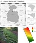
The study area comprises a 0.4 hectare vineyard block located at Curitibanos municipality, Santa Catarina state, southern Brazil (27°12′18″S, 50°37′10″W, SIRGAS2000), with an average elevation of 921 m.In this plot, ‘Sauvignon Blanc’ vines are grown for fine-wine production, being grafted onto 1103 Paulsen rootstocks and trained to a vertical trellis as single-cordon using spur-pruning method. The pedological spatial distribution correlates strongly with relief, with predominance of LATOSSOLOS and NITOSSOLOS on gentler slopes, while NEOSSOLOS and CAMBISOLOS occurring primarily on highly rugged terrain (Heberle & Almeida, 2016). |Regional climate is classified as Cfb (Köppen), i.e., temperate with no dry season and a warm summer (Alvares et al., 2013). Hence, annual average temperature ranges from 15.8 to 17.9 °C (minimum between 10.8 and 12.9 °C and maximum between 22.3 and 25.8 °C) and total annual precipitation ranges from 1,460 to 1,820 mm (Embrapa, 2012).
Soil sampling and analyses
Sixty-eight vines were georeferenced using GNSS (UTM zone 22S, SIRGAS2000) and adjacent to each vine, soil samples were taken at 0–20 and 20–40 cm depths (n = 136). Samples were air-dried, gently crumbled and sieved to 2 mm prior to physical and chemical analyses. Soil Ca2⁺, Mg2⁺, Na⁺, K⁺, Al3⁺, H⁺+Al3⁺, pH(H₂O), pH(KCl), organic carbon, and particle-size distribution (sand, silt, clay) were determined according to Embrapa (2017) and the sum of bases (SB), a proxy for soil fertility, was calculated according to Tedesco et al. (1995). The “Manual de Descrição e Coleta de Solo” (Santos et al., 2015) was used for morphological description of the profiles and the soil classification followed the “Sistema Brasileiro de Classificação de Solos” (Santos et al., 2018). To support classification, Fe₂O₃, Al₂O₃, and SiO₂ were determined by X-ray fluorescence (Silva et al., 2020). Lateral transitions between profiles were determined considering topographic position and variation in chemical and physical properties.
Production and plant structure
In 2023, individual grape yields were recorded for each georreferenced vine (kg vine⁻1), along with the number of clusters (n_cachos), total shoots (ramos), and fruitful shoots (ramos_prod). Derived metrics included: (i) kg per cluster (prod/n_cachos); (ii) clusters per fruitful shoot (n_cachos/ramos_prod); and (iii) shoot fertility (ramos_prod/ramos, %).
Spatial and statistical analysis
From point measurements, continuous surfaces were generated by through Natural Neighbour (Sibson) interpolation on a regular grid using SAGA GIS 7.8.2 (Conrad et al., 2015), ensuring consistency with the soil layers. Associations between yield and structural variables were evaluated by simple linear regression (fit and Pearson correlation coefficient, r). Management zones were obtained by k-means clustering (k ∈ {2, 3, 4}) and the number of clusters was selected using the silhouette index, based on a matrix of standardized variables. Computations were performed in Python (NumPy, SciPy, scikit-learn, Matplotlib).
Methodological notes
All maps are presented in UTM zone 22S (SIRGAS2000), with standardized units and scales. To ensure reproducibility, processing routines and georeferenced files were organized and archived, and figures exported at ≥ 300 dpi. Where appropriate, numerical results are reported as ranges or quantiles to avoid over-interpretation of average values under high spatial variability.
RESULTS AND DISCUSSION
Field investigation identified three soil classes in the vineyard block—NITOSSOLO BRUNO Distroférrico típico (NBdf), LATOSSOLO VERMELHO Distroférrico típico (LVdf), and LATOSSOLO BRUNO Distroférrico típico (LBdf)—as shown in Figure 2.
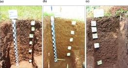
Distinct soil profiles found in the study area: (a) NITOSSOLO BRUNO Distroférrico típico; (b) LATOSSOLO VERMELHO Distroférrico típico; (c) LATOSSOLO BRUNO Distroférrico típico.
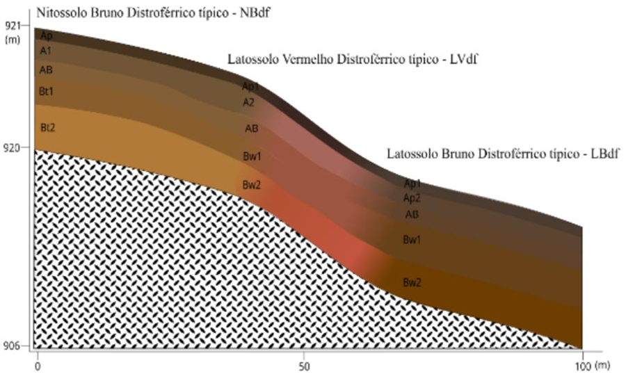
The presence of three soil profiles reveals pronounced pedological heterogeneity across the study area. In Profile 1 (NBdf), the sequence begins with an Ap horizon of dark brown soil, with a clayey texture and strong, fine subangular blocky structure. This horizon grades into an A1 horizon, retaining the same pedological features but with a darker hue and a planar transition. The AB horizon is also dark brown and very clayey, with moderate, fine subangular blocks and a diffuse, planar transition. At greater depth, Bt1 and Bt2 horizons occur with features similar to the AB horizon but showing moderate to strong clay coatings (argillans) and diffuse, planar transitions.
In Profile 2 (LVdf), the Ap horizon is very dark brown, with a medium, moderate subangular blocky structure. The transition to the A horizon is gradual, maintaining a clayey texture and a medium, moderate subangular blocky structure. The BA horizon is dark reddish brown and very clayey, with fine, moderate subangular blocks. Deeper horizons (Bw1, Bw2) show diffuse, planar transitions and remain dark reddish brown, very clayey, with medium to weak subangular blocky structure.
In Profile 3 (LBdf), the Ap1 horizon is dark reddish brown with a medium, moderate subangular blocky structure. The transition to Ap2 is marked by a disturbed/mixed layer, retaining a clayey texture and a medium, weak subangular blocky structure. The AB horizon is similar to Ap2, with little clay illuviation. At depth, Bw1 and Bw2 show diffuse, planar transitions, with dark brown, very clayey materials and medium to weak subangular blocky structure, with scarce clay coatings.
These variations among profiles reflect the influence of parent material, topographic position, and weathering processes, highlighting the pedological complexity of the area and the importance of considering such differences in agricultural management (Alba et al., 2021). Integrating pedology and precision viticulture provides essential knowledge for vineyard planning, establishment, and management.
Lateral soil change can be abrupt, as exemplified by the transition from NITOSSOLO BRUNO Distroférrico típico (NBdf) to LATOSSOLO VERMELHO Distroférrico típico (LVdf) and then to LATOSSOLO BRUNO Distroférrico típico (LBdf) within a 100 m distance with a 15 m difference in altitude This shift is closely tied to changes in physical and chemical properties such as texture and the capacity to retain nutrients and water, which are key to vine development. Soil moisture was not measured in this study; inferences about temporary accumulation or reduced availability are based solely on topographic position and clay content. Concave, lower-lying portions of the terrain are expected to have greater moisture due to temporary water accumulation, however, confirmation would require direct measurements (e.g., soil-moisture sensors, tensiometers) and/or morphological evidence of hydromorphism, which could be contemplated in future works.
Although lateral transitions betweenclasses (NBdf, LVdf, LBdf) explain part of the observed heterogeneity, substantial variation also occurs within a given class particularly under rolling relief and continuous agricultural use. Fine-scale shifts in particle-size distribution, structure, and carbon content over short distances can alter water and nutrient retention/supply, producing edaphic mosaics that demand dense sampling and high-resolution analysis. Thus, the variability recorded in the vineyard arises from both inter-class differences and intra-class heterogeneity, underscoring the need for detailed pedological diagnosis.
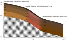
Topographic profile of the study area showing lateral soil change along the vineyard block.
Transitions between NBdf, LVdf, and LBdf soils can modify the availability of plant-essential nutrients such as phosphorus and potassium, owing to differences inits adsorption capacity (Pierangeli et al., 2001; Almeida et al., 2003). In addition, textural variation directly affects water retention and drainage, thereby influencing the water supply available to vines (Oliveira et al., 2010). Such contrasts may also lead to differences in root system development, given that a single vineyard block may encompass three distinct soil types, each with its distict physical characteristics. It is also relevant that the composition and diversity of soil bacterial communities may shift across soil-type transitions, which can indirectly affect vine health and development (Aira et al., 2022).
Taken together, these variations in soil composition and properties can affect viticulture in multiple ways, underscoring the importance of careful assessiment of soil characteristics when planning and managing vineyards, in order to ensure high-quality grape production. Within the scope of precision fruit production, detailed analysis of pedological attributes is key not only to management optimization but also to promote healthy crop growth. Understanding profile-to-profile variation and its relationship with nutrient and water availability offers valuable insight for strategic field decision-making.
Zoning for management
In precision viticulture, pedology should be understood as a critical data layer for interpreting the physical environment—important but, by itself, neither exclusive nor sufficient for management decisions. The generation of management zones depends on integrating multiple sources (soil, terrain, plant, climate, productivity). The present study addresses the matter by providing a high-resolution description of the edaphic dimension of the study area.
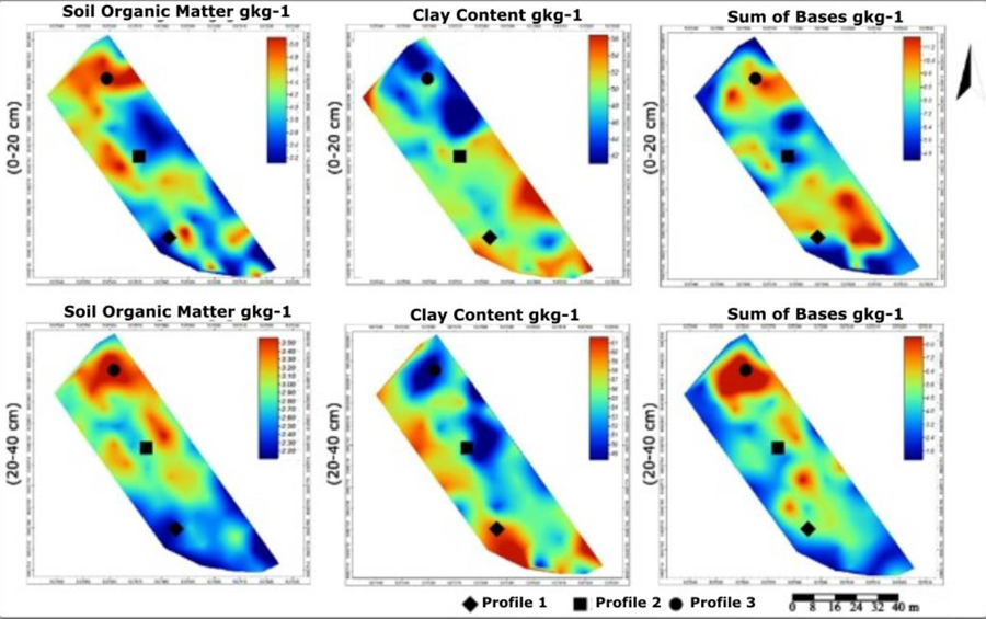
Regarding the spatial variation of attributes in the 0–20 and 20–40 cm layers (Figure 4), soil organic carbon and clay contents varied markedly between depths. Organic matter increased in the lower portion of the vineyard (Profile 1) in both layers, whereas clay content increased in the higher portion (Profile 3). In the central slope, water retention is lower due to steeper inclination, which promotes faster runoff than in the lower area. Consequently, organic carbon accumulation was greater in the lower sector, where higher moisture likely reduces mineralization, whereas clay content was lower. Both attributes are management-relevant and should be considered in decision-making.
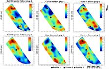
Interpolated maps (Natural Neighbour algorithm) for soil organic carbon (SOC), clay, and sum of bases (SB) in the 0–20 and 20–40 cm layers.
Regarding the sum of bases (SB), regions with higher values (>10 cmolc kg⁻1) were observed in the 0–20 cm layer of profiles 1 and 3, while in the 0-40cm layer, the highest values (>7 cmolc kg⁻1) where found solely the lower portion of the block (profile 3) i, indicating three-dimensional spatial variation across the main rooting zone. Studies indicate that nutrient availability in the 0–20 and 20–40 cm layers plays a critical role in plant development (Brunetto et al., 2015), particularly in deeper ones(Barreto et al., 2022), given that grapevine root system commonly extends beyond 40 cm depth.
Spatial heterogeneity in clay, organic carbon, and SB can guide variable-rate liming and fertilization and highlight priority areas for irrigation adjustments (where applicable). The literature shows that explicitly accounting for edaphic variability improves input-use efficiency and the agronomic coherence of management zones; however, practical implementation requires integrating soil maps with plant indicators and, ideally, with yield maps.
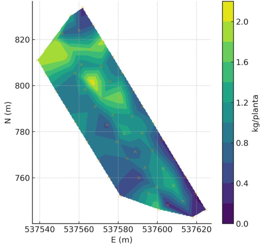
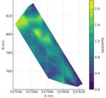
Figure 5 displays the within-block yield gradients, with higher- and lower-yielding areas aligned with slope orientation and the mapped pedological mosaic. This spatial organization confirms that edaphic heterogeneity translates into short-range yield variation, reinforcing the need for localized management.
Plant structure and yield
Associations between yield and structural traits indicate that number of clusters per vine is the main local determinant (high r), followed by kg per cluster and fruitful shoots; in contrast, total shoots and shoot fertility show a moderate effect. These resuslts suggests that spatial variation in crop load and in average cluster size explains a substantial share of the within-block variation in yield.
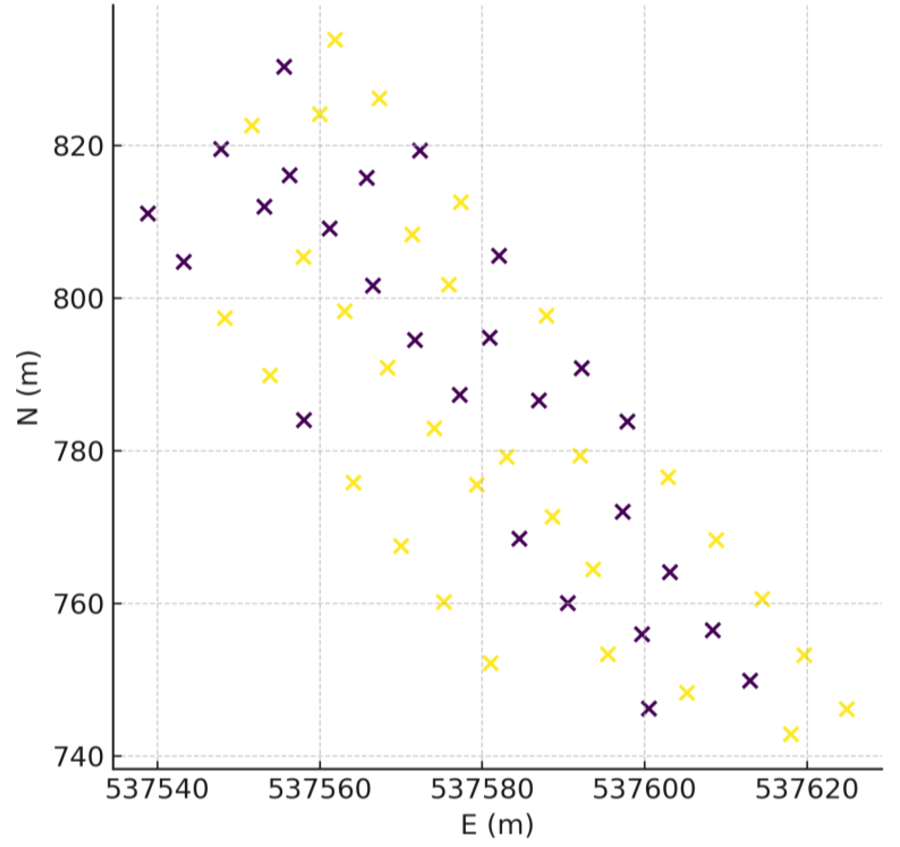
Management zones derived from yield and structure. Integrating yield (kg vine⁻1) with structural attributes (n_cachos, ramos_prod, ramos) produced management zones via k-means clustering (number of clusters selected by the silhouette index; k = 2–4), as shown in Figure 6. These zones synthesize differences in crop load and efficiency into operational units and their spatial expression, supporting targeted sampling, variable-rate liming and fertilization, and management adjustments aiming uniform production and quality while levraging spatial variability.

CONCLUSIONS
This study demonstrated marked small-scale pedological heterogeneity in a high-altitude vineyard, with three distinct soil classes and pronounced variation in physical and chemical attributes. Detailed pedological characterization—grounded in profile description and classification—proved essential to interpret the field spatial variability and guide high-resolution diagnosis and sampling strategies, reinforcing the role of soil in vineyard planning.
Integrating per-vine yield metrics with edaphic layers revealed spatial patterns coherent with topography and the soil mosaic, indicating that local yield variation is driven primarily by crop load (number of clusters), followed by differences in average cluster size and the proportion of fruitful shoots. Translating this information into operational zones obtained by clustering provides a practical path to improve liming/fertilization efficienty, guide drainage/irrigation and adjust management activities (e.g., thinning, leaf removal andharvest).
Conceptually, pedology provides the “first map”: by making soil bodies and their genesis explicit at plot scale, it establishes a secure foundation for integrating plant and production indicators and, when available, must-quality indicators, thereby reducing uncertainty and avoiding simplified generalization. Future work should deepen integration with physiological variables and yield maps, as well as directly quantify water availability (e.g., soil-moisture sensors; derived/validated available water capacity), to validate and refine the proposed management zones.
Beyond confirming short-range pedological heterogeneity, the results show that per-vine yield exhibits spatial patterns aligned with relief and the soil mosaic, being influenced mainly by crop load and, to a lesser extent, by average cluster size and the proportion of fruitful shoots. Deriving management zones from yield + structure offers a practical basis for partitioned correction/fertilization, targeted sampling, and practice adjustments. Subsequent studies should integrate these zones with edaphic layers and, when available, must indicators (°Brix/SST, pH, titratable acidity—ATT), consolidating edapho-productive zones for decision-making.
REFERENCES
-
Aira, M., Perez-Losada, M., Crandall, K. A., & Dominguez, J. (2022). Composition, structure and diversity of soil bacterial communities before, during and after transit through the gut of the earthworm Aporrectodea caliginosa. Microorganisms, 10(5), 1025. https://doi.org/10.3390/microorganisms10051025
» https://doi.org/10.3390/microorganisms10051025 - Alba, J. M. F., Flores, C. A., & Miele, A. (2021). Relationships between A and B/A2 horizons of three soils in the context of viticulture. Journal of Agricultural Studies, 9 (1), 440-454.
-
Almeida, J. A., Torrent, J., & Barrón, V. (2003). Cor de solo, formas do fósforo e adsorção de fosfatos em latossolos desenvolvidos de basalto do extremo-sul do Brasil. Revista Brasileira de Ciência do Solo, 27 (6), 985-1002. https://doi.org/10.1590/S0100-06832003000600003
» https://doi.org/10.1590/S0100-06832003000600003 -
Alvares, C. A., Stape, J. L., Sentelhas, P. C., Moraes, J. L. G., & Sparovek, G. (2013). Köppen's climate classification map for Brazil. Meteorologische Zeitschrift, 22 (6), 711 - 728. https://doi.org/10.1127/0941-2948/2013/0507
» https://doi.org/10.1127/0941-2948/2013/0507 -
Barreto, C. F., Antunes, L. E. C., Novraski, R., Benati, J. A., Ferreira, L. V., & Nava, G. (2022). Potassium fertilization and its impact on production and mineral composition of peach trees. Revista Brasileira de Fruticultura, 44 (4), e - 208. https://doi.org/10.1590/0100-29452022208
» https://doi.org/10.1590/0100-29452022208 -
Brunetto, G., Melo, G. W. B., Toselli, M., Quartieri, M., & Tagliavini, M. (2015). The role of mineral nutrition on yields and fruit quality in grapevine, pear and apple. Revista Brasileira de Fruticultura, 37, 1089-1104. https://doi.org/10.1590/0100-2945-214/15
» https://doi.org/10.1590/0100-2945-214/15 -
Conrad, O., Bechtel, B., Bock, M., Dietrich, H., Fischer, E., Gerlitz, L., Wehberg, J., Wichmann, V., & Böhner, J. (2015). System for Automated Geoscientific Analyses (SAGA). Geoscientific Model Development, 8 (7), 1991-2007. https://doi.org/10.5194/gmd-8-1991-2015
» https://doi.org/10.5194/gmd-8-1991-2015 - Embrapa. (2012). Atlas climático da Região Sul do Brasil: Estados do Paraná, Santa Catarina e Rio Grande do Sul. Embrapa Clima Temperado; Embrapa Florestas.
- Embrapa. (2017). Manual de métodos de análise de solo (3ª ed.). Embrapa Solos.
-
Ferreira, R. A., Carvalho, L. F. D., Fogaça, A. O., Amaral, L. P., Gebler, L., & Amado, T. J. C. (2023). Análise da variabilidade espacial e zonas de produtividade em vinhedos, no Vale Central Gaúcho. Nativa, 11 (3), 240-247. https://doi.org/10.31413/nativa.v11i3.15696
» https://doi.org/10.31413/nativa.v11i3.15696 -
Filippini-Alba, J. M., Flores, C. A., & Miele, A. (2017). Geotechnologies and soil mapping for delimitation of management zones as an approach to precision viticulture. Applied and Environmental Soil Science, 1-10. https://doi.org/10.1155/2017/4180965
» https://doi.org/10.1155/2017/4180965 - Heberle, D. A., & Almeida, J. A. (2016). Solos. In I. de O. Rocha (Org.), Atlas geográfico de Santa Catarina: Diversidade da natureza (2ª ed., Vol. 2, pp. 141-155). UDESC
-
Jasse, A., Barry, A., Aleixandre-Tudo, J. L., & Poblete-Echeverría, C. (2021). Intra-block spatial and temporal variability of plant water status and its effect on grape and wine parameters. Agricultural Water Management, 246, 106693. https://doi.org/10.1016/j.agwat.2020.106696
» https://doi.org/10.1016/j.agwat.2020.106696 - Miele, A., Flores, C. A., Filippini-Alba, J. M., Badalotti, C. B. (2014). Efeito do tipo de solo nos compostos fenólicos e na atividade antioxidante do vinho. Revista Brasileira de Viticultura e Enologia, 6, 40-47.
-
Pierangeli, M. A. P., Guilherme, L. R. G., Oliveira, L. R., Curi, N., & Silva, M. L. N. (2001). Efeito da força iônica da solução de equilíbrio sobre a adsorção/dessorção de chumbo em Latossolos brasileiros. Pesquisa Agropecuária Brasileira, 36, 1077-1084. https://doi.org/10.1590/S0100-204X2001000800009
» https://doi.org/10.1590/S0100-204X2001000800009 - Santos, H. G., Jacomine, P. K. T., Anjos, L. H. C., Oliveira, V. A., Lumbreras, J. F., Coelho, M. R., Almeida, J. A., Araujo Filho, J. C., Oliveira, J. B., & Cunha, T. J. F. (2018). Sistema Brasileiro de Classificação de Solos (5ª ed.). Embrapa Solos.
- Santos, R. D., Santos, H. G., Ker, J. C., Anjos, L. H. C., & Shimizu, S. H. (2015). Manual de descrição e coleta de solo no campo (6ª ed.). Sociedade Brasileira de Ciência do Solo.
-
Silva, D. J., Silva, A. O., Bassoi, L. H., Costa, B. S., Teixeira, R. P., & Souza, D. M. (2020). Adubação orgânica e fertirrigação potássica em videira 'Syrah' no semiárido. Irriga, 1 (1), 168. https://doi.org/10.15809/irriga.2020v1n1p168
» https://doi.org/10.15809/irriga.2020v1n1p168 -
Souza, S. A., & Rodrigues, L. (2022). Irrigation management zone strategies impact assessment on potential crop yield, water and energy savings. Agricultural Water Management, 271, 107788. https://doi.org/10.1016/j.agwat.2022.107788
» https://doi.org/10.1016/j.agwat.2022.107788 - Tedesco, M. J., Gianello, C., Bissani, C. A., Bohnen, H., & Volkweiss, S. J. (1995). Análise de solo, plantas e outros materiais (Boletim Técnico nº 5). UFRGS, Departamento de Solos.
-
Tian, M., Liu, Y., Lu, Hu L.,Wang, Y., Cheng, C., Chen,W., Li, S., He, F., Duan, C., Wang, J. (2022). Cluster spatial positions varied the phenolics profiles of 'Cabernet Sauvignon' grapes and wines under a fan training system with multiple trunks. Food Chemistry, 132930. https://doi.org/10.1016/j.foodchem.2022.132930
» https://doi.org/10.1016/j.foodchem.2022.132930
-
DATA AVAILABILITY STATEMENT:
The datasets generated and analyzed during the current study are available from the corresponding author on reasonable request.
-
FUNDING:
This research was funded by the Fundação de Amparo à Pesquisa de Santa Catarina (FAPESC), grant numbers 2021TR001707 and 2023TR000276. Research Productivity Grant (PQ), CNPq No. 304642/2022-3.
Edited by
-
Area Editor:
Lucas Rios do Amaral
The datasets generated and analyzed during the current study are available from the corresponding author on reasonable request.