The participatory social cartography unveiling fishing territorialities in Maxaranguape (Rio Grande do Norte, Brazil)
Abstract
Starting from the theme of artisanal fishing, in the context of the lack of legislation that guarantees the demarcation and conservation of fishing territory in Brazil, which is constantly threatened by territorial and socio-environmental conflicts, this work aimed to identify traditional fishing territorialities in the municipality of Maxaranguape, state of Rio Grande do Norte (RN), Brazil. Justifying it due to the lack of legal instruments that ensure this territory, a fact that also makes the fishermen invisible, blurring their identity, there is a need to produce testimonies about this territorial occupation built through territorialities that are related to the identity and traditional way of life of the fisherman. Regarding the research methodology, we used fieldwork, participant observation, interviews with semi-structured scripts, and participatory social cartography, to elaborate the maps of the Fishing Territory of Maxaranguape. It is concluded that participatory social cartography can be a powerful tool for the understanding and protection of traditional territory, especially in relation to traditional practices such as artisanal fishing. This approach can help strengthen the identity of the individuals and reveal the social and cultural consciousness associated with traditional territories and practices.
Keywords:
Participatory social cartography; Raftsmen; Participatory social maps; Artisanal fishing; Fishing territories
Resumo
Partindo do tema da pesca artesanal, no contexto da falta de uma legislação que garanta a demarcação e conservação do território pesqueiro no Brasil, que é constantemente colocado em ameaça devido à conflitos territoriais e socioambientais, este trabalho objetivou identificar as territorialidades tradicionais pesqueiras no município de Maxaranguape, Rio Grande do Norte (RN), Brasil. Justificando-o pela falta de instrumentos legais que assegurem esse território, fato que também torna os pescadores invisibilizados, borrando sua identidade, há a necessidade de produzirmos testemunhos sobre essa ocupação territorial construída por meio das territorialidades que estão relacionadas com a identidade e com o modo de vida tradicional pesqueiro. No que tange a metodologia de pesquisa, utilizamos o trabalho de campo, a observação participante, as entrevistas com roteiros semiestruturados e a cartografia social participativa, para, assim, elaborarmos o mapa do Território Pesqueiro de Maxaranguape. Conclui-se que a cartografia social participativa pode ser uma ferramenta poderosa para a compreensão, delimitação e proteção do território tradicional, especialmente em relação às práticas tradicionais como a pesca artesanal. Essa abordagem pode ajudar a fortalecer a identidade dos sujeitos e a revelar a consciência social e cultural associada aos territórios e as práticas tradicionais.
Palavras-chave:
Cartografia social participativa; Jangadeiros; Mapas sociais participativos; Pesca artesanal; Territórios pesqueiros
Resumen
Partiendo del tema de la pesca artesanal, en el contexto de la falta de una legislación que garantice la demarcación y conservación del territorio pesquero en Brasil, que está constantemente amenazado debido a conflictos territoriales y socioambientales, este trabajo tiene como objetivo identificar las territorialidades pesqueras tradicionales en el municipio de Maxaranguape, Rio Grande do Norte (RN), Brasil. Justificándolo por la falta de instrumentos legales que aseguren este territorio, un hecho que también invisibiliza a los pescadores, borrando su identidad, existe la necesidad de producir testimonios sobre esta ocupación territorial construida a través de las territorialidades que están relacionadas con la identidad y con el modo de vida tradicional pesquero. En cuanto a la metodología de investigación, utilizamos el trabajo de campo, la observación participante, las entrevistas con guiones semiestructurados y la cartografía social participativa, para elaborar el mapa del Territorio Pesquero de Maxaranguape. Se concluye que la cartografía social participativa puede ser una herramienta poderosa para la comprensión, delimitación y protección del territorio tradicional, especialmente en relación con las prácticas tradicionales como la pesca artesanal. Este enfoque puede ayudar a fortalecer la identidad de los sujetos y revelar la conciencia social y cultural asociada a los territorios y las prácticas tradicionales.
Palabras clave:
Cartografía social participativa; Jangaderos; Mapas sociales participativos; Pesca artesanal; Territorios pesqueros
Introduction
Coastlines all over the world have been home to societies that over time have developed an intimate relationship with the sea, in which it has been present in their cultures and worldviews, establishing meanings for their practices, uses and representations. Artisanal fishing is a traditional activity that results from these interactions and has been present since the origins of human societies, establishing close links between human groups and their environments, shaping different management techniques that are specific and adapted to each place (Diegues, 2004).
This process has also created different social groups with traditional cultures that have traditional/alternative ways of life related to fishing and the social appropriation of the marine and coastal environment, which are reproduced as identities (Diegues, 2008; Suzuki, 2013).
In Brazil, fishing is currently practiced by many of these groups, including the so-called (generically) jangadeiros, who are artisanal fishermen and occasionally small farmers, found between the states of Bahia and Ceará and who use artisanal fishing techniques (nets, line and fishhook, harpoon, etc.) and the raft as their vessel, an element that characterizes them par excellence (Cascudo, 2002).
The aim of this work was to identify fishing territorialities in Maxaranguape, Rio Grande do Norte (RN), Brazil, through participatory social cartography, carried out through a workshop, as well as informal conversations and interviews with artisanal fishermen and local residents. Participatory social cartography is a collaborative research methodology widely used in research with traditional peoples and communities (Almeida, 2018), enabling the representation of local knowledge and promoting the active participation of communities in the process of mapping and territorial analysis (Acserald; Coli, 2008). The workshop was held with the artisanal fishermen of Maxaranguape and organized by the Cabo de São Roque Environmental Protection and Conservation Association (APC)1 .
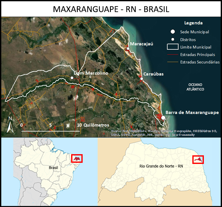
Maxaranguape (Map 1) has an average HDI of 0.608, an estimated population of 10,255 and an area of 132 km2 (Instituto Brasileiro de Geografia e Estatística, 2023). Both in the municipal seat (Barra de Maxaranguape) and in the two coastal districts (Caraúbas and Maracajaú), fishing is among the main productive activities, along with agriculture and services (mainly tourism).
– Location of Maxaranguape (Rio Grande do Norte, Brazil). Map created by the authors using images from Google Earth.
In this work, the focus was on demonstrating how participatory social cartography can reveal territorialities related to traditional practices, in particular artisanal fishing. According to Pelegrina (2020), this strategy can be used as a way of protecting and conserving traditional territory, promoting its social (re)appropriation.
Participatory social maps have emerged as an instrument to demonstrate which territorialities are constructed by traditional, popular and symbolic knowledge and traditional production practices (Acserald; Coli, 2008). In the case of this study, by artisanal fishing activity, demonstrating that these territorialities, together with the way of life, construct the traditional fishing territory.
In this context, territory is seen as the direct product of the territorialities defined by social groups through their institutions and practices (Little, 2015), the result of the articulation of social processes that result in the creation of materialities and symbolic relationships, being a cultural, historical and social construction, linked to the domination and appropriation of spaces and social groups (Haesbaert, 2021; Saquet, 2015).
Territoriality, on the other hand, is the system of relationships that shapes the territory, being the identity, immaterial and symbolic aggregation to the more traditional idea of territory, and which mentions the specificity of the place and its particularities, a way of acting that is innate to human groups, whose expression depends on the historical and environmental conditions in which the group is inserted (Haesbaert, 2021; Little, 2015; Saquet, 2019).
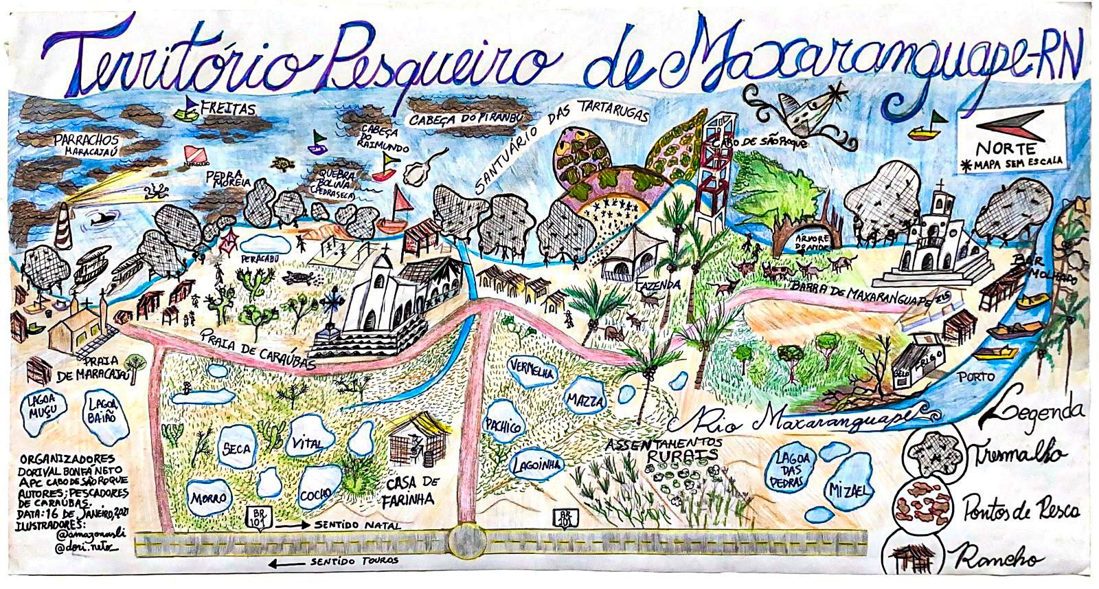
These foundations served as a basis for identifying fishing territorialities and thus constructing - together with local fishermen - maps of the traditional fishing territory of Maxaranguape (Maps 2 and 3).
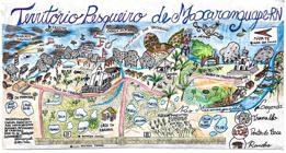
– Maxaranguape fishing territory. Organizers: Dorival Bonfá Neto and APC. Source: Fieldwork (2021).
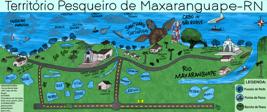
– Maxaranguape fishing territory (digital version). Organizers: Dorival Bonfá Neto and APC. Source: Fieldwork (2021).
Participatory Social Cartography
Geographer Jacques Lévy (2008) criticizes traditional cartography, especially in relation to the way in which maps were constructed under a Cartesian and Euclidean logic, through geodesic precision that eliminated the dimensions of myths and imaginaries and valued technical uses such as military, navigation, institutional planning, etc.
However, these narratives began to be questioned, so that in the 1990s, new possibilities for mapping became visible, which went beyond the traditional hegemonic actors, such as the state and large companies (Fernandes, 2016). In this context, non-hegemonic actors, such as social movements, traditional communities and marginalized groups, are gaining relevance in the construction of cartographic representations (Crampton; Krygier, 2005). These new approaches include Critical Cartography, which originated in the USA with John Brian Harley, who developed a critical theory of maps (Harley, 1992 [1989]), and Participatory Social Cartography, which originated in Brazil with Alfredo Wagner de Almeida2 (Almeida, 1995, 2018).
The main advances of this “critical turn in cartography” (Ribeiro; Silva, 2022, p. 5), characterized by greater engagement and consideration of the social implications of cartographic knowledge, lie in questioning the notions of power, ideology and vigilance presented in the mapping process, aiming to unveil these ulterior intentions and propose new emancipatory use of maps (Ribeiro; Silva, 2022).
Participatory social cartography, practiced in opposition to the hegemonic cartography model, is a methodology that aims to record reports and representations of space, identifying use and occupation in the territory for the process of self-mapping (Pelegrina, 2020). In the field, participatory mapping procedures are used, such as the creation of sketch maps and different methods for creating social/popular cartographies.
Participatory social cartography,
[…] is an instrument for defending the rights of traditional peoples and communities that secures and protects their territories, their social, cultural and natural heritage, through the search for the group's self-awareness in the representation of its territory and its territorialities (Bonfá Neto; Suzuki, 2023, p. 7, authors’ translation).
Traditional peoples and communities cannot be understood separately from their territories, to which their socio-cultural identity is intimately linked and which are characterized by being linked in the material and symbolic field, to belonging, land, history, traditional practices, identity, rituals etc. (Diegues, 2008; Suzuki, 2013). Traditional territory is constructed from territorialities that are linked to all forms of life reproduction, in their social, political, economic, environmental and cultural dimensions (Haesbaert, 2021; Saquet, 2015).
By integrating cartography and participatory mapping into territorial planning, mobilizing and connecting actors to territories and associating them with the production of knowledge about these places, it is possible to contribute to sustainable territorial development, as proposed by Saquet (2019) and Little (2015). Saquet proposes development based on the social and natural singularities of the territory, while Little emphasizes the social and economic protagonism of ethnic groups and the pillars of food sovereignty, cultural autonomy and territorial security. Both approaches emphasize the importance of considering local particularities and promoting the active participation of communities in the development process.
Thereby, participatory mapping can encourage the construction of territorial and cultural autonomy, environmental sovereignty and the recognition of these peoples' rights over their traditional knowledge and territories. The elements present in the maps produced are representative of the socio-spatial relations and territorialities built through artisanal fishing as a productive and symbolic practice.
The collaborative construction of the maps
The maps were made during a workshop held on January 16, 2021, on Caraúbas beach (Maxaranguape district), at a fishing ranch on the beachfront, where fishermen and other residents usually gather to talk, pass the time, store fishing materials and divide up and/or sell their catch.
In order to hold the workshop, we held a morning meeting with the fishermen and, in the meantime, began to draw up the map. As a starting point, we outlined the coastline and, through conversations with the individuals, i.e. through geocollaboration (Pelegrina, 2020), we mapped the areas where the fishermen establish their territoriality.
During the workshop, other fishermen arrived, made comments and contributed to the map (Figure 1). Many debated whether the location of the places on the map were “further down, further up, further to such and such a side”, demonstrating spatial awareness. Once the main points had been entered in a draft, we transferred the mapped elements to another piece of cardboard and went on to identify some locations and improve the drawings, according to the fishermen's instructions, in order to draw up a first version of the map.
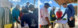
– Mapping workshop with fishermen. Caraúbas Beach (Maxaranguape-RN), Saturday, Jan. 16, 2021. Photo: Isadora N. Barreto (APC).
After drawing up a first version of the map, built synchronously in the workshop, we made a more illustrative and artistic map (Map 2), guided by a semiotic view of art and culture, which considers it to be a set of significant symbols that involve human beings in a “web of meanings”, as proposed by Clifford Geertz (2008).
In the final maps (Maps 2 and 3), we have located and inserted the points that are relevant to daily life and the traditional fishing way of life. We have tried to highlight the symbols of fishing culture that were indicated by the fishermen, such as the ranches, the fishing spots in the sea (the rocks and reefs), such as the “Parrachos de Maracajaú”), the places on the beach where trammel net fishing takes place, the lagoons, the “wet bar” (the most popular ranch among fishermen), the port, the ice factory and the nesting sanctuary for the hawksbill turtles (Eretmochelys imbricata). In the participatory social maps,
[...] instead of technical information, we tried to represent the territory lived and perceived by the community, the places that are relevant to local daily life, the experiences, the ways of working and their modes of collective existence, in an attempt to include everything that was relevant [...] The places and symbols represented on the maps do not deprive all reference to the “real” and express much more than the concrete manifestation of fishing spots, socializing and farming. ...] The places and symbols represented on the maps are not deprived of all reference to the “real” and express much more than the concrete manifestation of fishing, socializing, trading and farming sites, etc. (Bonfá Neto, 2023, p. 55, authors’ translation).
After making the first map (Map 2), a digital version was produced (Map 3). The final maps were built with the effective participation of the community involved, using participatory methods, dialog and collective mapping. As a result,
The maps revealed another fundamental element, which is the appropriation of the beach by the fishermen, mainly through the so-called dragnet fishing (BONFÁ NETO, 2022) and also the fishermen's ranches and living spaces. In addition, the maritime fishing territory has its places of reference for fishing, such as the paths, seats and bollards, which are secret and have not been revealed, as they are models of representation and appropriation of nature that are often considered secrets by the fishermen (Bonfá Neto, 2023, p. 364, authors’ translation).
From the final maps, we can conclude that the fishing territory is broad and involves the fishing spots, the sea, but also locations on land, such as beaches and villages, in other words, both the places on the fishing circuit and the symbolic territories, on land and at sea. In this way, “[...] public policies for traditional fishing communities should not be restricted to the sea or land, but should focus on the entire fishing territory [...]” (Bonfá Neto, 2023, p. 383, authors' translation).
Therefore, we can say that fishing is not just limited to a productive activity, since people's connection with fishing not only generates territorialities, but also shapes their identities. Fishing and the sea play a fundamental role in the link between the territory (inhabited since ancient times) and the traditional way of life.
Conclusion
In the maps produced, we tried to map the territory lived and perceived by the community, including the places that are relevant to local daily life, experiences, productive and symbolic practices and modes of collective existence. The elements mapped on the final maps are the result of the social relations experienced and the territorialities constructed. As researchers, we helped ensure that the final map reflected the subjects' understanding of their own territory and its relationship with their way of life.
The maps were able to demonstrate visions of the places where the territoriality of artisanal fishing was most evident and its scope, whose information was consistent with the perception we had during the field surveys. The actions and interventions carried out made it possible to capture the situation of fishermen as subjects who are aware of the importance of traditional and popular knowledge and know-how, as well as their appropriation of space and territoriality.
In this way, it became clear that the concept of territoriality is above all linked to kinship relations, work practices and a whole way of life, and that the articulation between knowledge, know-how and territory was made possible through participatory social cartography and its accessible language.
According to the results of the research, participatory social cartography can be used to protect traditional territory by promoting the recording of its social appropriation, bearing witness to and recognizing the relationship of traditional peoples and communities with the territory. It is important to emphasize that land is not considered private property by these groups, and threats to the territory also represent an interdiction to the existence and coexistence of these groups. In addition, it is essential to know the territories covered and to carry out diagnoses that take into account the territories traditionally occupied in rural areas. Protecting traditional knowledge is also crucial to preserving the territory, since it is the result of experiences, ways of life and productive activities in different contexts.
-
1
NGO founded in 2015, based in Maxaranguape and operating in the state of Rio Grande do Norte.
-
2
Among the works developed by Almeida, we highlight the Nova Cartografia Social da Amazônia (New Social Cartography of the Amazon) project, which emerged in the early 2000s to carry out collective mapping with traditional communities in the Brazilian Amazon (Almeida, 2018; Manaus, 2024).
-
How to cite this article:
BONFÁ NETO, D.; SANTOS, J. K. S. The participatory social cartography unveiling fishing territorialities in Maxaranguape (Rio Grande do Norte, Brazil). Geousp, v. 28, n. 2, e221533. 2024. https://doi.org/10.11606/issn.2179-0892.geousp.2024.221533en
References
-
ACSERALD, H.; COLI, L. R. Disputas territoriais e disputas cartográficas. In: ACSERALD, H. (ed.). Cartografias sociais e território Rio de Janeiro: IPPUR/UFRJ, 2008. p. 13-43. Disponível em: http://www2.fct.unesp.br/docentes/geo/raul/cartografia_tematica/leitura%204/Cartografias%20Sociais%20e%20Territ%F3rio.pdf Acesso em: 1 jun. 2021.
» http://www2.fct.unesp.br/docentes/geo/raul/cartografia_tematica/leitura%204/Cartografias%20Sociais%20e%20Territ%F3rio.pdf - ALMEIDA, A. W. B. Carajás: a guerra dos mapas. 2. ed. Belém: Supercores, 1995.
-
ALMEIDA, A. W. B. Mapas e museus: uma nova cartografia social. Ciência e Cultura, São Paulo, v. 70, n. 4, p. 58-61, 2018. DOI: http://doi.org/10.21800/2317-66602018000400016.
» https://doi.org/DOI: http://doi.org/10.21800/2317-66602018000400016 -
BONFÁ NETO, D. The net-pulling; cooperation, collectivity and mutual help in images. GIS: Revista de Antropologia, São Paulo, v. 7, n. 1, p. 1-37, 2022. Disponível em: https://www.revistas.usp.br/gis/article/view/190822 Acesso em: 27 maio 2024.
» https://www.revistas.usp.br/gis/article/view/190822 -
BONFÁ NETO, D. Territorio, modo de vida y pesca artesanal marítima: análisis comparativo entre Bahía Solano, en el Pacífico Colombiano, y Maxaranguape, en el Atlántico Brasileño. 2023. Trabajo de Grado (Doctorado en Geografia) –Universidad Nacional de Colombia, Bogotá, 2023. Disponível em: https://repositorio.unal.edu.co/handle/unal/85016 Acesso em: 27 maio 2024.
» https://repositorio.unal.edu.co/handle/unal/85016 -
BONFÁ NETO, D.; SUZUKI, J. C. Cartografía social participativa como metodología de investigación territorial: un estudio de caso en el Pacífico Afrocolombiano. Perspectiva Geográfica, Bogotá, v. 28, n. 1, p. 1-22, 2023. DOI: http://doi.org/10.19053/01233769.14529.
» https://doi.org/DOI: http://doi.org/10.19053/01233769.14529 -
CRAMPTON, J.; KRYGIER, J. An introduction to critical cartography. ACME: An International Journal for Critical Geographies, Vancouver, v. 4, n. 1, p. 11-33, 2005. Disponível em: https://acme-journal.org/index.php/acme/article/view/723/585 Acesso em: 25 maio 2024.
» https://acme-journal.org/index.php/acme/article/view/723/585 - CASCUDO, L. C. Jangada: uma pesquisa etnográfica. 2. ed. São Paulo: Global Editora, 2002 [1957].
- DIEGUES, A. C. S. A pesca construindo sociedades: leituras em antropologia marítima e pesqueira. São Paulo: Nupaup/USP, 2004.
- DIEGUES, A. C. S. O mito moderno da natureza intocada 6 ed. São Paulo: Hucitec/Nupaup, 2008.
-
FERNANDES, W. O. Mapas: entre narrativas pela dominação e dissertativas pela contestação. 2016. Dissertação (Mestrado em Geografia Física) – Programa de Pós-graduação em Geografia Física, Universidade de São Paulo, São Paulo, 2016. DOI: http://doi.org/10.11606/D.8.2017.tde-24022017-150348.
» https://doi.org/DOI: http://doi.org/10.11606/D.8.2017.tde-24022017-150348 - GEERTZ, C. A interpretação das culturas Rio de Janeiro: LTC, 2008 [1973].
- HAESBAERT, R. O mito da desterritorialização 13. ed. Rio de Janeiro: Bertrand Brasil. 2021.
-
HARLEY, J. B. Deconstructing the map Ann Arbor: MPublishing, University of Michigan Library, 1992 [1989]. n. 3, p. 10-13. Disponível em: https://quod.lib.umich.edu/p/passages/4761530.0003.008/--deconstructing-the-map?rgn=main;view=fulltext Acesso em: 24 maio 2024.
» https://quod.lib.umich.edu/p/passages/4761530.0003.008/--deconstructing-the-map?rgn=main;view=fulltext -
INSTITUTO BRASILEIRO DE GEOGRAFIA E ESTATÍSTICA – IBGE. Panorama Maxaranguape 2023. Disponível em: https://www.ibge.gov.br/cidades-e-estados/rn/maxaranguape.html Acesso em: 23 jan. 2024.
» https://www.ibge.gov.br/cidades-e-estados/rn/maxaranguape.html - LÉVY, J. Uma virada cartográfica? In: ACSERALD, H. (ed.). Cartografias sociais e território Rio de Janeiro: IPPUR/UFRJ, 2008. p. 153-168.
-
LITTLE, P. E. Desenvolvimento territorial sustentável: desafios e potencialidades para o século XXI. Guaju, Matinhos, v. 1, n. 2, p. 127-143, 2015. DOI: http://doi.org/10.5380/guaju.v1i2.45039.
» https://doi.org/DOI: http://doi.org/10.5380/guaju.v1i2.45039 -
MANAUS. Projeto Nova Cartografia Social da Amazônia Manaus, 2024. Disponível em: http://novacartografiasocial.com.br/ Acesso em: 28 maio 2024.
» http://novacartografiasocial.com.br/ -
PELEGRINA, M. A. Cartografia social e uso de mapeamentos participativos na demarcação de terras indígenas: o caso da TI Porto Limoeiro-AM. Geousp Espaço e Tempo, São Paulo, v. 24, n. 1, p. 136-152, 2020. DOI: http://doi.org/10.11606/issn.2179-0892.geousp.2020.138814.
» https://doi.org/DOI: http://doi.org/10.11606/issn.2179-0892.geousp.2020.138814 -
RIBEIRO, L. H. L.; SILVA, C. A. Cartografia da Ação Social e luta pelo uso do território no Brasil: contribuições à reflexão do método. GEOUSP Espaço e Tempo, São Paulo, v. 26, n. 2, p. 187-203, 2022. DOI: http://doi.org/10.11606/issn.2179-0892.geousp.2022.187100.
» https://doi.org/DOI: http://doi.org/10.11606/issn.2179-0892.geousp.2022.187100 - SAQUET, M. A. Por uma geografia das territorialidades e das temporalidades: uma concepção multidimensional voltada para cooperação e para o desenvolvimento territorial. 2. ed. Rio de Janeiro: Consequência, 2015.
-
SAQUET, M. A. O território: a abordagem territorial e suas implicações nas dinâmicas de desenvolvimento. Informe Gepec, Toledo, v. 23, n. esp., p. 25-39, 2019. DOI: http://doi.org/10.48075/igepec.v23i0.22719.
» https://doi.org/DOI: http://doi.org/10.48075/igepec.v23i0.22719 -
SUZUKI, J. C. Território, modo de vida e patrimônio cultural em sociedades tradicionais brasileiras. Espaço & Geografia, Brasília, v. 16, n. 2, p. 627-640, 2013. Disponível em: http://www.lsie.unb.br/espacoegeografia/index.php/espacoegeografia/article/view/272 Acesso em: 30 jun. 2021.
» http://www.lsie.unb.br/espacoegeografia/index.php/espacoegeografia/article/view/272
Edited by
-
Article editor
Paula Cristiane Strina Juliasz