Habitat risk assessment of fragmented mangal ecosystem using InVEST models: a case study in San Fernando City, La Union, Philippines
ABSTRACT
La Union is renowned as one of the major tourist destinations in the Philippines, primarily the City of San Fernando, which houses a vast stretch of pristine coastal and wetland ecosystem that includes tropical beach and lush mangrove forests. However, despite the beneficial services mangal ecosystem provides for the coastal communities of San Fernando City, La Union, they remain vulnerable to risk caused by anthropogenic stressors in exchange for growing economic development. To ascertain this observation in the region, it is urgent that an evidence-based decision framework for the habitat risk of the remaining patches of the mangal ecosystem in smaller districts (barangays) of the whole municipality be established. Hence, this study was conceived by employing a mangal assessment based on exposure and consequence scores from anthropogenic stressors using the InVEST Habitat Risk Assessment model. Key findings showed the following: (1) the business-as-usual scenario configures a high cumulative risk due to road structures and other concrete pavements, (2) in a controlled and protected scenario, the mangal ecosystem will likely shift from medium to low risk, and (3) a reduction in cumulative risk for the mangal ecosystem is expected under public-private partnership intervention scenario. Nevertheless, the remaining sites in which the mangal ecosystem thrives must be targeted for intense active intervention and management from private and public stakeholders. This study serves as the basis for data-driven policies, highlighting the importance of adequately implementing management strategies to protect a critical wetland habitat.
Keywords:
Management strategies; Mangroves; Remote Sensing; Stressors; Vulnerability
INTRODUCTION
Amidst their importance, the mangroves experience high pressure, leading to a loss of the total mangrove population over the last 50 years (Giri, 2016; Gouvêa et al., 2022). The reduction of mangrove coverage can be seen in various countries, leading to the substantial loss of habitats, species, and ecosystem services (Feller et al., 2017). In Southeast Asia, Myanmar significantly experienced mangrove loss of about 27.6% from 2000 to 2014 (Estoque et al., 2018), whereas about 2,150 ha of the total mangrove area was lost per year in the Mekong Delta, which houses around 84% of the mangroves in Vietnam (Phan and Stove, 2022; Tinh et al., 2022). In the Philippines, at least 50% of the global mangrove species can be found (Garcia et al., 2013; Prance and Tomlinson, 1987), with 39 species of true mangroves distributed throughout the archipelago (Primavera, 2004). The country houses about 311,400 ha of mangrove forest (Department of Environment and Natural Resources-Biodiversity Management Bureau, 2022). However, recent estimates show that about 20% of the total mangrove forest coverage in the Philippines has declined by 20% over the past three decades (Daquinan et al., 2023). Roughly less than half of the mangrove forest cover in the country was lost less than 100 years ago, resulting in notable habitat loss and increased habitat risk. Local restoration, mangrove reforestation, and mangrove plantations have been widely advocated but are insufficient to recover the coverage of mangals (mangrove forest and its associated plants) that were lost, which may be attributed to social demography and the level of awareness by the locals (Camacho et al., 2020; Quevedo et al., 2019; Walters, 2004).
Among the several regions along the coastlines of the Philippines, the province of La Union houses abundant natural resources and diverse ecosystems, including forests, uplands, mangals, and marine environments. As of 2020, within its 149,309 ha of land, La Union contained approximately 152 ha of mangal forest (Aduana-Alcantara et al., 2023). From 2011 to 2014, the Bureau of Fisheries and Aquatic Resources of the Philippines indicated that mangrove ecosystem conservation management and propagation efforts have been made by planting mangrove propagules of varying species. Due to its geographical location, the province is renowned as a major tourist destination in the Philippines, primarily the City of San Fernando. More than natural causes, anthropogenic activities serve as the primary threat to the stability of mangals within San Fernando City, La Union. Human settlements and the commercialization of areas occupying the coastal areas contribute to the increased risk of natural ecosystems and the reduction of mangal areas, reducing the productivity of coastal habitats and causing shoreline erosion and the loss of residential and agricultural states (Anca et al., 2017; Göltenboth et al., 2006; Salmo III et al., 2014). The San Fernando City Local Government Unit found that the dense concentration of human buildings in the coastal areas influenced the widespread pollution in the coastal waters, leading to sedimentation run-off and anthropogenic eutrophication (La Union Provincial Land Use Committee, 2015). Resource exploitation and the heightened use of the mangal ecosystem services (e.g., aquacultures) disrupt the natural structure and ecological balance of flora and fauna (Awuku-Sowah et al., 2022). Currently, minimal data characterizes the state of mangals within San Fernando City, La Union. The municipality experiences the repercussions of reducing mangroves (Salmo III et al., 2014). The local mangrove ecosystem in San Fernando City, La Union, intertwines with residential areas and the local community (Rivera et al., 2024).
InVEST is used to determine and calculate the risk to the local ecosystem components in terrestrial and marine habitats, wherein the risks are ranked according to their threat level (Arkema et al., 2014). InVEST models can generate maps and data to quantify and assess the overall change within the ecosystem concerning carbon sequestration, crop production, coastal vulnerability, renewable energy, water quality, recreation, habitat quality, and risk assessment (Stamoulis and Delevaux, 2015). Defining the changes in the structure and function of the ecosystem, considered as stressors, are correlated with the flow and value of ecosystem services for both land and seascape. Climate change and anthropogenic activities such as fishing, human-induced pollution, and coastal development configure stressors that impact the services and goods the local ecosystem provides to humans (Fletcher et al., 2005; Hobday et al., 2011). Multiple habitat stressors can be integrated into a single risk value using the HRA model by InVEST as a cost metric variable (The Natural Capital Project, 2017; Studwell et al., 2021). Several studies worldwide used the InVEST Habitat Risk Assessment (HRA) model to determine and quantify the risk scores of a coastal ecosystem under various approaches. In 2020, the InVEST HRA model introduced a method for spatially examining how ecosystem services supply affects habitat risk. In the Philippines, InVEST-based approaches to analyze and measure ecosystem services have been used, primarily focusing on carbon sequestration among watersheds in Laguna (Dida et al., 2021).
Due to the lack of specific regulations to manage and protect the mangals from neighboring anthropogenic activities, existing mangals have decreased in La Union. They show unsuitable conditions for survival and adaptation. As a result of insufficient current data on mangal health and the extent of coverage within the area alongside the range of exposure of human activities toward the mangals, a habitat risk decision framework is to serve as a baseline for initiatives on evidence-based policies that should be urgently implemented in La Union. Hence, using the HRA model in the InVEST software, the main objective of this study is to determine and calculate the risks in terrestrial and marine ecosystems.
METHODS
STUDY AREA
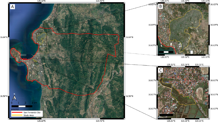
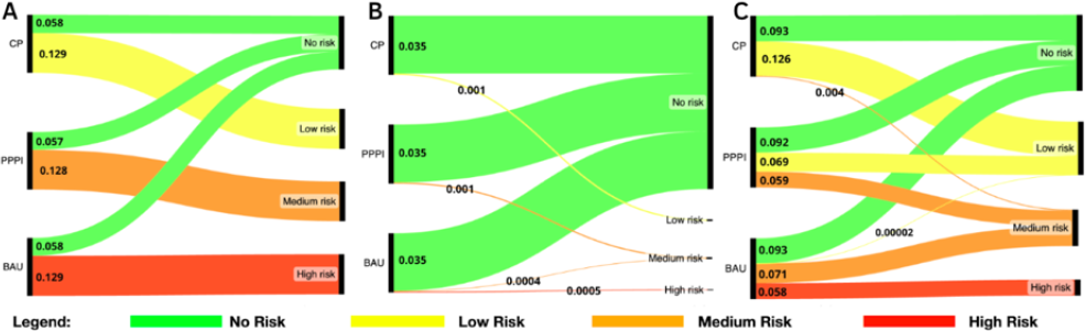
San Fernando City (Figure 1A) is bordered by the Cordillera Mountain Range in its eastern region and major bodies of water in its western flank. In contrast, prominent landforms, namely the coastal plain, rugged eastern interior, and inland valleys, occupy its total land area, with the coastal plain being the largest (Balaoro-Banzuela et al., 2023). The San Fernando Local Government Unit reported that the municipality is composed of 63.55 ha of creeks and mangals, which are classified by the municipality as protected areas under the Provincial Environmental Protection and Management Code of La Union (Provincial Government of La Union, 2002). The last remaining mangal sites in the municipality are found in two accessible coastal barangays with relatively dense residents in the middle of the wetland tributaries of the mangal sites. The first is named Carlatan (Figure 1B) and is situated at 16.6348° N, 120.3190° E. It is a coastal barangay with ca. 3500 inhabitants, and the main livelihood of its inhabitants involves building aquaculture and fishing. The second one is located at 16.6082° N, 120.3118° E and is called Catbangen (Figure 1C). This site is comparatively more densely populated (with around 11,000 residents of varying ages), and its housing infrastructure lies between the water tributaries, resulting in much of the fragmentation among mangrove plantations.

Mangal sampling sites in (A) the entire city, (B) Brgy. Carlatan, Dalumpinas Oeste, Biday, and (C) Catbangen-Porro in San Fernando City, La Union.
DATA INPUTS
Spatial data inputs, including mangrove habitats and anthropogenic stressors, were obtained by remote sensing data, field surveys, and publicly available datasets. High-resolution Sentinel-2 satellite imagery (10-m resolution) was used as a reference to map the extent of mangrove habitats and the anthropogenic stressors. Data processing and spatial analysis were performed in ArcGIS 10.8, in which habitat and stressor layers were mapped, classified, and analyzed for spatial and temporal overlaps. In total, 10 anthropogenic activities that stress the mangrove ecosystem were identified in the spatial zoning scheme: aquaculture, boats, bridges, land bridges, net fishing, spearfishing, mangrove walk, mega infrastructures, residential areas, and roads (see Supplementary Information Appendix A). After identifying the stressors, the first three authors of this study scored each stressor using technical reports and the related literature, using the expert opinion of a long-time environmental monitor and planner in the city (fourth author) and based on gathered socioecological information following the guidelines for HRA (the fifth and sixth author). The authors convened and discussed the initial scores until a unified score had been agreed upon by all stakeholders (Arkema et al., 2014; Garcia et al., 2013).
DATA SCORING
Assessment of the risk level imposed on an ecosystem by the InVEST HRA depends on evaluating exposure and consequence attributes. Exposure pertains to the extent to which a habitat experiences the stressors considering the effectiveness of the management policies in place, which is calculated by the software based on the level of exposure of mangals to the chosen 10 anthropogenic activities and their resulting consequences. Consequence integrates the sensitivity of the mangal ecosystem to the impacts of each stressor and its resilience and ability to recover from the impacts of stressors upon exposure. Following the criteria scoring in Arkema et al. (2014), habitat exposure depends on the (1) spatial overlap or the distribution of habitats and stressor, (2) temporal overlap, (3) intensity of the activity, and (4) management strategy effectiveness, which can reduce exposure. On the other hand, consequence scoring depicts the potential for habitat degradation, which is measured by its sensitivity and resilience to the stressors. Under sensitivity, (1) change in area or loss of areal extent, (2) change in structural density, and (3) frequency of natural disturbance are measured. Habitat resilience attributes cover the (1) natural mortality of biotic habitats, (2) recruitment of biotic habitats for re-establishment of population, (3) connectivity or the close spacing of habitat patches, and (4) recovery time. The risk scores for exposure and consequence range on a scale from one (low) to three (high). A score of 0 was placed when a criterion is inapplicable to the habitat. The data quality of each criterion was scored, ranging from one (best data) to three (limited data), to add greater consideration of a criterion with higher confidence in the calculation. The importance of each criterion was also assessed based on its level of importance, which dictates the impact of a stressor. The model utilized scoring of one (most important) to three (least important) (Table S1).
MODELLING HABITAT RISK
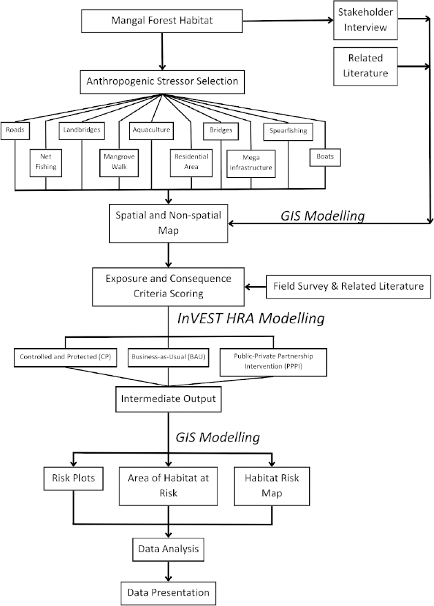
Following the modeling pipeline in Arkema et al. (2014), the data inputs underwent HRA modeling using the pipeline of the software InVEST (Figure 2), which, developed by the Natural Capital Project, comprises models that evaluate ecosystem services to aid environmental managers in decision-making (Sharp et al., 2015). Unlike other modeling software, the intuitive nature of InVEST only requires low data input demands. Hence, it can be used anywhere, even by non-technical experts (Cong et al., 2020). However, the software is limited by the availability and quality of input data as recent local assessments are necessary to yield the most accurate results for a certain study site. Moreover, the software is unable to account for past human activities on the current risk or how it contributes to the current consequence scores; only assessing stressors that directly impact the habitat. The InVEST HRA model, while effective, has inherent uncertainties that must be acknowledged: (i) the accuracy of spatial and temporal data on stressors depends on satellite imagery and local reports. The absence of high-resolution historical data may influence model precision; (ii) human activities fluctuate due to economic, social, and environmental changes; and (iii) parameter sensitivity, the risk scores of which are based on exposure and consequence factors that rely on expert judgment and literature review.

Schematic diagram of Mangal Habitat Risk Assessment using InVEST model in San Fernando City, La Union.
All data were analyzed under a one-meter resolution to produce more detailed risk maps. In total, six overlapping stressors were identified using ArcMap 10.8.2: (i) aquaculture, (ii) land bridges, (iii) spearfishing, (iv) net fishing, (v) roads, and (vi) residential areas. The researchers calibrated the model after collecting and processing observed data in the field and comparing it to the initial model output of InVEST. The analysis employed the Euclidean approach to estimate the specific habitat-activity combination risk. This approach is widely used for ecosystem risk assessment studies, providing a strong concordance between calculated risks, habitat fragmentation, and health measures (Arkema et al., 2014). No decay equation was utilized during the analysis to depict the stressors, imposing full effects on the buffer area to fully simulate the extent of the impact of each stressor on the local ecosystem. The selected area of interest was produced as a vector file of polygons representing the chosen habitats (Figure 1).
In total, three simulations showing distinct assumptions about the extent of human impact and conservation efforts - specifically (1) conserved and protected (CP), (2) business-as-usual (BAU), and (3) public-private partnership intervention (PPPI) - were done to predict future and current habitat risk of the mangal ecosystems (Figure 2). CP depicts the total absence of anthropogenic stressors acting on the mangal ecosystem, constituting the scenario that models a highly protected area because of successful management, rehabilitation, and intervention of the local ecosystem. While ideal, CP may be challenging due to governance limitations, economic pressures, and community dependence on coastal resources. However, it reflects the potential of a well-implemented conservation strategy if political and financial support is secured.
Under PPPI, collaborative efforts between government agencies, non-governmental organizations, and private stakeholders are taken to enforce conservation policies. This includes infrastructure modifications, eco-tourism integration, and sustainable aquaculture practices. This scenario is a pragmatic middle ground as public-private initiatives have been successful in similar conservation efforts. The involvement of stakeholders increases feasibility, making it a likely path for San Fernando City.
Meanwhile, BAU depicts and simulates the current status of the mangrove as evaluated by the local expert stakeholders, showing the full extent of the impacts of the stressors on the local mangal ecosystem. BAU is the most realistic representation of the current conditions in San Fernando City given its existing infrastructure development, unregulated fishing, and limited enforcement of mangrove conservation policies. It serves as the baseline for evaluating the efficacy of conservation measures.
Different sets of maps varying in the extent of human activities and changes in the ratings of exposure and consequence were used to model the three scenarios. The cumulative risk of an ecosystem is assessed as the summation of all risk scores for all stressors on each habitat (i) based on the combination of habitat and activity (Arkema et al., 2014).
The model outputs generated intermediate results in the form of raster and vector layers, which were subjected to the HRA dashboard and ArcGIS software to further visualize the risk plots, habitat risk maps, areas of habitat at risk, and a Sankey diagram. The summary statistics file yielded the habitat-stressor pairs with their respective exposure and consequence scores, alongside the percentage of each pair showing low, medium, and high risks.
MODEL VALIDATION
To enhance reliability, model validation was conducted by ground truthing on the field to compare model predictions with the observed actual habitat conditions and stressor impacts. The local environmental planners and ecologists reviewed model outputs to ensure alignment with known site conditions. Lastly, a sensitivity analysis with multiple iterations of the model was run with adjusted exposure and consequence scores to assess stability and robustness of risk classifications.
RESULTS
RISK MAPS
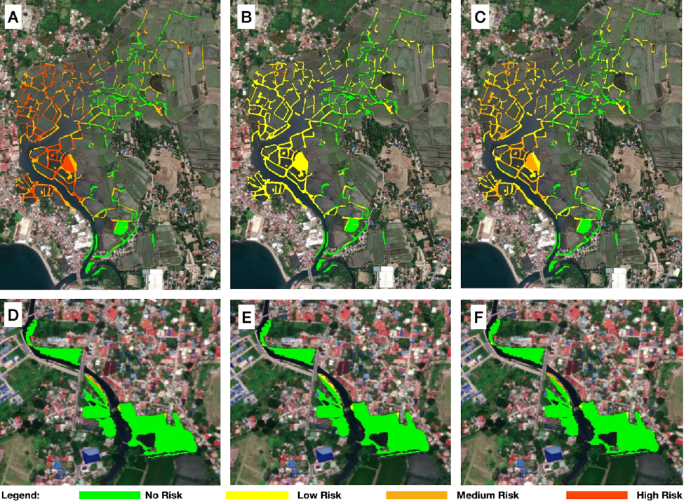
The InVEST HRA model under BAU showed high cumulative risk due to anthropogenic activities (Figure 3). Furthermore, the entire ecosystem is posed with exposure and consequence scores from all stressors equal to 0.18 and 0.12 for Carlatan and Catbangen, respectively. The highest stress contributors are road structures (E=1.24; C=1.23) for Carlatan and mangrove walk (E=0.03; C=0.02) for Catbangen. Under the three scenarios, results indicate that the western portion of Brgy. Carlatan is heavily affected by stressors, whereas the eastern portion shows little to no risk. This suggests the minimal effects of stressors within the local area. Throughout the different scenarios, no changes were observed among the areas classified under no risk, which are primarily situated in the eastern portion of Brgy. Carlatan. However, the western portion of Brgy. Carlatan displays varying risk levels under the three scenarios, in which a gradual decrease in the risk level was observed as the implementation of the management and intervention policies is simulated under PPPI and CP.
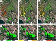
Risk map of mangal ecosystem in Brgy. Carlatan under (A) business-as-usual, (B) controlled and protected, (C) public-private partnership intervention, and Brgy. Catbangen under (D) business-as-usual, (E) controlled and protected, and (F) public-private partnership intervention.
Under CP, Brgy. Carlatan and Brgy. Catbangen showed a medium-to-low risk to the mangal ecosystem (Figure 3). Drastic reduction in the stressors yielded cumulative risks of 0.82 and 0 for Brgy. Carlatan and Brgy. Catbangen, respectively. of the stressors, roads (E=0.51; C=0.92) and land bridges (E=0.46; C=0.83) significantly contributed to the medium-risk areas, which were aligned to BAU results with only reduced intensity of disturbance. In PPPI, Brgy. Carlatan and Brgy. Catbangen showed cumulative risk in stressors equal to 0.11 and 0.004, respectively.
SHIFTS OF RISK IN BAU TO PPPI MODELS
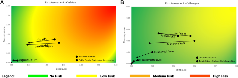
Brgy. Carlatan has a higher cumulative risk and exposure score than Catbangen. This is due to more stressors, which are composed of the two highest anthropogenic stressors under BAU. For Brgy. Carlatan, exposure and consequence include roads (E=1.24; C=1.23) and land bridges (E=1.37; C=1.05), whereas under PPPI, the model yielded the following values for roads (E=0.51; C=1.05) and land bridges (E=0.46; C=0.95). It is notable that the mangrove walk, evident in Brgy. Catbangen is only absent in the Brgy. Carlatan. Under BAU and PPPI, the model remains consistent in showing them as the two primary scenarios that heavily impact the risk factors of the mangal ecosystem within the local barangay. PPPI indicated a gradual reduction in exposure and consequences for roads and land bridges. Management approaches and intervention policies will reduce the exposure and consequence components of risk for the two stressors (Figure 4a), suggesting that the proposed policies will effectively reduce the overall risks of the mangal ecosystem in Brgy. Carlatan.
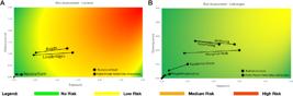
Risk plot of the mangal ecosystem showing the change between two scenarios in Brgy. (A) Carlatan and (B) Catbangen.
Catbangen showed an overall lower exposure and consequence score than Carlatan. Specifically, under PPPI for Brgy. Catbangen, the major stressors refer to net fishing (E=0.02; C=0.03), spearfishing (E=0.02; C=0.03), mangrove walk (E=0.01; C=0.02), and residential areas (E=0.01; C=0.01). Running the model under PPPI showed a decrease in the exposure of all stressors and consequence scores, except for net fishing and spearfishing. This can be attributed to the existing reliance of mangals on the initial level of exposure. Figure 4B shows that a reduction in the exposure components of risk is possible with positive interventions and policies from the management.
QUANTITATIVE CHANGES OF MANGAL SITE RISK UNDER DIFFERENT SCENARIOS
By the InVEST HRA model, the cumulative risks from the anthropogenic activities were assessed based on roughly 0.220 km2 or 22 ha of total mangal areas in Brgy. Carlatan and Brgy. Catbangen. Based on the model, Brgy. Carlatan comprises approximately 0.186 km2 of mangal areas, in which the three scenarios had varying risk results for the local ecosystem. Throughout the three scenarios, about 30.89% of the mangal habitat area in Brgy Carlatan showed no risk, whereas the absence of risks for BAU and CP had the same values (Figure 5A). Results in Figure 5A showed 69.21% of the mangal habitat area in Brgy. Carlatan is at high risk under BAU and at low risk under CP, showing a gradual decrease in the risk levels of the local ecosystem as interventions are implemented. PPPI showed a 68.52% shift in the mangal area, reducing the risk of the local barangay from high to medium. Figure 5B shows that 97% of the mangal areas are risk-free for the Barangay in all scenarios. Catbangen, which houses about 0.036 km2 of mangal areas. Only about 1.03% and 1.47% of the total area is under medium and high risk, respectively. An observable shift occurred under PPPI, in which areas with medium risk totaled 2.22%. However, areas of high risk were no longer detected. Under CP, 2.5% of the total area shifted toward low risk. Furthermore, there is an increase in the ratio between zero to medium risk in PPPI and BAU. In Figure 5C, about 26.2% of the total habitat area shows current high risk. These areas are subjected to a wide array of threats in which stressors are cumulatively acting on the habitats. There is also an increase in the ratio seen between medium to low risk from CP, PPPI, and BAU.
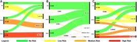
A Sankey diagram showing the measurement of (A) Brgy. Carlatan, (B) Brgy. Catbangen, and (C) the total mangal areas with absence, low, medium, and high risk under the BAU, PPPI, and CP.
DISCUSSION
INFLUENCE OF STRESSORS IN DIFFERENT HABITAT RISK SCENARIOS
Unlike many previous HRA applications that focus on large-scale ecosystem assessments, this study applies a fine-scale community-level approach, incorporating stakeholder engagement and urbanization-specific stressors. This tailored methodology improves applicability for localized conservation planning. Local regions showing varying intensities of risk for vulnerable mangal ecosystems were identified in this study, alongside the consequences and exposure that a particular stressor induces to the local ecosystem. BAU showed that the western part of the mangal ecosystem in Brgy. Carlatan lies at medium-to-high risk of habitat degradation due to the pronounced impact of the roads and land bridges in the area (Figure 3). The western part of Carlatan is highly urbanized, with extensive paved road networks that negatively impact the local ecosystem. Due to its direct and indirect effects, paved road networks offer one of the primary contributors to the degradation of the mangal ecosystem (Hayashi et al., 2019). Road networks can often lead to direct habitat loss due to deforestation, alongside increased habitat fragmentation of the local ecosystem (Almadrones-Reyes and Dagamac, 2023; Bennett, 2017). Integration of these road networks within the ecosystem is evident by the prevalence of land bridges across the whole mangal habitat. Land bridges serve as local pathways humans or livestock use to traverse the area housing numerous aquaculture complexes; the pathways function as a pseudo-road network within the mangrove ecosystem. However, land bridges often correlate with aquaculture development, causing habitat fragmentation, in which the local ecosystem becomes more fragmented, potentially leading to habitat degradation. Mangal deforestation is often associated with high levels of mangal fragmentation, in which a strong correlation with conversion to aquaculture was observed due to the minor yet more numerous intrusions to the local mangal habitat, causing acute fragments or land areas interrupted by aquaculture (Bryan-Brown et al., 2020).
In contrast to the combination of areas with medium-to-high risk, the eastern side of Brgy. Carlatan showed a low-to-medium risk of mangal sites. The relatively low coverage of urbanization, primarily of roads, on its eastern portion and far proximity to the nearest mega infrastructures contributes to the difference in risk intensities between the sides of the area. However, continued pressure imposed on the ecosystem may be associated with the vast coverage of aquaculture surrounding the mangals (Toulec et al., 2019). Among the identified stressors, aquaculture contributes the least to the intensity of risk toward the mangals. Integrating mangroves into aquaculture sites affects their ability to provide biodiversity and ecosystem services when compared to intact mangrove forests, leading to varied risk intensity (McSherry et al., 2023). Due to the limited water exchange surrounding the aquaculture ponds, mangals receive insufficient exposure to tidal intervals, essential for the continuous supply of nutrients and increased productivity (Hayes et al., 2018). The water source for tree stems changes with the seasons, affecting the use of non-saline or saline water based on the availability of rainwater. Mangals need high salinity but the surrounding water may fail to meet the necessary conditions for mangal productivity and aquaculture production (Aduana-Alcantara et al., 2023).
As the distribution of stressors against the mangals is unequal throughout the entire site, there is a notable disparity of risk intensity within Brgy. Carlatan. On the other hand, most of the mangal coverage within Brgy. Catbangen showed low risk (Figure 3). The only identified area with medium-to-high risk is the mangal adjacent to the mangrove walk, which is a ca. 200-m concrete pavement pathway contiguous to the water body and the mangal ecosystem. A few sites on the southern east of the barangay also showed medium risk. The development of the structure caused an area-wide deforestation of the local flora, including the mangroves and their associates. Habitat destruction, overexploitation, area conversion for aquaculture and agriculture, and urban and coastal development significantly threaten the mangal ecosystem and all mangrove species (Polidoro et al., 2010). The concrete structure impeded the river flow, making it stagnant and significantly altering its natural hydrology. Alterations in the regular river basin hydrology and fluvial sediment inflow significantly contribute to the degradation of a local mangal ecosystem (Villate Daza et al., 2020). The high risk in the site shows congruence with the risk intensity on the west of Brgy. Carlatan, in which roads and land bridges configure the leading stressors. The frequency of human disturbance can be associated with the accessibility of the mangal ecosystem by the local communities (Kihia, 2014). Mangal sites experiencing high levels of disturbance can be associated with accessibility regardless of the method of access (such as by foot or vehicle). Furthermore, the lack of water flow in the river may be due to road construction debris brought about by the ‘mangrove walk’ project. Following the presence of mangrove walk, net fishing (E=0.03; C=0.02) and spearfishing (E=0.02; C=0.02) also configure crucial stressors contributing to the medium-to-high risk of mangal within Brgy. Catbangen. Local community members access the river by the mangrove walk to fish. Mangrove walks have higher exposure, but net fishing and spearfishing cause more damage, showing lower resilience and sensitivity to these activities. Due to the lack of regulations for fishing in the area, accessibility of the site and unrestricted mechanisms for fishing activities contribute to the vulnerability of the nearby mangal. Conduction of illegal, unreported, and unregulated fishing can impact the surrounding biodiversity of the site and significantly impact natural resources (Umprasoet et al., 2023; Widjaja et al., 2020).
PREDICTED SHIFTS OF RISK IN CARLATAN AND CATBANGEN
The results in Figure 4 support the analysis of prior studies showing how management interventions, expansion of conservation areas, and reinforcement of regulations pose a high potential to reduce the risk and threat imposed on the stability of the mangal ecosystem (Edokpayi et al., 2017). Based on the inferred information, appropriate interventions can be applied depending on the anthropogenic activities deemed vital to be reduced or potentially relocated to areas that show high resilience to the stressors. Roads and land bridges are the primary contributors to mangal habitat fragmentation leading to the degradation of the local ecosystem. Road networks directly threaten forest ecosystems by their direct ecological effects, i.e., habitat alteration, increased fragmentation, which impedes the horizontal natural processes, and the reduction of critical variability in natural processes and disturbances (Marcantonio et al., 2013, Olfato-Parojinog et al., 2023). Effectively managing these road and land bridge networks by proper policy intervention will drastically reduce the impacts on the natural ecological and hydrological processes of the mangal ecosystems in Brgy. Carlatan, reducing the risks to the ecosystem. However, it is noticeable that the consequence scores of net fishing and spearfishing increased in PPPI when compared to BAU. Generally, when reducing the risk via management interventions, a reduction in exposure is observed rather than a consequence (Umprasoet et al., 2023). This is because consequences depend on how species respond to environmental changes or their species-specific attributes. Hence, when implementing policies, the exposure of a habitat to stressors is reduced rather than modified in its consequences.
Moreover, a decrease in the exposure of habitats among the stressors can improve the classification of risk intensities among the mangal areas (Figure 5). For Brgy. Carlatan, areas with high risk under BAU will shift to medium and low risk under PPPI and CP, respectively. A similar trend is also observed in Brgy. Catbangen. Changes in the exposure of stressors, primarily of a decreased scoring for management intervention indicating high efficiency toward mangals, will contribute to their state of vulnerability. Hence, sufficient and appropriate conservation measures remain crucial factors for this observed effect. The results show congruence with Jia et al. (2016), which shows how stressors toward the mangal sites greatly influence their state of risk and positively impact mangrove conservation under reduced threat exposure. The mangals stand next to urban areas, as in Jia et al. (2016), which shows how stressors toward the mangal sites greatly influence their state of risk and positively impact mangrove conservation, remaining a crucial factor for the potential success. Control of accessibility toward mangrove ecosystems also contributes to the disturbances of the site from anthropogenic activities that impact the suitability of the environment for desired mangrove forest expansions. Similarly, reducing the intensity rating and spatial and temporal overlap of the stressor toward the habitat can also vary the risk among ecosystems as a response to anthropogenic activities (Arkema et al., 2014).
In Figure 5, no risks evince the absence of significant threats that can potentially harm the habitat and its species. This shows how an ecosystem, when normally exposed to natural disturbances, can make it more resilient (McLeod and Salm, 2006). Hence, it is essential to incorporate resilience-building strategies when creating policies. The mangal sites in medium risk under BAU total 32.1% of its area, 1.7% under CP, and 26.6% under PPPI (Figure 5). As the provided scenarios are designed to serve as a basis for formulating guidelines and policies for mitigating current anthropogenic activities, the results portray how contributions from the private and public sectors, alongside the cooperation of the local communities, reduced the overall cumulative risk. Comparing the three scenarios, CP would result in the greatest low-risk habitat area and the least high-risk habitat. However, in achieving the controlled and protected status of the mangal ecosystem in San Fernando, La Union, proper implementation of the policies and management of the local mangal areas are essential in attaining PPPI, which would be a step toward the ideal CP and a significant improvement over the current habitat risk assessment score of the two mangal ecosystem as observed under BAU.
IMPLICATIONS FOR POLICY RECOMMENDATIONS
The mangal ecosystem of San Fernando City, La Union has been considered a vulnerable ecosystem due to many man-made stressors brought upon by urban development (Limbo-Dizon and Dagamac, 2023). At the age and time of integrating SMART cities and communities, in which the coastal communities of San Fernando City fail to offer an exception, environmentally important ecosystems that technically provide relevant ecosystem services, such as the mangal ecosystem, are now being compensated. Evident with the habitat risk assessment by combining field ground truthing and machine learning by GIS applications, the barangays Catbangen and Carlatan are currently exposed to certain stressors, causing high risk (Figure 3). However, the models showing ideal conditions such as those in CP and PPPI have proven that effective management implementation can yield a shift toward from low to zero habitat risk in the two barangay that have vulnerable mangal communities (Figure 4).
Scenarios such as CP and PPPI can be juxtaposed to some national policies already in place to support strategies in conserving the mangal ecosystems, which have been promulgated in the Philippines, i.e., Senate Bill No. (SBN) 1920 (Integrated Coastal Management Act), SBN 639 (National Mangrove Forest Protection and Preservation Act of 2019) and SBN 1993 (Blue Economy Act). These policies revolve around the information dissemination, education, and training programs for local government stakeholders toward strategies of proper mangrove management, which include but are not limited to sapling planting on suitable marine or estuarine habitats. However, such policies must be strictly regulated and implemented regionally to reach the minimal risk shifts as shown on the InVEST model generated for this study. Assessment of the effectiveness of the regulation of environmental programs regarding the mangrove protection of coastal communities is recommended to be evaluated. Moreover, environmental management and collaboration between the government sector and academia for research of proper site selection for mangrove establishment and projects that can cause risk for habitat degradation of mangal ecosystems are highly suggested as a policy recommendation within the boundaries of the regions. Interestingly, the findings in this study are in line with the Kunming-Montreal Global Biodiversity Framework targets, particularly Target 2 (ecosystem restoration) and 8 (minimizing anthropogenic pressures on vulnerable ecosystems). The effectiveness of CP and PPPI suggests potential pathways for achieving these targets at the local and regional levels.
Targeted interventions on specific risk factors contributing to the high-risk areas would lead to ideal scenarios. Reduction of the impact of aquaculture and the enforcement of regulations on fishing activities are suggested to preserve the mangal ecosystem from further degradation. Such measures include implementing zoning regulations to limit aquaculture expansion and gear restrictions to reduce habitat damage and ensure sustainable fishing practices. As for fixed factors that are established in the community, given their importance for civilization, it may be unfeasible to remove them entirely. In such cases, salvaging and replanting mangroves and their associates to areas of lower risk is an ideal solution. Enhanced management effectiveness and stakeholder engagement, absent in the current predicament of La Union, is important in preventing further risk experienced by the mangals. A transdisciplinary approach is recommended when developing comprehensive management plans and policies. This ensures the involvement of stakeholders (i.e., local communities, government agencies, NGOs, and industry representatives) from the outset.
FUTURE DIRECTIVES
While stakeholder consultation helped to refine exposure and consequence values, inherent biases remain. Future research should incorporate a more objective way to quantify the weights of scoring by perhaps incorporating machine learning algorithms. Also, risk assessment accuracy depends on assumptions about how stressors interact spatially. Perhaps, additional field validation and remote sensing analysis could improve the precision of the spatial resolution. However, a long-term ecological monitoring to validate the conservation effectiveness should be established by the local government units, and more proactive residents could participate in a citizen science initiative that will collect continuous data on the ground. Nevertheless, integrating scenario-based risk assessment, such as the results of this study, with validation approaches, provides a data-driven foundation for informed mangal conservation strategies in San Fernando City, La Union.
CONCLUSION
The mangal ecosystems within Brgy. Carlatan, and Catbangen in San Fernando City, La Union, Philippines were subjected to analysis of vulnerability and risk levels from anthropogenic activities by the HRA model. This study showed that both study sites under the BAU scenario showed high cumulative risk, wherein road structures and mangrove walk contributed the most stress for Carlatan and Catbangen, respectively. Notably, the PPPI scenario showed a gradual decrease in exposure the components of which evinced a medium-to-low risk for road structures and land bridges, highlighting the positive impact of active intervention and policy implementation. Urbanization and extensive road networks, encompassing the road structures, land bridges, residential areas, and mega infrastructures, contribute to the degradation of the mangal ecosystem due to the direct habitat loss, increased fragmentation, and alterations in the natural hydrology of the river basin. Furthermore, heightened accessibility of community members and unregulated fishing mechanisms contribute to the vulnerability of mangals. Compared to studies using HRA in Belize (Arkema et al., 2014) and Indonesia (Indriawan et al., 2021), the modeled interventions in San Fernando City showed similar effectiveness in reducing ecosystem risk. However, limitations in regulatory enforcement and socio-economic constraints remain significant challenges.
Well-implemented conservation and management measures, as in the CP and PPPI scenarios, can significantly improve the overall risk profile of mangal ecosystems. The effectiveness of management strategies and policies in mitigating the impact of stressors on the mangal ecosystems emphasizes the importance of strict regulation and effective implementation of data-driven policymaking, especially at the regional level to generate potential shifts in risk levels. Collaboration between the government and academia for research and site selection is crucial for the successful conservation of mangrove ecosystems. Overall, the findings in this study provide a foundation for informed decision-making and underscore the necessity of proactive measures to safeguard vulnerable mangal ecosystems in local coastal communities of the Philippines.
ACKNOWLEDGMENTS
The authors thank the College of Science, University of Santo Tomas (UST), for providing a dissemination and presentation grant. We also acknowledge the technical assistance provided by the staff of the City Environment and Natural Resources Office (CENRO) of San Fernando City, La Union, headed by Mr. Valmar Valdez.
REFERENCES
-
Aduana-Alcantara, A. A., Almadrones-Reyes, K. J. & Dagamac, N. H. A. 2023. Mangrove Land Suitability Assessment Using Weighted Linear Combination: A Case Study of La Union Province Coastline, Philippines. Journal of Sustainability and Environmental Management, 2(2), 83-91. DOI: https://doi.org/10.3126/josem.v2i2.55200
» https://doi.org/10.3126/josem.v2i2.55200 -
Almadrones-Reyes, K. J. & Dagamac, N. H. A. 2023. Land-use/land cover change and land surface temperature in Metropolitan Manila, Philippines using landsat imagery. GeoJournal, 88(2), 1415-1426. DOI: https://doi.org/10.1007/s10708-022-10701-9
» https://doi.org/10.1007/s10708-022-10701-9 -
Anca, J. S., Dionisio, D., Dizon, R., & Hadap, K. 2017. Investigation on the longshore transport mechanism along San Fernando Bay, La Union (Bachelor of Science). Manila: De La Salle University. Available from: Available from: https://animorepository.dlsu.edu.ph/etd_bachelors/6507 Access date: 2025 May 17.
» https://animorepository.dlsu.edu.ph/etd_bachelors/6507 -
Arkema, K. K., Verutes, G., Bernhardt, J. R., Clarke, C., Rosado, S., Canto, M., Wood, S. A., Ruckelshaus, M., Rosenthal, A., McField, M. & De Zegher, J. 2014. Assessing habitat risk from human activities to inform coastal and Marine Spatial Planning: A demonstration in Belize. Environmental Research Letters, 9(11), 114016. DOI: https://doi.org/10.1088/1748-9326/9/11/114016
» https://doi.org/10.1088/1748-9326/9/11/114016 -
Awuku-Sowah, E. M., Graham, N. A. J. & Watson, N. 2022. Investigating mangrove-human health relationships: A review of recently reported physiological benefits. Dialogues in Health, 1, 100059. DOI: https://doi.org/10.1016/j.dialog.2022.100059
» https://doi.org/10.1016/j.dialog.2022.100059 -
Balaoro-Banzuela, R. C., Ocenar-Bautista, C. E., Buebos-Esteve, D. E., Claudio-Paragas, C. Y., Limbo-Dizon, J. E., & Dagamac, N. H. A. 2023. Rapid diversity assessment of litter myxomycete assemblages in the upland and coastal terrains of San Fernando City, La Union, Philippines. Biodiversitas, 24(5). 2877-2886 DOI: https://doi.org/10.13057/biodiv/d240542
» https://doi.org/10.13057/biodiv/d240542 -
Bennett, V. J. 2017. Effects of road density and pattern on the conservation of species and biodiversity. Current Landscape Ecology Reports, 2(1), 1-11. DOI: https://doi.org/10.1007/s40823-017-0020-6
» https://doi.org/10.1007/s40823-017-0020-6 -
Bryan-Brown, D. N., Connolly, R. M., Richards, D. R., Adame, F., Friess, D. A., & Brown, C. J. 2020. Global trends in mangrove forest fragmentation. Scientific Reports, 10(1). DOI: https://doi.org/10.1038/s41598-020-63880-1
» https://doi.org/10.1038/s41598-020-63880-1 -
Camacho, L. D., Gevaña, D. T., Sabino, L. L., Ruzol, C. D., Garcia, J. E., Camacho, A. C. D., Oo, T. N., Maung, A. C., Saxena, K. G., Liang, L., Yiu, E. & Takeuchi, K. 2020. Sustainable mangrove rehabilitation: Lessons and insights from community-based management in the Philippines and Myanmar. APN Science Bulletin, 10(1). DOI: https://doi.org/10.30852/sb.2020.946
» https://doi.org/10.30852/sb.2020.946 -
Cong, W., Sun, X., Guo, H. & Shan, R. 2020. Comparison of the SWAT and InVEST models to determine hydrological ecosystem service spatial patterns, priorities and trade-offs in a complex basin. Ecological Indicators, 112, 106089. DOI: https://doi.org/10.1016/j.ecolind.2020.106089
» https://doi.org/10.1016/j.ecolind.2020.106089 - Daquinan, G. L., Guirhem, G. L. & Medioda, D. P. 2023. Spatio-temporal mapping and monitoring of mangrove forests changes from 1991 to 2021 in Panay Island, Philippines using machine learning. In: IOP Conference Series: Earth and Environmental Science (Vol. 1199, No. 2, pp. 012039).
-
Department of Environment and Natural Resources-Biodiversity Management Bureau. 2022. DENR-BMB cites significant strides in protected area, wildlife conservation. Available from: Available from: https://www.denr.gov.ph/index.php/news-events/press-releases/4725-denr-bmb-cites-significant-strides-in-protected-area-wildlife-conservation Access date: 2025 May 17.
» https://www.denr.gov.ph/index.php/news-events/press-releases/4725-denr-bmb-cites-significant-strides-in-protected-area-wildlife-conservation -
Dida, J. J., Tiburan JR., C., Tsutsumida, N. & Saizen, I. 2021. Carbon Stock Estimation of Selected Watersheds in Laguna, Philippines Using InVEST. Philippine Journal of Science, 150(2). DOI: https://doi.org/10.56899/150.02.15
» https://doi.org/10.56899/150.02.15 -
Edokpayi, J. N., Odiyo, J. O. & Durowoju, O. S. 2017. Impact of wastewater on surface water quality in developing countries: A case study of South Africa. Water Quality, 401-416. DOI: https://doi.org/10.5772/66561
» https://doi.org/10.5772/66561 -
Estoque R. C., Myint S. W., Wang C., Ishtiaque A., Aung T. T., Emerton L., Ooba, M., Hijioka, Y., Mon, M. S., Wang, Z. & Fan, C. 2018. Assessing environmental impacts and change in Myanmar’s mangrove ecosystem service value due to deforestation, (2000-2014). Global Change Biology, 24, 5391-5410. DOI: https://doi.org/10.1111/gcb.14409
» https://doi.org/10.1111/gcb.14409 -
Feller, I. C., Friess, D. A., Krauss, K. W. & Lewis, R. R. 2017. The State of the World’s Mangroves in the 21st Century under Climate Change. Hydrobiologia, 803, 1-12. DOI: https://doi.org/10.1007/s10750-017-3331-z
» https://doi.org/10.1007/s10750-017-3331-z - Fletcher, J. M., Francis, D. J., Morris, R. D., & Lyon, G. R. (2005). Evidence-based assessment of learning disabilities in children and adolescents. Journal of Clinical Child and Adolescent Psychology, 34(3), 506-522.
-
Garcia, K. B., Malabrigo, P. L. & Gevaña, D. T. 2013. Philippines’ mangrove ecosystem: Status, threats and conservation. Mangrove Ecosystems of Asia, 81-94. DOI: https://doi.org/10.1007/978-1-4614-8582-7_5
» https://doi.org/10.1007/978-1-4614-8582-7_5 -
Giri, C. 2016. Observation and monitoring of mangrove forests using remote sensing: Opportunities and challenges. Remote Sensing, 8, 783. DOI: https://doi.org/10.3390/rs8090783
» https://doi.org/10.3390/rs8090783 -
Göltenboth, F., Langenberger, G. & Widmann, P. 2006. Beach forests. Ecology of Insular Southeast Asia, 281-295. DOI: https://doi.org/10.1016/b978-044452739-4/50016-4
» https://doi.org/10.1016/b978-044452739-4/50016-4 -
Gouvêa, L. P., Serrão, E. A., Cavanaugh, K., Gurgel, C. F., Horta, P. A. & Assis, J. 2022. Global impacts of projected climate changes on mangrove forests’ extent and aboveground biomass. Diversity and Distributions, 28, 2349-2360. DOI: https://doi.org/10.1111/ddi.13631
» https://doi.org/10.1111/ddi.13631 -
Hayashi, S. N., Souza-Filho, P. W., Nascimento, W. R. & Fernandes, M. E. 2019. The effect of anthropogenic drivers on spatial patterns of mangrove land use on the Amazon Coast. PLOS ONE, 14(6). DOI: https://doi.org/10.1371/journal.pone.0217754
» https://doi.org/10.1371/journal.pone.0217754 -
Hayes, M. A., Jesse, A., Welti, N., Tabet, B., Lockington, D. & Lovelock, C. E. 2018. Groundwater enhances above-ground growth in mangroves. Journal of Ecology, 107(3): 1120-1128. DOI: https://doi.org/10.1111/1365-2745.13105
» https://doi.org/10.1111/1365-2745.13105 - Hobday, A. J., Smith, A. D. M., Stobutzki, I. C., Bulman, C., Daley, R., Dambacher, J. M., ... & Zhou, S. (2011). Ecological risk assessment for the effects of fishing. Fisheries Research, 108(2-3), 372-384.
-
Indriawan, D., Taofiqurrohman, A., Riyantini, I. & Faizal, I. 2021. Assessment of risk levels of Mangrove Forest due to oil spill in Muara Gembong, Bekasi Regency. ES3 Web of Conferences, 324(01004). Maritime Continent Fulcrum International Conference (MaCiFIC 2021). DOI: https://doi.org/10.1051/e3sconf/202132401004
» https://doi.org/10.1051/e3sconf/202132401004 -
Jia, M., Liu, M., Wang, Z., Mao, D., Ren, C. & Cui, H. 2016. Evaluating the effectiveness of conservation on mangroves: A remote sensing-based comparison for two adjacent protected areas in Shenzhen and Hong Kong, China. Remote Sensing , 8(8), 627. DOI: https://doi.org/10.3390/rs8080627
» https://doi.org/10.3390/rs8080627 - Kihia, C. M. 2014. Impact of human physical disturbance on mangrove forest structure at Gazi Bay, Kenya. Egerton Journal of Science and Technology, 14, 31-47.
- La Union Provincial Land Use Committee. 2015. (rep.). San Fernando City Comprehensive Land Use Plan C.Y. 2015-2025 (Vol. 2). San Fernando, PLUC.
- Limbo-Dizon, J. E., & Dagamac, N. H. A. 2023. Assessment of coastal change detection on an urban coastline: A case study in metropolitan Manila, Philippines. In: IOP Conference Series: Earth and Environmental Science (Vol. 1165, No. 1, p. 012015).
-
Marcantonio, M., Rocchini, D., Geri, F., Bacaro, G., & Amici, V. 2013. Biodiversity, roads, & landscape fragmentation: Two Mediterranean cases. Applied Geography, 42, 63-72. DOI: https://doi.org/10.1016/j.apgeog.2013.05.001
» https://doi.org/10.1016/j.apgeog.2013.05.001 -
McLeod, E., & Salm, R. V. 2006. Managing mangroves for resilience to climate change. Gland, The World Conservation Union - IUCN. Available from: Available from: http://news.bbc.co.uk/nol/shared/bsp/hi/pdfs/311006_iucn_mangroves_guide.pdf Access date: 2025 May 17.
» http://news.bbc.co.uk/nol/shared/bsp/hi/pdfs/311006_iucn_mangroves_guide.pdf -
McSherry, M., Davis, R. P., Andradi-Brown, D. A., Ahmadiyya, G. N., Kempen, M. V. & Brian, S. W. 2023. Integrated mangrove aquaculture: The sustainable choice for mangroves and aquaculture? Frontiers for Global Change, 6. DOI: https://doi.org/10.3389/ffgc.2023.1094306
» https://doi.org/10.3389/ffgc.2023.1094306 -
Phan M. H. & Stive M. J. F. 2022. Managing mangroves and coastal land cover in the Mekong delta. Ocean & Coastal Management, 219, 106013. DOI: https://doi/org/10.1016/j.ocecoaman.2021.106013
» https://doi/org/10.1016/j.ocecoaman.2021.106013 -
Olfato-Parojinog, A., Sobremonte-Maglipon, P. A., Limbo-Dizon, J. E., Almadrones-Reyes, K. J., Dagamac, N. H. A. 2023. Land use/land cover changes (LULCC) using remote sensing analyses in Rizal, Philippines. Geojournal, 88(6), 6105-6118. DOI: https://doi.org/10.1007/s10708-023-10959-7
» https://doi.org/10.1007/s10708-023-10959-7 -
Polidoro, B. A., Carpenter, K. E., Collins, L., Duke, N. C., Ellison, A. M., Ellison, J. C., Farnsworth, E. J., Fernando, E. S., Kathiresan, K., Koedam, N. E., Livingstone, S. R., Miyagi, T., Moore, G. E., Ngoc Nam, V., Ong, J. E., Primavera, J. H., Salmo, S. G., Sanciangco, J. C., Sukardjo, S., … Yong, J. W. 2010. The loss of species: Mangrove extinction risk and geographic areas of global concern. PLoS ONE, 5(4). DOI: https://doi.org/10.1371/journal.pone.0010095
» https://doi.org/10.1371/journal.pone.0010095 -
Prance, G. T. & Tomlinson, P. B. 1987. The botany of mangroves. Brittonia, 39(1), 10. DOI: https://doi.org/10.2307/2806964
» https://doi.org/10.2307/2806964 -
Primavera, J. 2004. Philippine mangroves: status, threats and sustainable development. In: Vannucci, M. (Ed.). Mangrove Management and Conservation: Present and Future (pp. 192-207). Tokyo: United Nations University Press. Available from: Available from: http://hdl.handle.net/10862/480 Access date: 2025 May 17.
» http://hdl.handle.net/10862/480 - Provincial Government of La Union. (2002). Provincial Environmental Protection and Management Code of La Union. San Fernando City, La Union: Provincial Government.
-
Quevedo, J. M., Uchiyama, Y. & Kohsaka, R. 2019. Perceptions of local communities on mangals, their services and management: Implications for eco-DRR and Blue Carbon Management for Eastern Samar, Philippines. Journal of Forest Research, 25(1), 1-11. DOI: https://doi.org/10.1080/13416979.2019.1696441
» https://doi.org/10.1080/13416979.2019.1696441 -
Rivera, P. C., Amik, J. E., Escobar, M. I., Olfato-Parojinog, A., Sobremonte-Maglipon, P. A., Limbo-Dizon, J. E. & Dagamac, N. H. A. 2024. Land use/land cover change along the coastline of La Union, Philippines. Journal of Geomatics, 18(1), 103-111. DOI: https://doi.org/10.58825/jog.2024.18.1.129
» https://doi.org/10.58825/jog.2024.18.1.129 - Salmo III, S. G., Favis, A. M. T. & Ting, M. N. S. 2014. State of mangroves in La Union. In: Salmo III, S. G., Favis, A. M. T. & Ting, M. N. S. (Ed.). State of the Mangroves Summit: Northwestern Luzon Proceedings (pp. 46-48). Manila: Ateneo de Manila University.
- Sharp, R., Tallis, H. T., Ricketts, T., Guerry, A. D., Wood, S. A., Chaplin-Kramer, R., Nelson, E., Ennaanay, D., Wolny, S., Olwero, N., Vigerstol, K., Pinnington, D., Mendoza, G., Aukema, J., Foster, J., Forrest, J., Cameron, D., Arkema, K., Lonsdorf, E., Kennedy, C., Verutes, G., Kim, C. K., Guannel, G., Papenfus, M., Toft, J. M. M. B., Marsik, M., Bernhardt, J., Griffin, R., Glowinski, K., Chaumont., N., Perelman, A., Lacayo, M., Mandle, L., Hamel, P., Vogl, A. L., Rogers, L. & Bierbower, W. 2015. InVEST 3.2.0 Beta User’s Guide (pp. 114-131). Stanford: The Natural Capital Project.
- Stamoulis, K. A., & Delevaux, J. M. (2015). Data requirements and tools to operationalize marine spatial planning in the United States. Ocean & Coastal Management , 116, 214-223.
- Studwell, A., Hines, E., Nur, N., & Jahncke, J. (2021). Using habitat risk assessment to assess disturbance from maritime activities to inform seabird conservation in a coastal marine ecosystem. Ocean & Coastal Management , 199, 105431.
-
Tinh, P. H., Mackenzie, R. A., Hung, T. D., Hanh, N. T. H., Hanh, N. H., Manh, D. Q., Ha, H. T. & Tuan, M. S. 2022. Distribution and drivers of Vietnam mangrove deforestation from 1995 to 2019. Mitigation Adaptation Strategies for Global Change, 27(29). DOI: https://doi.org/10.1007/s11027-022-10005-w
» https://doi.org/10.1007/s11027-022-10005-w -
Toulec, T., Lhota, S., Soumarova, H., Sariyanto Putera, A. K. & Kustiawan, W. 2019. Shrimp farms, fire, or palm oil? Changing causes of the proboscis monkey habitat loss. Global Energy Conservation, 21, e00863. DOI: https://doi.org/10.1016/j.gecco.2019.e00863
» https://doi.org/10.1016/j.gecco.2019.e00863 -
Umprasoet, W., Mu, Y., Somrup, S., Junchompoo, C., Guo, Z. & Zhang, Z. 2023. Assessment of habitat risks caused by human activities and integrated approach to marine spatial planning: The case of Srirarcha district - Sichang island. Coasts, 3(3), 190-208. DOI: https://doi.org/10.3390/coasts3030012
» https://doi.org/10.3390/coasts3030012 -
Villate Daza, D. A., Sánchez Moreno, H., Portz, L., Portantiolo Manzolli, R., Bolívar-Anillo, H. J. & Anfuso, G. 2020. Mangrove forests evolution and threats in the Caribbean Sea of Colombia. Water, 12(4), 1113. DOI: https://doi.org/10.3390/w12041113
» https://doi.org/10.3390/w12041113 -
Walters, B. B. 2004. Local Management of mangals in the Philippines: Successful conservation or efficient resource exploitation? Human Ecology, 32(2), 177-195. DOI: https://doi.org/10.1023/b:huec.0000019762.36361.48
» https://doi.org/10.1023/b:huec.0000019762.36361.48 - Widjaja, S., Long, T. & Wirajuda, H. 2020. Illegal, Unreported and Unregulated Fishing and Associated Drivers. Washington, DC, World Resources Institute.
-
DATA AVAILABILITY STATEMENT
The data supporting this study can be found in Zenodo. Additional datasets generated and/or analyzed during the current study are available from the corresponding author on reasonable request.
-
FUNDING
This research was funded by the National Research Council of the Philippines (NRCP Project No. E-253) under Project MARVELS of the Program INFLORAS. Partial financial support was provided through a small research grant from UST-RCNAS and the National Academy of Science and Technology - Department of Science and Technology (NAST-DOST). Additional research support was received from the DOST-Philippine Council for Agriculture, Aquatic, and Natural Resources Research and Development (DOST-PCAARRD) through the Balik Scientist Program. CF received a student thesis grant from the DOST-Science Education Institute (DOST-SEI).
SUPPLEMENTARY MATERIAL
The Scoring Matrix by Stakeholders for Habitat Risk Assessment under Three Management Scenarios is available online at Zenodo.
The data supporting this study can be found in Zenodo. Additional datasets generated and/or analyzed during the current study are available from the corresponding author on reasonable request.